
Castle Geyser
| Castle Geyser | |
|---|---|
 | |
 | |
| Location | Upper Geyser Basin, Yellowstone National Park, Teton County, Wyoming |
| Coordinates | 44°27′50″N 110°50′03″W / 44.46389°N 110.83417°W |
| Elevation | 7,333 feet (2,235 m) |
| Type | Cone geyser |
| Eruption height | 90 feet (27 m) |
| Frequency | 10 to 12 hours |
| Duration | 20 minutes |
| Common | |
| Lua error in Module:Location_map at line 526: Unable to find the specified location map definition: "Module:Location map/data/SouthernSectionUpperGeyserBasinCastle.JPG" does not exist. | |
Castle Geyser is a cone geyser in the Upper Geyser Basin of Yellowstone National Park. It is noted for the particularly large sinter deposits, which form its cone. These deposits have been likened in appearance to a castle.
When the geyser was given this name in 1870, the top edges of the structure resembled the typical profile associated with the modern concept of a castle, having the appearance of a large keep, multiple turrets, and especially because of the crenellation along the top edges of what resembled its towers. This distinctive confirmation is clear in the drawing made at that time, which is the first image in the gallery displayed at the end of this article. As demonstrated in the images presented in the gallery, the conformation of the structure varies from time to time because of layers of mineral deposited in successive eruptions.
History
On September 18, 1870, the Washburn-Langford-Doane Expedition entered the Upper Geyser Basin. Eventually, members of the expedition named seven geysers they observed in the basin. The appearance of this geyser led Lieutenant Gustavus Cheyney Doane to name it Castle Geyser.[1] Nathaniel P. Langford gave this account in his 1871 Scribner's article:
"The Castle," situated on the summit of an incrusted mound, has a turreted crater through which a large volume of water is expelled at intervals of two or three hours to the height of fifty feet, from a discharging orifice about three feet in diameter. The architectural features of the silicious sinter surrounding it, which is very massive and compact, indicating that at some former period the flow of water must have been much greater than at present, suggested its name. A vent near it is constantly discharging a large stream of boiling water, and when the geyser is in action the water in this vent boils and bubbles with great fierceness.[2]
Eruption
The Castle Geyser has a 10–12 hour eruption cycle. The geyser erupts hot water for about 20 minutes in a vertical column that reaches a height of 90 feet (27 meters) before changing to a noisy steam phase that issues for 30–40 minutes.[3]
The sinter cone for Castle Geyser has been dated to around 1022 using carbon-14 dating. This date is much younger than the originally-presumed age of 5,000 to 15,000 years. A 3-D laser scan made of the cone reveals evidence that this geyser has evolved through four to five distinct stages to reach its current configuration.[4]
In November 2002, an earthquake in Denali National Park and Preserve, Alaska caused Castle Geyser, as well as other geysers in Yellowstone, to decrease in eruption frequency.[5] The affected geysers have returned to their previous pattern since that time, however.
-
![Original sketch of Castle Geyser when documented by the Washburn Expedition of 1870 and showing the sharp resemblance to castles[6]](//upload.wikimedia.org/wikipedia/commons/thumb/3/33/CastleGeyserConeOriginalSketch.JPG/150px-CastleGeyserConeOriginalSketch.JPG) Original sketch of Castle Geyser when documented by the Washburn Expedition of 1870 and showing the sharp resemblance to castles[6]
Original sketch of Castle Geyser when documented by the Washburn Expedition of 1870 and showing the sharp resemblance to castles[6] -
 William Henry Jackson, 1872. Crested Pool is in the foreground.
 -
 Painting, Thomas Moran, 1874
 -
 January 1887, F. Jay Haynes
 -
 Ansel Adams, 1942
 -
 c. 1952
 -

-
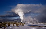 Steam phase in winter
 -
 2005
2005
![Original sketch of Castle Geyser when documented by the Washburn Expedition of 1870 and showing the sharp resemblance to castles[6]](/wiki/File:CastleGeyserConeOriginalSketch.JPG)


References
- ^ Bauer, Clyde Max (1947). Yellowstone Geysers. Yellowstone Park, Wyoming: Haynes. ASIN B0007E44C4.
- ^ Langford, Nathaniel P. (1871). "The Wonders of the Yellowstone". Scribner's Monthly. II (1–2): 124.
{{cite journal}}: Cite has empty unknown parameter:|coauthors=(help); Unknown parameter|month=ignored (help) - ^ "Castle Geyser". Old Faithful Area Tour. Retrieved 2005-09-15.
- ^ Foley, Duncan. (2004). "How Does Your Geyser Grow? 3-D Laser Scanning and Preliminary 14C Dating of Castle Geyser, Upper Geyser Basin, Yellowstone National Park, Wyoming". Geological Society of America – Rocky Mountain (56th Annual) and Cordilleran (100th Annual) Joint Meeting (May 3–5, 2004), 15
- ^ "Quake in Alaska Changed Yellowstone Geysers". University of Utah News and Relations. Retrieved 2005-09-15.
- ^ Langford, Nathaniel Pitt (1905). The Discovery of Yellowstone Park; Diary of the Washburn Expedition to the Yellowstone and Firehole Rivers in the Year 1870. St. Paul, MN: Frank Jay Haynes. p. 123.
External links
- "Castle Geyser movie". Retrieved September 16, 2005.
Yellowstone National Park - Upper Geyser Basin | ||
|---|---|---|
Geothermal features and other attractions in the Upper Geyser Basin | ||
| Geysers |
|  |
| Hot springs | ||
| Structures and history | ||
| Geography | ||
| ||