Dadu River
| Dadu River | |
|---|---|
 The upper Dadu River | |
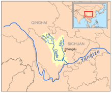
 Map of the Min and Dadu River drainage basin | |
| Native name | Dadu He—Tatu River Error {{native name checker}}: parameter value is malformed (help) |
| Physical characteristics | |
| Source | |
| • location | Confluence of Dajin Chuan and Xiaojin Chuan at Danba |
| Mouth | |
• location | Min River (Min Jiang) at Leshan |
| Basin features | |
| Tributaries | |
| • right | Tianwanhe |
The Dadu River (Chinese: 大渡河; pinyin: Dàdù Hé; Wade–Giles: Tatu Ho) is located in Sichuan province, southern China. It is a tributary of the Min River (Mín Jiāng), which is a tributary of the Yangtze River (Chang Jiang).
The Shuangjiangkou Dam will be built in its valley.
History
The river is noted for being crossed by the Luding Bridge, a historically important bridge. It was the site of a famous retreat by the Chinese communists from the Kuomintang troops during the Long March.
Landslide dam
The Kangding Louding earthquake of 1786 caused a landslide dam in the Dadu. Ten days later, 10 June 1786, the dam broke and the resulting flood extended 1,400 kilometres (870 mi) downstream, and killed 100,000 people. It is the second-deadliest landslide disaster on record.[1]

Culture
A song from the Chinese musical The East Is Red is entitled "Across the Dadu River." The Grand/Giant Buddha is located on the high side of the confluence of the Dadu and Min Rivers at Leshan. It is a frequent tourist destination.
Dams
The Dadu is being heavily developed, primarily for hydroelectric power. As of March 2014, a total of 26 dams are completed, under construction or planned for the river. Those dams are listed below from downstream to upstream.[2][3]
- Angu Dam – Under construction, 320 MW
- Fahuasi Dam – Planned, 240 MW
- Shawan Dam – Under construction, 480 MW
- Tongjiezi Dam – Completed, 600 MW
- Gongzui Dam – Completed, 770 MW
- Shaping Dam – Programmed, 630 MW
- Zhentouba Dam – Programmed, 950 MW
- Shenxigou Dam – Under construction, 660 MW
- Pubugou Dam – Completed, 3,600 MW
- Laoyingyan Dam – Programmed, 640 MW
- Longtoushi Dam – Completed, 700 MW
- Dagangshan Dam – Under construction, 2,600 MW
- Yingliangbao Dam – Programmed, 1,200 MW
- Luding Dam – Completed, 920 MW
- Huangjinping Dam – Under construction, 850 MW
- Changheba Dam – Under construction, 2,600 MW
- Houziyan Dam – Under construction, 1,700 MW
- Danba Dam – Programmed, 1,300 MW
- Badi Dam – Programmed, 800 MW
- Anning Dam – Programmed, 380 MW
- Jinchuan Dam – Programmed, 860 MW
- Shuangjiangkou Dam – Under construction, 2,000 MW
- Busigou Dam – Planned, 360 MW
- Dawei Dam – Planned, 270 MW
- Bala Dam – Planned, 740 MW
- Xiaerxia Dam – Planned, 540 MW
References
- ^ Schuster, R.L. and G. F. Wieczorek, "Landslide triggers and types" in Landslides: Proceedings of the First European Conference on Landslides 2002 A.A. Balkema Publishers. p.66
- ^ Dong, Luan. "INTERACTIVE: Mapping China's "Dam Rush"". Wilson Center. Retrieved 15 June 2014.
- ^ "The Last Report on China's Rivers". China's Rivers Report. March 2014. Retrieved 15 June 2014.
External links
![]() Media related to Dadu River (Sichuan) at Wikimedia Commons
Media related to Dadu River (Sichuan) at Wikimedia Commons
29°32′58″N 103°45′53″E / 29.54944°N 103.76472°E
