
Dolovo, Pančevo
Dolovo
Долово | |
|---|---|
Village | |
 Dolovo Location of Dolovo within Serbia | |
| Coordinates: 44°54′02″N 20°52′23″E / 44.90056°N 20.87306°E | |
| Country | Serbia |
| Province | Vojvodina |
| District | South Banat |
| Population (2011) | |
| • Dolovo | 6,146 |
| Time zone | UTC+1 (CET) |
| • Summer (DST) | UTC+2 (CEST) |
| Area code | +381(0)13 |
| Car plates | PA |

Dolovo (Serbian Cyrillic: Долово) is a village in Serbia. It is situated in the Pančevo municipality, in the South Banat District, Vojvodina province. The village has a Serb ethnic majority and its population is 6,146 (2011 census). The place name means location of troughs.
Historical population
- 1948: 5,983
- 1953: 6,273
- 1961: 6,766
- 1971: 6,582
- 1981: 6,836
- 1991: 6,790
- 2002: 5,346 (5,346 Serbs, 927 Romanians, 83 Romani people and 479 Others)
See also
Gallery
-
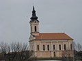 Serbian Orthodox Church Saint Nicholas
 -
 Bell tower of the Serbian Orthodox Church
 -
 Northwestern part of Deliblatska peščara nearby Dolovo


External links
Wikimedia Commons has media related to Dolovo.
- Dolovo on the Official Website by the municipality of Pančevo (Serbian)
- History of the Serbian Orthodox Church Saint Nicholas on the Website by Eparchy of Banat (Serbian)
This South Banat District, Vojvodina location article is a stub. You can help Wikipedia by expanding it. |