Douglas Road station
Appearance
| Metrorail metro station | |||||||||||||||
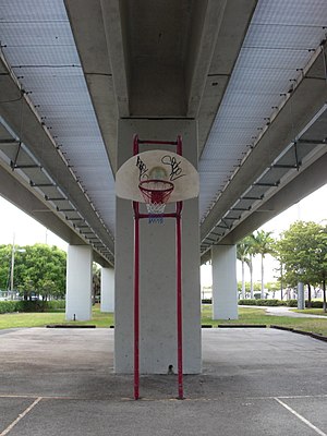
 Basketball court beneath station trackage | |||||||||||||||
| General information | |||||||||||||||
| Location | 3100 South Douglas Road Coral Gables, Florida | ||||||||||||||
| Coordinates | 25°43′57″N 80°15′17″W / 25.73250°N 80.25472°W | ||||||||||||||
| Owned by | Miami-Dade County | ||||||||||||||
| Line(s) | Lua error: expandTemplate: template "MDM color" does not exist.Lua error: expandTemplate: template "MDM color" does not exist. | ||||||||||||||
| Platforms | 1 island platform | ||||||||||||||
| Tracks | 2 | ||||||||||||||
| Connections | |||||||||||||||
| Construction | |||||||||||||||
| Parking | Park and ride (226 spaces) | ||||||||||||||
| Accessible | Yes | ||||||||||||||
| Other information | |||||||||||||||
| Station code | DRD | ||||||||||||||
| History | |||||||||||||||
| Opened | May 20, 1984 | ||||||||||||||
| Passengers | |||||||||||||||
| 2012 | 1.3 million [1] | ||||||||||||||
| Services | |||||||||||||||
| |||||||||||||||
Douglas Road station is a station on the Metrorail rapid transit system just southwest of Coconut Grove, in Miami, Florida. It is the southernmost Metrorail station in Miami city limits, although it has a Coral Gables address. The station is located at the intersection of Douglas Road (West 37th Avenue) and South Dixie Highway (US 1), three blocks south Bird Road (SW 40th Street). It opened to service May 20, 1984.

Station layout
| P Platform level |
Southbound | ← Downtown Express does not stop here ← Green Line, Orange Line toward Dadeland South (University) |
| Island platform, doors will open on the left | ||
| Northbound | Green Line toward Palmetto (Coconut Grove) → Orange Line toward Miami Airport (Coconut Grove) → Downtown Express does not stop here → | |
| G | Street level | Exit/entrance, buses, parking |
References
External links
 Media related to Douglas Road (Metrorail station) at Wikimedia Commons
- MDT – Metrorail Stations
- Station from Google Maps Street View


