
Farmington Historic District (Farmington, Michigan)
This article lacks inline citations besides NRIS, a database which provides minimal and sometimes ambiguous information. (November 2013) |
Farmington Historic District | |
 The Masonic Lodge is near the center of this historic district and was previously used as the city hall | |
 Boundaries of the district | |
| Location | Grand River Ave and Shiawassee Ave from Warner St to Jct, Farmington, Michigan |
|---|---|
| Coordinates | 42°27′56″N 83°22′41″W / 42.46556°N 83.37806°W |
| Area | 35 acres (14 ha) |
| Built | 1823 |
| Architect | Johnson S. Prall |
| Architectural style | Greek Revival, Late Victorian |
| NRHP reference No. | 76001034[1] |
| Added to NRHP | June 18, 1976 |
Farmington Historic District is the town center of Farmington, Michigan. It was listed on the National Register of Historic Places in 1976. The area roughly corresponds to the section of Grand River Avenue and Shiawassee Avenue from Warner Street to junction of Grand River and Shiawassee.
The district includes some significant buildings in Farmington:
- Governor Fred M. Warner House
- The Masonic Lodge (formerly City Hall)
- Farmington Civic Theatre
Gallery
-
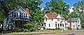
 Houses on Farmington Road
 -
 House on Farmington Road
 -
 Houses on Grand River
 -
 Commercial Buildings on Grand River
 -
 Commercial Buildings on Grand River
 -
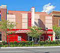 Commercial Buildings on Grand River
 -
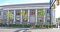 Commercial Buildings on Grand River


References
External links
 Media related to Farmington Historic District at Wikimedia Commons
- Farmington Historical Commission
| Lists by county |
|  |
|---|---|---|
| Other lists | ||
This Oakland County, Michigan location article is a stub. You can help Wikipedia by expanding it. |
This article about a property in Michigan on the National Register of Historic Places is a stub. You can help Wikipedia by expanding it. |