
Formby: Difference between revisions
Raymondwinn (talk | contribs) Undid revision 474095841 by 195.43.48.138 (talk) |
|||
| Line 144: | Line 144: | ||
*[[Mikey willo]] |
*[[Mikey willo]] |
||
Other notable people: |
Other notable people: |
||
*Nye Hughes - infamous drunk |
|||
*[[Thomas Dowling]] - Footballing Referee |
*[[Thomas Dowling]] - Footballing Referee |
||
*[[Moby]], world renowned music producer, lived on Shireburn road.<ref>{{cite web|url=http://www.virginmedia.com/homefamily/property/uks-poorest-and-richest-streets.php?ssid=14 |title=Liverpool: richest street - Revealed: UK's poorest and richest streets - Pictures - Homefamily |publisher=Virgin Media |date= |accessdate=2011-12-13}}</ref> |
*[[Moby]], world renowned music producer, lived on Shireburn road.<ref>{{cite web|url=http://www.virginmedia.com/homefamily/property/uks-poorest-and-richest-streets.php?ssid=14 |title=Liverpool: richest street - Revealed: UK's poorest and richest streets - Pictures - Homefamily |publisher=Virgin Media |date= |accessdate=2011-12-13}}</ref> |
||
Revision as of 20:50, 30 January 2012
| Formby | |
|---|---|
 Red squirrel in Formby | |
| Population | 24,996 |
| OS grid reference | SD293074 |
| Civil parish |
|
| Metropolitan borough | |
| Metropolitan county | |
| Region | |
| Country | England |
| Sovereign state | United Kingdom |
| Post town | LIVERPOOL |
| Postcode district | L37 |
| Dialling code | 01704 |
| Police | Merseyside |
| Fire | Merseyside |
| Ambulance | North West |
| UK Parliament | |
Formby is a town and civil parish in the Metropolitan Borough of Sefton[1] in Merseyside, England. It has a population of approximately 25,000.
Historically a part of Lancashire, three manors are recorded in the Domesday book under "Fornebei" as Halsall, Walton and Poynton.[2] The town's early recorded industry points to cockle raking, and shrimp fishing (in addition to arable ventures) last through into the 19th century.[2] By 1872 the township and sub-district as of 1872 was made up of two chapelries (St. Peter and St. Luke), and contained Birkdale township, the hamlets of Ainsdale and Raven-Meols and Altcar parish.[2][3] Formby was built on the plain adjoining the Irish Sea coast a few miles north of the Crosby channel where the sands afford shelter to the towns.[2]
Formby is affluent[4][5] with high owner-occupation and car ownership.[5] Strong economic ties are retained with nearby Liverpool to which it acts as a dormitory town for some of its residents.[6][7]
The greater area is a popular tourist destination during the summer months, with day trippers attracted to its beaches, sand dunes, and wildlife - most particularly the red squirrels. and Natterjack toads.[8] The area is a conserved by the National Trust, and designated a site of Specific Scientific Interest.[5][9]
History
Erosion of sand on the beach at Formby is revealing layers of mud and sediment, laid down and covered in the late Neolithic/early Bronze Age, approximately 3,500 - 4,000 years ago.[10] These sediments often contain the footprints of humans and animals (most commonly aurochs) from that period.[11]
The common place-name ending -by is from the Scandinavian byr meaning "homestead", "settlement" or "village". The village of Formby was originally spelt Fornebei and means "village belonging to Forni".[2] At that time Fornibiyum was a well-known Norse family name. He could have been the leader of the invading expedition which took possession of this coast. Until its closure in 1998, Oslo Airport in Norway was situated in a town called Fornebu.
It was from Ireland in about 960 AD that these Norsemen or Vikings[12] first came to the west coast of Lancashire, first trading or raiding and then settling. Tradition says that the Viking invaders failed to defeat the native Anglo-Saxons on the coast of Formby, so they sailed inland, up the River Alt, and attacked from the rear.[13] Dangus Lane, on the east side of the village, is sometimes called Danesgate Land, being connected by local traditions with this incursion.
Formby Hall is a Grade II listed building dating back to 1223. It has traditionally been the home of the Lords of the Manor. Much of the land around it is now a golf course.
Formby beach is the location of the first lifeboat station in the UK. Established as early as 1776 by William Hutchinson, Dock Master for the Liverpool Common Council. It was the first lifeboat station in the United Kingdom, and possibly the world. One night, two years previous, eighteen ships were stranded at the mouth of the Mersey drowning 75 people.[14][15] The foundations of the last of the lifeboat station buildings remain on the beach.[16] The last launch took place in 1916. Remarkably a film survives of this event.[17]
Formby is home to RAF Station Woodvale, a small RAF station on the outskirts of the town.[18] The airfield opened in 1941 and is a ex WW2 fighter station with three active runways, the main runway being a mile in length.[19] Today it is used by RAF for light aircraft and fighter training, as well as a few civilian aircraft. The station is also home to Merseyside Police's helicopter,[20] known as 'Mike One'.[21] The RAF Station was also home to the last ever operational service of the British legend, the Spitfire. In 1957 the last Spitfire was to fly with military markings in British took off from RAF Woodvale on an operational mission.[22] Woodvale is also home to the Woodvale Rally, one of the biggest shows on an active MOD station in the North West.[23]
Holy Trinity Church is believed to be the only church in the country which holds a special service in which seasonal greenery collected by the menfolk of the parish and then twined into wreaths by the ladies is lifted into place as part of a service of worship in the run-up to Christmas.
Governance
Until 1974, Formby was an urban district (Formby Urban District) within the administrative county of Lancashire. Since 1 April 1974, it has formed part of the Metropolitan Borough of Sefton, in Merseyside.
From 1950 until 2010 Formby formed part of the constituency of Crosby, The MP for Crosby from 1997 until 2010 was Claire Curtis-Thomas, a member of the Labour Party, prior to her election the seat was generally considered to be a safe Conservative Party stronghold with Tory MP's elected at every election barring the Crosby by-election, 1981 where Shirley Williams of the Social Democratic Party was elected to represent the constituency. As a result of the Crosby constituency being abolished for the 2010 general election, Formby is part of the newly created Sefton Central constituency represented by Bill Esterson, a member of the Labour Party.
For elections to Sefton Council, Formby is divided between two electoral wards with three councillors each. Harington ward, whose councillors are Gillian Cuthbertson - Independent Conservative, Alf Doran - UKIP, and Denise Dutton - Conservative, and Ravenmeols ward, whose councillors are Catie Page - Labour Party, Barry Griffiths - Conservative, David Mcivor - Conservative.
Geography

Formby is a coastal town roughly 7 sq miles (17 km²) and part of Sefton in the north west of Merseyside. The town is built upon the west of a large flat area of land called the West Lancashire Coastal Plain. The town is 1.5 feet (0.5 metres) below sea level at its lowest point. Formby's highest point is within the sand dunes that separate the Irish Sea from Formby, sand dunes are ever changing in shape and formation so there is no fixed point.[24] The River Alt runs in to the Irish Sea just south of Formby at Hightown.
The town is rurally landlocked; the land between Formby and the areas of Southport, Ormskirk and Liverpool is green belt land and is used for arable agricultural purposes. The areas around the urban fringe are drained by irrigation ditches and open areas get boggy in the winter months. Earth in urban areas is well drained, very loose and sandy.
The section of land between Formby and the coast is varied in vegetation, wildlife and terrain. This area includes pine forests: natural and man-made, sand dunes, marram grass, deciduous woodland, seasonal ponds and lakes. Large areas of this land are protected by the National Trust.
Formby is in a temperate climate zone, with mild winters and warm summers. Formby's biggest threat is global warming as the town is built on a flood plain, being situated next to the coast and being below sea level.
Economy
The main shopping area is locally known as The Village; here the town upholds an array of shops including a Boots, Dorothy Perkins and a New Look. These shops are located around the main shopping street of Chapel Lane and Brows Lane, there are also a number of coffee houses including Costa and Neros. The tree lined Avenue runs for about a third of a mile with shops either side for 325 yards of it. There are several other smaller shopping areas around Formby and Freshfield mostly convenience stores and some specialist outlets like independent Opticians Silver & Rose with both qualified Optometrists and Dispensing Opticians, and award winning independent booksellers, Pritchards. There are several other smaller shopping areas around Formby and Freshfield. Formby also has a main post office and two smaller post offices.
The town also has a several supermarkets including a Tesco, M&S Simply Food and Waitrose.
Formby has no major industries; however there is a small industrial estate on the outskirts of the town.
The most recent building to Formby is the new swimming pool and leisure centre.
Recent studies into the town show that between 10 and 30% of its residents commute to Liverpool.[6]
Tourism

Formby has a significant tourist industry most notably between the warmer months of May and September.[25] In particular it's popular with day trippers from Liverpool and other industrial towns in Merseyside and West Lancashire. There are two main spots along the Formby Coast which are particularly popular with the public.
The Lifeboat Road site is about 1½ miles from the town centre; there are three linked unpaved car parks with several routes cascading out in to the sand dunes and woods. The car parks are about 900 yards from the beach.
Victoria Road is north of Lifeboat Road and is busier due to the red squirrel reserve being here. From the junction of Larkhill Lane and Victoria Road is where the reserve begins and there is a charge to park from this point onwards. Parking is available adjacent to the reserve and at the end of the road there is a large unpaved car park for easier beach access, the beach from the car park is about 100 yards.
There is a privately run caravan park called Formby Point on Lifeboat Road, open between March and October. There are around 300 caravans on the park and 20 plots for touring caravans. There is a phone box on site, public toilets, a play area and until 1995 there was a small convenience store.
Transport
The Formby Bypass (A565) was built over fifty years ago to take the major Liverpool to Southport route out of Formby and cut alongside the fringe of the town. The bypass is a dual carriageway with two roundabouts and two sets of traffic lights. It has been the scene of many accidents, some fatal and there are calls from some for the scrapping of a proposed motorway link as a result.[26] The B5195 links Formby with Ormskirk and Maghull. Motorways are easily accessible, the M58 and M57 are both 8 miles from Formby.
With the town's major growth period around the early 20th century and Formby never really having any major industry, the road system followed an American style method of road building. Major roads in the town are wide and in an almost block formation with housing estates being built in to those blocks. The vast majority of residences have drive-ways for parking. Thus traffic congestion is rare in the town and usually only experienced in the town centre locally known as The Village.
There are two railway stations, the first being Formby railway station and the second less than a mile north, Freshfield railway station. Both are on the Northern Line of the Merseyrail network, which runs from Liverpool to Southport. Trains are frequent and are a popular way of commuting, especially to the city centre.
Bus services in the town are provided by Arriva, Stagecoach and Merseytravel. These include services to Southport, Ince Blundell, Liverpool, Southport and Formby District Hospital and Merseytravel's Formby circular routes.
The nearest airport is Liverpool John Lennon Airport which is 25 miles (28 minute[citation needed] drive) away. Manchester Airport seconds that, which is 43 miles (1 hour 3 minute drive) away. Blackpool Airport is 39 miles (1 hour 20 minute drive) from Formby. Liverpool Airport is reachable using Liverpool's suburban railway network, Merseyrail.
London is under 2 hours away via train from Runcorn Station which is 25miles / 45 minutes drive from Formby, or from Liverpool Lime Street Station which is 13 miles / 33 minutes drive.
In addition to motorized transport, Formby is served by excellent cycle routes, mainly centring around the pinewoods along the coast leading to both Southport and Liverpool. There are also many cycle lanes on the roads leading to the larger conurbations to the north and south.
Education
There are seven primary schools in Formby; Woodlands, Redgate CP, Our Lady of Compassion RC, St. Jerome's RC, Trinity St. Peters C. of E., Freshfield CP and St Luke's C. of E. Trinity St Peters C. of E. in Formby is the amalgamation of two former primary schools - St. Peter's and Holy Trinity - which closed down in July 2006. The school was formed as part of a major reorganisation of primary education in Sefton. In 2006 Our Lady of Compassion performed has the best results with a Key Stage 1 and 2 combined averages of 289, way above the national average of 242. Ravenmeols primary school closed as a school and is now used as the Raven Meols Community Centre.[27] Formby has two large high schools, Formby High School and Range High School, both schools are high performers. With a national average of 45.8% of students gaining five or more A*-C at GCSE, Range scored 74% and Formby High scored 76% in 2006. Formby High School saw one of the biggest increases in grades in the country in 2006. After years of hovering around 50-60% mark the school increased 20% outdoing their rival Range.
Scouting
Formby has a long tradition of scouting which began in the town in 1909. This was just over a year after Baden powell's legendary experimental camp on Brownsea Island in 1907. The first group aptly named the 1st Formby was set up at Holy Trinity Church Hall by Mr Murray Spense. There are currently 6 active groups out of the nine that were set up over the last century, especially since the 1960s housing estates expanded the town. Scouting still thrives in Formby today, recently celebrating Scouting's Centenary with a march to the beach and an outdoor ceremony. Scouts can be seen marching through the village every year on St George's Day when a service at Holy Trinity reminds scouts, cubs and beavers of the role of scouting and all members renew their Scout Promise. With the beach, sand dunes and pinewoods just minutes away from the town centre the scouts are able to access a wide variety of activities such as Orienteering, outdoor 'Wide' games, backwoods cooking, sports days and district camping events at 'The Paddock' field next to Formby Cricket Club. The scouts also help organisations such as the National Trust by planting trees and maintaining footpaths along Formby's changing coastline.
Wildlife
To the west of the town lie pinewoods and sand dunes.[28] The whole of the coastline here is managed as a Special Area of Conservation(SAC)[29] for its important wildlife reserves by Sefton Coast Partnership. The pine woods at Victoria Road have been established as a National Trust reserve for the red squirrel, listed on the endangered species list. Formby is one of several sites in Britain where the red squirrel can still be found although it is now being threatened by the grey squirrel.[30]
Formby is also famous for the presence of Natterjack toads. Formby is only one of a few sites in England where they will breed. Later in the evening the male's distinctive song can be heard and is known locally as the ‘Bootle Organ’. In spring the males gather at the edge of shallow pools in the dune slacks and sing to attract a mate. The Sefton Coast and Countryside Service are working hard to keep these pools from growing over so that that they are ready each spring for this annual event.[31]
Sport
This stretch of coast is famous for links golf courses such as Southport & Ainsdale, Hillside, West Lancashire, Hesketh and Royal Birkdale. Formby is home to another championship quality golf course - Formby Golf Club.[32] However, the club, unlike its neighbour Royal Birkdale, does not have the capacity to host large events such as The Open Championship.[33] Formby has a cricket club based down Cricket Path in Freshfield that plays in the Liverpool and District Cricket Competition; this also has squash courts and a large AstroTurf hockey pitch.
The town also has a football team called Formby F.C. who play in the North West Counties Football League Premier Division. They play at Altcar Road, behind Tesco just off the A565 Formby Bypass, having moved in the summer of 2002 from their town centre home at Brows Lane. That site is now occupied by Formby Pool which opened on 27 January 2007.
In addition a variety of youth sporting groups are based in Formby. These include Formby Junior Sports Club (FJSC) known locally as "Rourke's League" after Jim Rourke MBE (1912–2006)[34] who founded the club on 2 January 1959.[35] Jim continued to attend the club into his 90s.[36] Over 600 children ranging in age from 5 to 16 years meet at Deansgate Lane Playing Fields to play football at various times throughout Saturday mornings during the football season. The club welcomes children of all abilities, there are no trials or criteria to meet; every member plays every week. The club also fields numerous representative teams in local junior leagues (e.g. the Craven Minor League).[37] Formby is also home to Formby Dons Football Club, who operate 3 teams, playing their home games at Duke Street Park. In 2007, Formby Vikings Rugby Union Team was established to include a wide range of ages including a colts first 15 team.
Public Houses, bars, clubs and restaurants
Formby has 8 pubs which are The Pinewoods, The Village Inn, The Bay Horse, The Royal, The Cross House, The Railway, The Freshfield and The Grapes. It has 2 social clubs which are the RAFA club and the British Legion Club. There are many restaurants in Formby, such as Zen Zero, Quo Vadis, Left Bank Brasserie, Sorrento, Don Luigi, The Gallery and The Balti House. Bars include Woodwards and The Gallery. Shorrocks Hill nightclub reopened in 2010.
People
Various current and former Liverpool and Everton Football Club players have lived in the town, including:
- Steven Gerrard
- Alan Stubbs (who owns a bar in the Village)[38]
- Neil Ruddock
- Emlyn Hughes
- Joe Cole
- John Toshack
- Stig Inge Bjørnebye
- Alan Ball
- Ray Clemence
- Stewart Downing
Other footballers include:
- Alan Shearer, during his time at Blackburn Rovers
- Wayne Rooney
- Leighton Baines
- Mikey willo
Other notable people:
- Nye Hughes - infamous drunk
- Thomas Dowling - Footballing Referee
- Moby, world renowned music producer, lived on Shireburn road.[39]
- John Parrott, snooker player.[40]
- Beryl Bainbridge, English novelist
- John Birt, former director of the BBC
- Edward Craig, philosopher and former cricketer
- Sir John Moores, founder of Littlewoods also lived here
- Percy French, Irish songwriter and entertainer is buried in Formby.[41]
- Frank McLardy, member of the British Union of Fascists and Waffen-SS British Free Corps
The notable music hall entertainer George Formby, Sr. adopted his stage name when he was waiting for a train and saw a goods train on its way to Formby. His son George Formby, Jr. used the same stage name.[42]
Gallery
-
 Grave of Percy French
 -
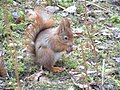 Red squirrel feeding
 -
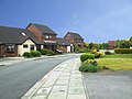 Housing in Formby
 -
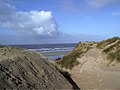 Formby beach sand dunes


References
- ^ The Boundary Committee for England (BCFE) began reviewing the electoral arrangements of Sefton on 4 December 2001.
- ^ a b c d e Farrer, William & Brownbill, J (1907). A History of the County of Lancaster: Volume 3. Victoria County History. pp. 45–52.
{{cite book}}: CS1 maint: multiple names: authors list (link) The Section dedicated to Formby. - ^ Wilson, John Marius (1874). Imperial Gazetteer of England and Wales (1870-1872). A. Fullarton & Co.
- ^ Tom Briwstow (2011-09-20). "Formby's fury at Boundary Commission plans to tear village in two". FormbyTimes.co.uk.
- ^ a b c "Formby, Ainsdale & Birkdale - Inspector Jim Atherton profile". Merseyside Police.
- ^ a b "City Relationships: Economic Linkages in Northern city regions. Liverpool City Region" (PDF).
- ^ "Sefton Council Core Strategy Options Paper May 2011. Profile of Sefton" (PDF).
- ^ Carolyn Garlick. "Formby coastal walk". BBC.co.uk.
- ^ "Formby". The National Trust.
- ^ The Sands Of Times, an introduction to the Sand Dunes of the Sefton Coast Line, written by Philip H. Smith. ISBN 1-902700-03-1
- ^ Smith, Philip H. (1999). The Sands of Time: an introduction to the Sand Dunes of the Sefton Coast. National Museums and Galleries on Merseyside. ISBN 1-902700-03-1.
- ^ Viking Mersey, written by Stephen Harding. ISBN 1-901231-34-8
- ^ Southport.TV
- ^ (FCS) Formby Civic Society
- ^ Larn, Richard. Wreck & Rescue Round the Cornish coast. Redruth: Tor Mark Press. p. 48. ISBN 978 085025 406 8.
{{cite book}}: Unknown parameter|coauthors=ignored (|author=suggested) (help) - ^ PDF file Handout issed by Seftom MBC and Mersey Travel
- ^ Yorke, Barbara & Reginald. Britain's First Lifeboat Station, Formby, 1776 - 1918. Alt Press. ISBN 0-9508155-0-0.
- ^ * The Squadrons of the Royal Air Force 1918-1988, J.J. Halley, Air-Britain, Tonbridge, 1988, ISBN 0-85130-164-9
- ^ Mersey Reporter History Section
- ^ Merseyside Police
- ^ Aeroflight - UK Police Aviation
- ^ Mersey Reporter History Page
- ^ "A Fantastic Weekend For ALL The Family!". Woodvale Rally. Retrieved 2011-12-13.
- ^ # The Sands Of Times, an introduction to the Sand Dunes of the Sefton Coast Line, written by Philip H. Smith. ISBN 1-902700-03-1
- ^ BBC
- ^ Formby Times
- ^ schoolswebdirectory.co.uk
- ^ National Trust
- ^ NM BAP Action Plan
- ^ Country File, BBC TV, 28.89.2008
- ^ Coastlines
- ^ Local Pager Report
- ^ UK Golf Info. website
- ^ Southport Reporter Obituary http://www.southportreporter.com/226/226-16.shtml
- ^ Formby Times http://www.formbytimes.co.uk/formby-sport/2009/01/21/fjsc-celebrates-its-50th-anniversary-this-month-phil-kirkbride-looks-back-66401-22735744
- ^ Liverpool Echo http://www.liverpoolecho.co.uk/liverpool-news/local-news/2004/09/17/junior-jim-a-real-marvel-100252-14653277
- ^ Formby FC Juniors
- ^ Local Paper
- ^ "Liverpool: richest street - Revealed: UK's poorest and richest streets - Pictures - Homefamily". Virgin Media. Retrieved 2011-12-13.
- ^ Knowhere Guide
- ^ St Luke's Church Website
- ^ BBC
External links
History
Media
- Radio City (local radio station)
- Formby Champion (free local newspaper)
- Liverpool Echo (local newspaper)
- Formby Reporter (free local newspaper)
- Formby Times (free local newspaper)
Information
- City Relationships: Economic Linkages in Northern city regions. Liverpool City Region
- Sefton Coast Metropolitan Borough of Sefton's website]
- Profile of Sefton
- Formby station timetable from National Rail's Live Departure Boards
Community
- Formby Community Plan
- Formby Community website
- Parish Church of St. Luke: History
- Photos of Formby Point
- Photos of St. Michael Church just outside Formby in Great Altcar.
- MOD Film locations page.
| Metropolitan districts | |
|---|---|
| Major settlements (cities in italics) | |
| Rivers | |
| Topics | |