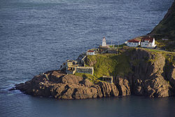
Fort Amherst, St. John's
Fort Amherst | |
|---|---|
Neighbourhood | |
 Fort Amherst from Signal Hill | |
 | |
| Country | |
| Province | |
| City | St. John's |
| Ward | 2 |
| Government | |
| • Administrative body | St. John's City Council |
| • Councilor | Frank Galgay |
| Official name | Fort Amherst National Historic Site of Canada |
| Designated | 1951 |
Fort Amherst is a neighbourhood in St. John's, Newfoundland and Labrador. It is located at 47°33′48.96″N 52°40′49.60″W / 47.5636000°N 52.6804444°W, on the southern side of the Narrows, the entrance to St. John's harbour. Apart from some family dwellings, Fort Amherst consists of a man-made harbour,[1] a lighthouse[2] and the remains of gun emplacements and pillboxes built during World War II to defend against German U-boats. Two QF 4.7-inch B Mark IV* guns remain in place, and can still be seen on their mountings.[3]

The original fortifications at Fort Amherst, built in the 1770s, are no longer visible.[3] The fortifications were named for William Amherst,[4] who successfully recaptured St. John's from French forces in 1762.[5] The site was designated a National Historic Site of Canada in 1951.[6]
The name is shared with Port La-Joye / Fort Amherst in Prince Edward Island and Fort Amherst in England.
The first lighthouse in Newfoundland was built at Fort Amherst in 1810.[7] The current lighthouse was built in 1951.[2]
See also
References
- ^ "Fort Amherst small boat harbor". Retrieved 2007-08-27.
- ^ a b "Fort Amherst lighthouse". Retrieved 2007-08-27.
- ^ a b "Fort Amherst history". Retrieved 2007-08-27.
- ^ "The Grand Concourse: Plans Presented for Fort Amherst". Retrieved 2009-08-16.
- ^ "The Recapture of St. John's, Newfoundland in 1762". Retrieved 2008-05-07.
- ^ Fort Amherst. Canadian Register of Historic Places. Retrieved 8 July 2012.
- ^ "Historic sites around St.Johns". Retrieved 2007-08-27.
