
Haripur Upazila
Haripur
হরিপুর | |
|---|---|
| Country | |
| Division | Rangpur Division |
| Area | |
| • Total | 201.06 km2 (77.63 sq mi) |
| Population (1991) | |
| • Total | 101,658 |
| • Density | 510/km2 (1,300/sq mi) |
| Time zone | UTC+6 (BST) |
| Website | Official Map of Haripur |
Haripur (Bengali: হরিপুর) is an Upazila of Thakurgaon District in the Division of Rangpur, Bangladesh.[1]
Geography
Haripur is located at 25°48′30″N 88°08′30″E / 25.8083°N 88.1417°E . It has 19559 households and total area 201.06 km².
Demographics
As of the 1991 Bangladesh census, Haripur has a population of 101658. Males constitute 50.93% of the population, and females 49.07%. This Upazila's eighteen up population is 49922. Haripur has an average literacy rate of 19.5% (7+ years), and the national average of 32.4% literate.[2]
Administration
Haripur has 6 Unions/Wards, 75 Mauzas/Mahallas, and 70 villages.
Gallery
-
 Amai Pond at Haripur Upazila parishad
 -
 Haripur King's palace
 -
 Haripur Pilot High School
 -
 Haripur Girls high school
 -
 Nagor River at Indo-Bangladesh Border
 -
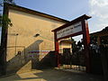
 Haripur Upazilla Parishad entrance


See also
References
- ^ Md. Abdul Gaffar (2012), "Haripur Upazila", in Sirajul Islam and Ahmed A. Jamal (ed.), Banglapedia: National Encyclopedia of Bangladesh (Second ed.), Asiatic Society of Bangladesh
- ^ "Population Census Wing, BBS". Archived from the original on 2005-03-27. Retrieved November 10, 2006.
| Upazila/Thana: | ||
|---|---|---|
Capital: Rangpur | ||
| Dinajpur District |  | |
| Gaibandha District | ||
| Kurigram District | ||
| Lalmonirhat District | ||
| Nilphamari District | ||
| Panchagarh District | ||
| Rangpur District | ||
| Thakurgaon District | ||
This Rangpur Division location article is a stub. You can help Wikipedia by expanding it. |