
Iacobeni, Sibiu
Iacobeni
Jakobsdorf | |
|---|---|
 Iacobeni (Jakobsdorf) | |
 Coat of arms | |
 Location in Sibiu County | |
 Iacobeni Location in Romania | |
| Coordinates: 46°3′N 24°43′E / 46.050°N 24.717°E | |
| Country | Romania |
| County | Sibiu |
| Government | |
| • Mayor (2020–2024) | Ioan Maca (PSD) |
| Area | 103.45 km2 (39.94 sq mi) |
| Elevation | 480 m (1,570 ft) |
| Population (2021-12-01)[1] | 2,780 |
| • Density | 27/km2 (70/sq mi) |
| Time zone | EET/EEST (UTC+2/+3) |
| Postal code | 557105 |
| Area code | (+40) 02 69 |
| Vehicle reg. | SB |
| Website | comuna-iacobeni |
Iacobeni (German: Jakobsdorf; Hungarian: Jakabfalva) is a commune located in Sibiu County, Transylvania, Romania.
At the 2011 Romanian census, 60.2% of inhabitants were Romanians, 35.8% Roma, and 1.3% Germans (more specifically Transylvanian Saxons). At the 1930 census, 59% were Germans, 40.1% Romanians, and 0.9% Hungarians.
Villages[edit]
The commune is composed of five villages: Iacobeni, Movile (formerly Hundrubechiu), Netuș, Noiștat, and Stejărișu (formerly Proștea). Each of them has a fortified church.
| In Romanian | In German | In Hungarian |
|---|---|---|
| Iacobeni | Jakobsdorf | Jakabfalva |
| Movile | Hundertbücheln | Százhalom |
| Netuș | Neithausen | Netus |
| Noiștat | Neustadt | Újváros |
| Stejărișu | Probstdorf | Prépostfalva |
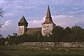
Movile[edit]
Movile is a village noted for its medieval fortifications constructed by German immigrants at the behest of the Hungarian King in the 12th and 13th centuries.
In 1910 the population was 247 Saxons. Movile was part of Austria-Hungary until 1918, when it was transferred to Romania. By 1992, all of the Germans had left and the population was made up of 347 ethnic Romanians.
-
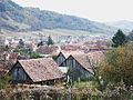 Overview of Iacobeni
 -
 St. Michael's Church in Movile
 -
 Fortified church of Iacobeni village
 -
 Fortified church of Movile
 -
 Fortified church of Movile
 -
 Fortified church of Netuș village


References[edit]
External links[edit]
- (in Romanian) "Movile" information and photographs
