
Inishturk
 Inishturk | |
| Geography | |
|---|---|
| Location | Atlantic Ocean |
| Coordinates | 53°42′05″N 10°06′30″W / 53.7014°N 10.1083°W |
| Highest elevation | 189.3 m (621.1 ft) |
| Administration | |
| Demographics | |
| Population | 58 |
| Pop. density | 221/km2 (572/sq mi) |
Inishturk (Inis Toirc in Irish, meaning Wild Boar Island) is an inhabited island of County Mayo, in Ireland.[2]
Geography

The island lies about 15 km (9 mi) off the coast; its highest point reaches 189.3 m (621.1 ft) above sea level.[1] Between Inisturk and Clare Island lies Caher Island. It has a permanent population of 58 people.[3] There are two main settlements, both on the more sheltered eastern end of the island, Ballyheer and Garranty. Bellavaun and Craggy are abandoned settlements. The British built a Martello tower on the western coast during the Napoleonic Wars. Inisturk has the highest per capita donation rate towards the RNLI in the whole of Ireland.[citation needed]
History
Inishturk has been inhabited on and off since 4,000 BCE and has been inhabited permanently since at least 1700.[4] Some of the more recent inhabitants are descended from evacuees from Inishark to the southwest[citation needed]. The social club Mountain Common is situated on the hill that separates the two settlements.
Recent history
In 1993 Inishturk Community centre was opened, this community centre doubles as a library and a pub.
In June 2014 the ESB commissioned three new Broadcrown BCP 110-50 100kVA diesel generators to supply electricity to the island[5] The ESB have operated a diesel power station on the island since the 1980s[6]
Inishturk gained international attention in 2016 after a number of websites claimed that the island would welcome any American "refugees" fleeing a potential Donald Trump presidency.[7][8][9] These claims were used as one example of the type of "fake news" that arose during the 2016 US presidential election campaign.[10] As of November 2016, no changes to inward migration have been reported.[citation needed]
Demographics
The table below reports data on Inisturk's population taken from Discover the Islands of Ireland (Alex Ritsema, Collins Press, 1999) and the Census of Ireland.
|
|
| |||||||||||||||||||||||||||||||||||||||||||||||||||||||||||||||||||||||||||||||||
| Source: Central Statistics Office. "CNA17: Population by Off Shore Island, Sex and Year". CSO.ie. Retrieved October 12, 2016. | |||||||||||||||||||||||||||||||||||||||||||||||||||||||||||||||||||||||||||||||||||
Transport
Prior to 1997 there was no scheduled ferry service and people traveled to and from the islands using local fishing boats. Since then a ferry service operates from Roonagh Quay, Louisburgh, County Mayo.[11] The pier was constructed during the 1980s by the Irish government, around this time the roads on the island were paved.[12]
Gallery
-
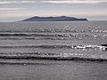 Inisturk and Caher island
 -
 Inishturk pier
 -
 Harbour with Caher Island in background
 -
 Community centre
 -
 Freshwater lake
 -
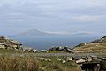 Clare Island as seen from Inishturk
 -
 Power station


See also
References
- ^ a b "Inisturk". MountainViews. Ordnance Survey Ireland. Retrieved February 23, 2015.
- ^ Sometimes the island's name is reported as Inisturk, as for instance by Google Maps
- ^ http://www.breakingnews.ie/ireland/no-christmas-medical-cover-on-island-of-inishturk-655775.html
- ^ Mayo Walks - Inishturk
- ^ BC Inishturk case study
- ^ New hope for Inishturk
- ^ http://www.theatlantic.com/video/index/491813/the-tiny-irish-island-that-will-welcome-american-refugees/
- ^ Huffington Post - Looking to escape Donald Trump
- ^ Remote Irish island seeks American fleeing Donald Trump presidency
- ^ "Fake news is big business - and may have handed Trump the election". The Business Post. 20 November 2016.
{{cite web}}: Unknown parameter|subscription=ignored (|url-access=suggested) (help) - ^ islander committed to her community
- ^ Winter Inishturk
External links
 Media related to Inishturk at Wikimedia Commons
- Podcast series on Mayo's Heritage, including a heritage Tour of Inishturk
- Mayo News - Inishturk islander committed to her community
- Island life Inishbofin Inishturk

This article related to the geography of County Mayo, Ireland is a stub. You can help Wikipedia by expanding it. |