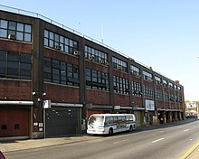
Jamaica Avenue


Jamaica Avenue is a major avenue in the New York City boroughs of Brooklyn and Queens, New York, in the United States. Jamaica Avenue's western end is at Broadway and Fulton Street, as a continuation of East New York Avenue, in Brooklyn's East New York neighborhood. Physically, East New York Avenue connects westbound to New York Avenue, where East New York Avenue changes names a second time to Lincoln Road; Lincoln Road continues to Ocean Avenue in the west, where it ends. Its eastern end is at the city line in Bellerose, Queens, where it becomes Jericho Turnpike to serve the rest of Long Island.
History
Jamaica Avenue was part of a pre-Columbian trail for tribes from as far away as the Ohio River and the Great Lakes, coming to trade skins and furs for wampum. It was in 1655 that the first settlers paid the Native Americans with two guns, a coat, and some powder and lead, for the land lying between the old trail and "Beaver Pond," later, Baisley Pond. Dutch Director-General Peter Stuyvesant dubbed the area "Rustdorp" in granting the 1656 land patent. The English, who took control of the colony 1664, renamed the little settlement "Jameco," for the Jameco (or Yamecah) Native Americans.
In the early 19th century the old road through Jamaica Pass was the Brooklyn Ferry Road, and at mid-century became the Brooklyn and Jamaica Plank Road with toll booths. Late in the century the portion west of Jamaica Pass became Fulton Street, and the eastern portion Jamaica Avenue.
Commerce
The part of Jamaica Avenue that runs through the heart of Jamaica, Queens is an important shopping street, and is on par with Brooklyn's Fulton Street. Prices are said to be low, in an exciting market place atmosphere. It is also the historic center of the former village with several city landmarks including the King Manor.
Jamaica Avenue is also the main shopping street for many other neighborhoods it runs through as well, including Woodhaven, Richmond Hill, and Queens Village.
Transportation
Jamaica Avenue is the starting point of many newer streets in Queens, such as Myrtle Avenue, Metropolitan Avenue, Hempstead Avenue, Guy R. Brewer Boulevard, Farmers Boulevard, and Queens Boulevard. Many bus lines run down Jamaica Avenue, most notably the Q56,[1] Q110,[2] and Q36.[3] The BMT Jamaica Line (J and Z trains) runs above Jamaica Avenue through the Cypress Hills section of Brooklyn along with Woodhaven and Richmond Hill. The Jamaica Bus Depot and East New York Bus Depot are located near the avenue.
Jamaica Avenue intersects as well with other former country roads in Queens which have become important urban streets, including Woodhaven Boulevard, Lefferts Boulevard, Sutphin Boulevard, Parsons Boulevard, Francis Lewis Boulevard, and Springfield Boulevard. Jamaica Avenue, from Alabama Avenue in East New York, Brooklyn to the Nassau County line, is 9.8 miles (15.8 km) long.
The Jamaica Center – Parsons/Archer subway terminal (E, J, and Z trains) with its associated bus station is a major transport hub, a rival to the nearby Jamaica – 179th Street station (E, F, and <F> trains) on Hillside Avenue.
References
External links
- A Walk down Jamaica Avenue Photoessay
- Jamaica Plank Road - Jamaica Avenue (Richmond Hill Historical Society)
