Karelia

Karelia (Karelian and Finnish Karjala; Template:Lang-ru, Kareliya; Template:Lang-sv), the land of the Karelian peoples, is an area in Northern Europe of historical significance for Finland, Russia, and Sweden. It is currently divided between the Russian Republic of Karelia, the Russian Leningrad Oblast, and Finland (the regions of South Karelia and North Karelia).
Use of name
Various subdivisions may be called Karelia. Finnish Karelia was a historical province of Finland, now divided between Finland and Russia, often called just Karjala in Finnish. The eastern part of this chiefly Lutheran area was ceded to Russia after the Winter War of 1939-40. This area is the "Karelia" of the Karelian question in Finnish politics.
The Republic of Karelia is a Russian federal subject, including the so-called "East Karelia" with a chiefly Russian Orthodox population.
Within present-day Finland, Karjala refers to regions of South and North Karelia.
History

Karelia was bitterly fought over by Sweden and the Novgorod Republic since the 13th-century Swedish-Novgorodian Wars. The Treaty of Nöteborg (Finnish: Pähkinäsaaren rauha) in 1323 divided Karelia between the two. Viborg (Finnish: Viipuri) became the capital of the new Swedish province.
The Treaty of Nystad (Finnish: Uudenkaupungin rauha) in 1721 between Imperial Russia and Sweden ceded most of Karelia to Russia. After Finland had been occupied by Russia in the Finnish War, parts of the ceded provinces (Old Finland) were incorporated into the Grand Duchy of Finland. In 1917 Finland became independent and the border was confirmed by the Treaty of Tartu in 1920.
During the 1920s, Finns were involved in attempts to overthrow the Bolshevists in Russian Karelia (East Karelia), for instance in the failed Aunus expedition. These mainly private expeditions ended after the peace treaty of Tartu. After the end of the Russian Civil War, and the establishment of the Soviet Union in 1922, the Russian part of Karelia became the Karelian Autonomous republic of the Soviet Union (ASSR) in 1923.
In 1939 the Soviet Union attacked Finland starting the Winter War. The Moscow Peace Treaty of 1940 handed most of Finnish Karelia to the Soviet Union. About 400,000 people, virtually the whole population, had to be relocated within Finland. In 1941 Karelia was re-conquered for three years during the Continuation War 1941–1944 when East Karelia was also occupied by the Finns. The Winter War and the resulting Soviet expansion caused considerable bitterness in Finland, which lost its second biggest city, Viipuri, its industrial heartland along the river Vuoksi, the Saimaa canal that connected central Finland to the Gulf of Finland, access to the fishing waters of Lake Ladoga (Finnish: Laatokka), and made an eighth of her citizens refugees without chance of return.
As a consequence of the peace treaty, the Karelian ASSR was incorporated with the Karelo-Finnish SSR 1941–1956, after which it became an ASSR again. Karelia was the only Soviet republic that was "demoted" from an SSR to an ASSR within the Russian SFR. Unlike autonomous republics, Soviet republics (in theory) had the constitutional right to secede. The possible fear of secession, as well as the Russian ethnic majority in Karelia may have resulted in its "demotion." In 1991 the Republic of Karelia was created out of the ASSR.
The collapse of the Soviet Union brought an economic collapse. After the dissolution of the Soviet Union, the area has experienced massive urban decay. The hastily and poorly constructed buildings from the Soviet era, as well as older houses remaining from the Finnish era, are being abandoned.[1]
Politics

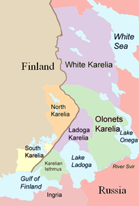
Karelia is divided between Finland and Russia. The Republic of Karelia is a republic of Russia, which was formed in 1991 from the Karelian ASSR. The Karelian Isthmus belongs to the Leningrad Oblast. The Finnish parts of Karelia are part of the regions (maakunta) of South Karelia and North Karelia.
There are some small but enthusiastic groups of Finns campaigning for closer ties between Finland and Karelia. The political expression of these irredentist hopes is called the Karelian question and is about Finland's re-acquisition of the ceded Finnish Karelia. These hopes live on, for instance, in the Karjalan Liitto and ProKarelia. These ambitions for closer ties with East Karelia do not include territorial demands. However, much of the original Finnish population of the Russian side of Karelia has been either resettled and integrated to inner Finland, Russified or dispersed into Russia as victims of Soviet internal population transfers.
Geography


Karelia stretches from the White Sea coast to the Gulf of Finland. It contains the two largest lakes in Europe, Lake Ladoga and Lake Onega. The Karelian Isthmus is located between the Gulf of Finland and Lake Ladoga.
The border between Karelia and Ingria, the land of the closely related Ingrian people, has originally been the Neva river itself but later on it was moved northward into Karelian isthmus to follow the Sestra River/Rajajoki (Template:Lang-ru), today in the Saint Petersburg metropolitan area, but in 1812–1940 the Russo-Finnish border.
On the other side of Lake Ladoga, River Svir is usually thought of as the traditional southern border of Karelian territory, as Lake Saimaa marks the Western border while Lake Onega and the White Sea mark the Eastern border. In the North there were the nomadic Samis, but no natural border except for huge woods (taiga) and tundra.
In historical texts Karelia is sometimes divided into East Karelia and West Karelia, which are also called Russian Karelia and Finnish Karelia respectively. The area to the north of Lake Ladoga which belonged to Finland before World War II is called Ladoga Karelia, and the parishes on the old pre-war border are sometimes called Border Karelia. White Karelia is the northern part of East Karelia and Olonets Karelia is the southern part.
Tver Karelia denotes the villages in the Tver Oblast that are inhabited by Karelians.
Inhabited localities


- Republic of Karelia
- Petrozavodsk (Петрозаводск, Petroskoi)
- Belomorsk (Беломорск, Sorokka)
- Medvezhyegorsk (Медвежьегорск, Karhumäki)
- Kalevala (Калевала, Uhtua)
- Kem (Кемь, Vienan Kemi, compare with Kemi)
- Kostomuksha (Костомукша, Kostamus)
- Kondopoga (Кондопога, Kontupohja)
- Sortavala (Сортавала, Sortavala, Sordavala)
- Segezha (Сегежа, Sekehe)
- Pitkyaranta (Питкяранта, Pitkäranta)
- Olonets (Олонец, Aunus)
- Karelian Isthmus
- South Karelia
- Imatra
- Joutseno
- Lappeenranta (Villmanstrand)
- North Karelia
Demographics
The Karelian language is spoken in the Republic of Karelia and also in the Tver Karelian villages. The Veps language is spoken on both sides of the River Svir. The so called Karelian dialects spoken mainly in Finnish South Karelia form the southeastern dialect group of Finnish. Similar dialects are also spoken in Ingria, which is an area between the Estonian border and Lake Ladoga. They appeared there in the 17th century after the Swedish conquest of the area. The older inhabitants of the Ingria, the Ingrians, have their own language which is related to the Karelian language and the south-eastern dialects of Finnish. [1] The dialects in Finnish North Karelia belong to the large group of Savonian dialects in Eastern and Central Finland. [2] Karelians who evacuated from Finnish Karelia resettled all over Finland and today there are approximately one million people in Finland having their roots in the area ceded to the Soviet Union after the World War II. In Finland, about 5,000 people speak Karelian.
Culture
See also
- Karelia Suite, a collection of pieces by the composer Jean Sibelius
- Asbestos-Ceramic, a type of pottery made in Karelia and vicinity
- Karelianism, a cultural movement in the Grand Duchy of Finland
- Mastodon (band), they pay homage to Karelia on their new album Crack the Skye with the song Ghost of Karelia
- Viipurin Lauluveikot, a Finnish men choir founded 1897 in Vyborg, Finnish Karelia
Citations
General References
- "They Took My Father," by Mayme Sevander and Laurie Hertzel, a history of American Finns who emigrated to Soviet Karelia during the Great Depression.
External links
- Karelians (The Peoples of the Red Book)
- The Many Karelias - Virtual Finland
- Regional flag.[3]
- - goSaimaa.fi for information about Southern Karelia travel
- Pielis.ru - travel information about North Karelia region and City of Joensuu
