
Lavangen Municipality
Lavangen Municipality
Lavangen kommune Loabága suohkan | |
|---|---|
 Inner Lavangen | |
 Flag  Coat of arms | |
 Troms within Norway | |
 Lavangen within Troms | |
| Country | Norway |
| County | Troms |
| District | Midt-Troms |
| Administrative centre | Tennevoll |
| Government | |
| • Mayor (2011) | Erling Bratsberg (Sp) |
| Area | |
| • Total | 301.72 km2 (116.49 sq mi) |
| • Land | 296.20 km2 (114.36 sq mi) |
| • Water | 5.52 km2 (2.13 sq mi) |
| • Rank | #276 in Norway |
| Population (2012) | |
| • Total | 1,016 |
| • Rank | #404 in Norway |
| • Density | 3.4/km2 (9/sq mi) |
| • Change (10 years) | |
| Demonym | Lavangsværing[1] |
| Official language | |
| • Norwegian form | Neutral |
| Time zone | UTC+01:00 (CET) |
| • Summer (DST) | UTC+02:00 (CEST) |
| ISO 3166 code | NO-1920[3] |
| Website | Official website |
Lavangen (Northern Sami: 'Loabák') is a municipality in Troms county, Norway. The administrative centre of the municipality is the village of Tennevoll. Other villages in Lavangen include Fossbakken and Spansdalen (in the inland areas) and Kjeiprød, Røkenes, Låternes, Tennevoll, Hesjevika, Soløy, and Å (surrounding the fjord).
General information
Lavangen was established on 1 January 1907 when it was separated from the municipality of Ibestad. The initial population was 1,536. On 1 January 1964, Lavangen was merged into the neighboring municipality of Salangen. The merger was brief, however, because on 1 January 1977, the old Lavangen municipality (except for the Lavangsnes area) was made a separate municipality once again.[4]
Name
The municipality is named after the fjord (Old Norse: Laufangr). The first element is lauf which means "leaf" (here in the sense of 'birchwood') and the last element is angr which means "fjord".[5]
Coat-of-arms
The coat-of-arms is from modern times (1987). The arms are a canting of the name (which means leaf) since it shows three gold-colored birch leaves on a red background. The three leaves represent how the municipality was settled by Norwegians, Samis, and Kvens.[6]
Churches
The Church of Norway has one parish (sokn) within the municipality of Lavangen. It is part of the Indre Troms deanery in the Diocese of Nord-Hålogaland.
| Parish (Sokn) | Church Name | Location of the Church | Year Built |
|---|---|---|---|
| Lavangen | Lavangen Church | Soløy | 1891 |
Geography
The municipality encompasses the land around the Spansdalelva river valley and most of the area around the Lavangen fjord, south of the Astafjorden. The municipality borders Narvik (in Nordland county) to the south, Gratangen to the west, Salangen to the north, and Bardu to the east.
-
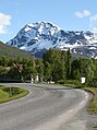 View of the mountain Spanstinden near Soløy
 -
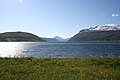 View of the Lanvangen fjord
 -
Map of the municipality
-
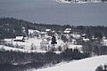 View of Skavmodalen


Climate
| Climate data for Tennevoll | |||||||||||||
|---|---|---|---|---|---|---|---|---|---|---|---|---|---|
| Month | Jan | Feb | Mar | Apr | May | Jun | Jul | Aug | Sep | Oct | Nov | Dec | Year |
| Mean daily maximum °C (°F) | −3.2 (26.2) |
−2.2 (28.0) |
1.1 (34.0) |
4.5 (40.1) |
10.1 (50.2) |
15.0 (59.0) |
17.2 (63.0) |
15.6 (60.1) |
10.6 (51.1) |
4.8 (40.6) |
0.6 (33.1) |
−1.2 (29.8) |
6.1 (43.0) |
| Daily mean °C (°F) | −6.7 (19.9) |
−5.8 (21.6) |
−2.9 (26.8) |
1.2 (34.2) |
6.6 (43.9) |
10.9 (51.6) |
13.3 (55.9) |
12.0 (53.6) |
7.1 (44.8) |
2.4 (36.3) |
−2.4 (27.7) |
−5.0 (23.0) |
2.6 (36.7) |
| Mean daily minimum °C (°F) | −11.5 (11.3) |
−10.2 (13.6) |
−7.4 (18.7) |
−3.4 (25.9) |
1.4 (34.5) |
6.4 (43.5) |
8.9 (48.0) |
7.5 (45.5) |
3.0 (37.4) |
−1.7 (28.9) |
−6.4 (20.5) |
−8.9 (16.0) |
−1.9 (28.6) |
| Average precipitation mm (inches) | 80 (3.1) |
81 (3.2) |
60 (2.4) |
53 (2.1) |
38 (1.5) |
59 (2.3) |
69 (2.7) |
76 (3.0) |
92 (3.6) |
113 (4.4) |
88 (3.5) |
91 (3.6) |
910 (35.8) |
| Average precipitation days (≥ 1 mm) | 11.2 | 11.8 | 10.1 | 9.3 | 8.5 | 10.9 | 12.8 | 14.8 | 14.6 | 14.7 | 12.0 | 12.0 | 142.7 |
| Source: Norwegian Meteorological Institute[7] | |||||||||||||
Government
All municipalities in Norway, including Lavangen, are responsible for primary education (through 10th grade), outpatient health services, senior citizen services, unemployment and other social services, zoning, economic development, and municipal roads. The municipality is governed by a municipal council of elected representatives, which in turn elect a mayor.
Municipal council
The municipal council (Kommunestyre) of Lavangen is made up of 15 representatives that are elected to every four years. Currently, the party breakdown is as follows:[8]
| Party name (in Norwegian) | Number of representatives | |
|---|---|---|
| Labour Party (Arbeiderpartiet) | 5 | |
| Progress Party (Fremskrittspartiet) | 1 | |
| Conservative Party (Høyre) | 3 | |
| Centre Party (Senterpartiet) | 6 | |
| Total number of members: | 15 | |
Attractions
Spanstind rundt is a famous cross-country skiing race in Lavangen that is held on Maundy Thursdays each year.
References
- ^ "Navn på steder og personer: Innbyggjarnamn" (in Norwegian). Språkrådet.
- ^ "Forskrift om målvedtak i kommunar og fylkeskommunar" (in Norwegian). Lovdata.no.
- ^ Bolstad, Erik; Thorsnæs, Geir, eds. (2023-01-26). "Kommunenummer". Store norske leksikon (in Norwegian). Kunnskapsforlaget.
- ^ Jukvam, Dag (1999). "Historisk oversikt over endringer i kommune- og fylkesinndelingen" (PDF) (in Norwegian). Statistisk sentralbyrå.
- ^ Rygh, Oluf (1911). Norske gaardnavne: Troms amt (in Norwegian) (17 ed.). Kristiania, Norge: W. C. Fabritius & sønners bogtrikkeri. p. 36.
- ^ Store norske leksikon. "Lavangen" (in Norwegian). Retrieved 2010-04-08.
- ^ "eKlima Web Portal". Norwegian Meteorological Institute.
- ^ "Table: 04813: Members of the local councils, by party/electoral list at the Municipal Council election (M)" (in Norwegian). Statistics Norway. 2015.
External links
 Media related to Lavangen at Wikimedia Commons
 The dictionary definition of lavangen municipality at Wiktionary
- Municipal fact sheet from Statistics Norway
 Troms travel guide from Wikivoyage
| |||||||
 | Towns and cities | ||||||
| Municipalities |
| ||||||
| |||||||