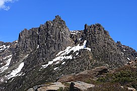
Mount Ossa (Tasmania)
| Mount Ossa | |
|---|---|
 Mount Ossa pictured in 2009 | |
| Highest point | |
| Elevation | 1,617 m (5,305 ft)[1] |
| Prominence | 1,617 m (5,305 ft)[1] |
| Isolation | 524 km (326 mi)[1] |
| Listing | Ultra[1] State high point |
| Coordinates | 41°52′12″S 146°01′48″E / 41.87000°S 146.03000°E[2] |
| Geography | |
Location in Tasmania | |
| Location | Central Highlands of Tasmania, Australia |
| Parent range | Pelion Range |
| Geology | |
| Rock age | Jurassic |
| Mountain type | Dolerite |
| Climbing | |
| Easiest route | 3½ hour return from Pelion Gap via the Overland Track |
Mount Ossa is a mountain of the Pelion Range located in the Central Highlands region of Tasmania, Australia.
With an elevation of 1,617 metres (5,305 ft) above sea level, Mount Ossa is the highest peak in Tasmania.[3] The mountain lies in the heart of Cradle Mountain-Lake St Clair National Park.
It was first surveyed by Charles Gould and named after Mount Ossa in Greece following the theme of classical greek names set by George Frankland, an early Tasmanian surveyor.[4][5] The entire mountain is composed of Jurassic dolerite.[6]
Ascending
The peak is fairly remote from the nearest road, however there is a well worn track from the Pelion Gap to the summit. Mt Ossa is a common side trip on the Overland Track from New Pelion Hut to Kia Ora Hut. The mountain can also be accessed by the Arm River Track. Conditions can be very severe in winter, with powerful winds and freezing temperatures. A short scramble is required to ascend the summit.[1]
The lower slopes are bushy but towards the summit the rocks are mostly bare. The walk to the summit from The Overland Track during summer usually features an array of beautiful wild flowers common in the area.
See also
References
- ^ a b c d e "Mount Ossa, Australia". Peakbagger.com. Retrieved 2 February 2014.
- ^ "Mount Ossa". Gazetteer of Australia online. Geoscience Australia, Australian Government.
- ^ "LISTmap (Mount Ossa)". Tasmanian Government Department of Primary Industries and Water. Retrieved 19 June 2007.
- ^ "Mount Ossa". UTas.
- ^ "Frankland, George (1800–1838)". Australian Dictionary of Biography.
- ^ I.B. Jennings. "Geology of the Cradle Mountain Reserve" (PDF). Economic and General Geology.
External links


