Mud Island, Memphis
This article needs additional citations for verification. (November 2011) |

Mud Island (not actually an island) is a small peninsula, surrounded by the Mississippi River to the west and the Wolf River Harbor to the east. In 1960, the Wolf River was diverted so that it flows into the Mississippi River north of Mud Island. Mud Island River Park, located on the south end of the island, opened to the public in 1982. It is located within the Memphis city limits, 1.2 miles from the coast of downtown, and houses a museum, restaurants, and an amphitheater. It is accessible by the Memphis Suspension Railway (a monorail), by foot (via a footbridge located on top of the monorail), by ferry, or automobile.
Mississippi River Park and Museum
Mississippi River Park

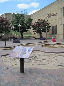
The Mississippi River park located on Mud Island[1] includes bike trails, pedal boats,[1] and rafts, as well as a hydraulic scale model of the lower Mississippi River from Cairo, Illinois to New Orleans.
Major cities and small towns located on the river are marked in the scale model, and markers explain history and facts about the river.
The model empties into a "Gulf of Mexico" replica which was once a waterpark named Bud Boogie Beach, and on the other side is a small wooden boat named the Maymay which is no longer open to the public. Admission to the park is free.
Mississippi River Museum

The museum on Mud Island presents the history of the lower Mississippi river valley, with great emphasis on the steamboat, complete with a full-scale replica steamboat.
An admission fee is charged for the museum.
Mud Island Amphitheatre
Mud Island is home to a 5,000 seat outdoor amphitheater[1] which has been used for a summer concert series for over two decades.
The band Dash Rip Rock, which has played there several times, recorded a song named Mud Island that can be found on two of their albums.
James Taylor, performing in the amphitheater during a light rainstorm in 1992, stuck his arm out into the falling water and remarked, "Mud Island... ominous name, eh?"[citation needed]
Harbor Town


The northern portion of Mud Island ("Harbor Town") features single-family homes and apartment complexes, and caters mostly to an affluent, younger crowd.
This section of the island includes the Mississippi River Trail, a grassy section of park land with running trails and benches overlooking the Mississippi River.
Wolf River Harbor was the lowermost channel of the Wolf River until 1960.
History
Downtown Airport
In 1959, the Memphis Downtown Airport was opened on Mud Island, which at that time was called City Island. The one-runway airport could be reached by a pontoon-boat ferry, made by Robert Ditto (principal of Kingsbury and Colonial Junior High), and was used mostly by businessmen and shoppers. The Downtown Airport was closed in 1970.[2]
See also
References
- ^ a b c Susanna Henighan Potter (1 April 2009). Moon Tennessee. Avalon Travel. p. 36. ISBN 978-1-59880-114-9. Retrieved 26 November 2011.
- ^ Bond, Beverly G.; Sherman, Janann (2003). Memphis: In Black & White. Memphis: Arcadia Publishing. p. 160. ISBN 0-7385-2441-7.


