Nakasongola Airport
Nakasongola Airport | |||||||||||
|---|---|---|---|---|---|---|---|---|---|---|---|
| Summary | |||||||||||
| Airport type | Military | ||||||||||
| Owner | Uganda People's Defence Force | ||||||||||
| Operator | UPDF | ||||||||||
| Serves | Nakasongola, Uganda | ||||||||||
| Location | Nakasongola, Uganda | ||||||||||
| Elevation AMSL | 3,710 ft / 1,130 m | ||||||||||
| Coordinates | 01°25′12″N 32°28′12″E / 1.42000°N 32.47000°E | ||||||||||
| Map | |||||||||||
 | |||||||||||
| Runways | |||||||||||
| |||||||||||
Nakasongola Airport (IATA: n/a, ICAO: n/a) is an airport in Uganda. As of June 2018, it was one of the 47 airports in the country.[1] It is the headquarters of the Air Wing of the Uganda People's Defense Force and is one of the five national military airports, namely Entebbe Airport, Gulu Airport, Jinja Airport, Soroti Airport and Nakasongola Airport.[2]
Location
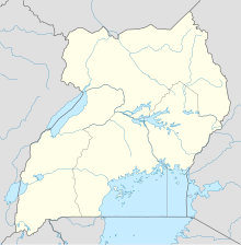
Nakasongola Airport is located in the neighborhood known as Wabisi, approximately 12 kilometres (7 mi), north of the town of Nakasongola, Nakasongola District, in the Central Region of Uganda.[3] It is located on the campus of Nakasongola Air Force Base, approximately 152 kilometres (94 mi), by air, directly north of Entebbe International Airport, the country’s largest civilian and military airport.[4] The geographic coordinates of Nakasongola Airport are:1°25′12″N 32°28′12″E / 1.42000°N 32.47000°E.[5]
Overview
Nakasongola Airport is a medium-sized military airport that serves the town of Nakasongola. It is the largest stand-alone military airport in Uganda. Nakasongola Airport is approximately 1,130 metres (3,710 ft) above sea level.[6] The airport has a single asphalt runway and taxiway that measure approximately 3,000 metres (9,800 ft) in length.[7]
The airport and the air base on which it is located were constructed by an Israeli company in the 1970s. As of June 2014[update], the airport was undergoing US$11 million (UGX:28 billion) renovations, following which the headquarters of the UPDF Air Force would relocate to Nakasongola to decongest Entebbe Air Force Base.[7][8][9]
See also
References
- ^ CIA (2018). "Uganda: Transportation: Airports". Washington, DC: CIA Factbook. Retrieved 10 June 2018.
- ^ Defenceweb (1 March 2014). "Uganda moving combat aircraft out of Entebbe". Johannesburg: Defenceweb.co.za. Retrieved 11 June 2018.
- ^ Globefeed.com (11 June 2018). "Distance between Post Bank, Nakasongola, Uganda and Nakasongola Airforce Base, Uganda". Globefeed.com. Retrieved 11 June 2018.
- ^ Globefeed.com (11 June 2018). "Air Distance between Entebbe International Airport, Entebbe, Uganda and Nakasongola Airforce Base, Uganda". Globefeed.com. Retrieved 11 June 2018.
- ^ "Location of Nakasongola Airport" (Map). Google Maps. Retrieved 11 June 2018.
- ^ Floodmap (11 June 2018). "Elevation of Nakasongola, Uganda". Floodmap.net. Retrieved 11 June 2018.
- ^ a b Binnie, Jeremy (25 February 2014). "UPDF Air Wing to move main base". London: Jane's Defence Weekly. Retrieved 11 June 2018.
{{cite web}}: Italic or bold markup not allowed in:|publisher=(help) - ^ Kasasira, Risdel (5 April 2014). "Works on Nakasongola UPDF Air Base Begin". Daily Monitor. Kampala. Retrieved 11 June 2018.
- ^ Candia, Steven (23 February 2014). "UPDF's Air Force To Move To Nakasongola". New Vision. Kampala. Retrieved 11 June 2018.


