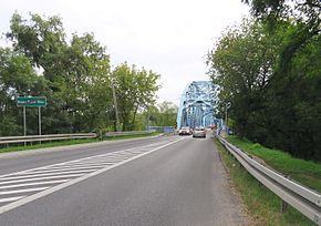
National road 85 (Poland)
Appearance
| National Road 85 | ||||
|---|---|---|---|---|
| [Droga krajowa nr 85] Error: {{Lang}}: text has italic markup (help) | ||||
 | ||||
 | ||||
| Route information | ||||
| Maintained by GDDKiA | ||||
| Length | 4.774 km (2.966 mi) | |||
| Major junctions | ||||
| From | Nowy Dwór Mazowiecki | |||
| see Route plan section | ||||
| To | Kazuń Polski | |||
| Location | ||||
| Country | Poland | |||
| Regions | Masovian Voivodeship | |||
| Major cities | Nowy Dwór Mazowiecki, Kazuń | |||
| Highway system | ||||
| ||||
Droga krajowa nr 85 (translates from Polish as national road 85) is route belonging to Polish national roads network. It runs through Masovian Voivodeships, leading from crossing with national road 62 in Nowy Dwór Mazowiecki to junction with expressway S7 near Kazuń Polski. With its entire length, national road 85 was the shortest of all Polish national roads until 1 January 2014 (now the shortest is national road 96).
Major towns along the route
- Nowy Dwór Mazowiecki (national road 62)
- Kazuń (S7)
Route plan
| km | Icon | Name | Crossed roads |
|---|---|---|---|
| 0 | Nowy Dwór Mazowiecki | Żołnierzy Września Street | |
| x | Roundabout in Nowy Dwór Mazowiecki | Chłodna and Kaszewskiego Streets | |
| x | Nowy Dwór Mazowiecki | Warsaw Street | |
| x | Nowy Dwór Mazowiecki | Wojska Polskiego Street | |
| x | Kazuń Polski | ||
| 4.774 | Kazuń interchange | ||
| x | |||
| x |
Wikimedia Commons has media related to National road 85 (Poland).

