Newman, Western Australia
This article needs additional citations for verification. (April 2008) |
| Newman Western Australia | |||||||||
|---|---|---|---|---|---|---|---|---|---|
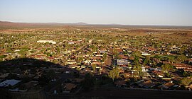
 Newman residential area | |||||||||
| Coordinates | 23°21′14″S 119°43′55″E / 23.35389°S 119.73194°E | ||||||||
| Population | 4,567 (2016 census)[1] | ||||||||
| Established | 1966 | ||||||||
| Postcode(s) | 6753 | ||||||||
| Elevation | 544 m (1,785 ft)[2] | ||||||||
| Location |
| ||||||||
| LGA(s) | Shire of East Pilbara | ||||||||
| State electorate(s) | Pilbara | ||||||||
| Federal division(s) | Durack | ||||||||
| |||||||||
Newman, originally named Mount Newman until 1981, is a town in the Pilbara region of Western Australia. It is located about 1,186 kilometres (737 mi) north of Perth, and 9 kilometres (5.6 mi) north of the Tropic of Capricorn. It can be reached by the Great Northern Highway. Newman is a modern mining town, with homes contrasting with the surrounding reddish desert. The Hickman Crater is 35 kilometres (22 mi) north of Newman.
History

Newman was established as Mount Newman by Mt. Newman Mining Co. Pty Ltd (a subsidiary of BHP) in 1966 as a company town to support the development of iron ore deposits at nearby Mount Whaleback.[4] The town takes its name from nearby Mount Newman, named in honour of government surveyor Aubrey Woodward Newman (son of Edward Newman who also died young) who died of typhoid aged 28 at Cue on 24 May 1896, while on an expedition from Nannine to the Ophthalmia Range. William Frederick Rudall then took charge of the expedition and named Mount Newman to honour his deceased leader.[5][6][7][8][9]
Aboriginal occupation of the area extends to around 45,000 years.[10] The Martu people comprise about a dozen language groups that extend across the Gibson and Great Sandy Deserts. The Martu progressively lost their land and nomadic lifestyle as European expansion crept inland from the late 19th Century. Western exploration, the establishment of Christian missions, and gold discoveries at Marble Bar and Wiluna led to Indigenous people moving from their traditional lands.
Commercial area and amenities

Typical of company towns, Newman is laid out with a core, where shopping and hotels are located, surrounded by residential areas, with more industrial activities on the outskirts. There are two supermarkets in town (one Woolworths and an IGA[11]), two shopping plazas, three hotels, and three bars/restaurants outside of those contained in the hotels. One public outdoor pool serves the town's population.
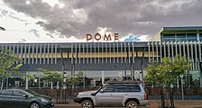
In late 2017, Parnawarri Retail centre (Parnawarri meaning "united" or "all together" in Nyiyaparli)[12] was opened and housed the towns second supermarket (IGA) as well as a Dome coffeehouse, SportsPower and a Chicken Treat. BHP invested $30 million to build the retail centre.[12]
The town contains Newman Primary School, South Newman Primary School, Newman Senior High School, and Rawa Community School.
Transport and infrastructure

Newman is located at the end of route 138 meeting the Great Northern Highway.
The town is served by Newman Airport.
A privately owned railway, the Mount Newman railway, was constructed linking it to Port Hedland which itself was upgraded to handle shipment of the ore to the world market. On 21 June 2001 a train 7.353 km (4.569 mi) long, comprising 682 ore cars and eight locomotives made the Newman—Port Hedland trip and is listed as the world's longest ever train.[13][14] The ore trains are typically over 2 km long. Newman is also a service town to the nearby mining settlements like Tom Price and Paraburdoo.
Electricity is supplied by Alinta from its 180 MW gas-fired power station with a 30MW/11MWh Kokam battery at Newman. The station also supplies the Roy Hill mine,[15] [16] with grid construction reaching the Cloudbreak and Christmas Creek mines.[17][18]
Architecture
Being founded in the 1960s, Newman's architecture reflects the modernist styles of that decade and the next, being predominantly functional and devoid of detail or embellishment. As the town was founded and built by a steel company, the majority of buildings use a steel frame construction. This applies to the homes themselves, most of them being two prefabricated halves inserted together into a steel I-section frame, the columns of which are left exposed on the exterior of the home. This construction method serves not only to showcase the company's product, but also gives strong resistance to cyclone winds which can affect the region from time to time. For this same reason most houses are elevated from the ground by a few steps. Many houses also have large air-conditioning units situated next to them to provide adequate cooling against the very hot summer temperatures.
Climate
Newman has a hot desert climate (Köppen climate classification BWh), with very hot summers and mild winters. The temperature reaches or exceeds 38 °C (100 °F) for many days in the summer. On 15 January 1998, the temperature reached an all-time recorded high of 47 °C (117 °F).
Precipitation is sparse, but the influx of monsoonal moisture in the summer, which generally begins in December and lasts until April, raises humidity levels and can cause occasional heavy storms. Winter months are mild to warm, with daily high temperatures ranging from the 20 °C (68 °F) to 26 °C (79 °F), and low (nighttime) temperatures rarely dipping below 6 °C (43 °F).
| Climate data for Newman (Newman Aero) | |||||||||||||
|---|---|---|---|---|---|---|---|---|---|---|---|---|---|
| Month | Jan | Feb | Mar | Apr | May | Jun | Jul | Aug | Sep | Oct | Nov | Dec | Year |
| Record high °C (°F) | 47.0 (116.6) |
46.0 (114.8) |
45.2 (113.4) |
40.9 (105.6) |
35.5 (95.9) |
33.0 (91.4) |
31.4 (88.5) |
34.3 (93.7) |
38.0 (100.4) |
42.9 (109.2) |
43.9 (111.0) |
46.7 (116.1) |
47.0 (116.6) |
| Mean daily maximum °C (°F) | 39.1 (102.4) |
37.3 (99.1) |
35.4 (95.7) |
32.1 (89.8) |
27.2 (81.0) |
23.0 (73.4) |
23.0 (73.4) |
26.1 (79.0) |
30.5 (86.9) |
35.2 (95.4) |
37.2 (99.0) |
39.2 (102.6) |
32.1 (89.8) |
| Mean daily minimum °C (°F) | 25.1 (77.2) |
24.0 (75.2) |
22.1 (71.8) |
17.6 (63.7) |
11.9 (53.4) |
7.4 (45.3) |
6.4 (43.5) |
7.9 (46.2) |
12.2 (54.0) |
17.7 (63.9) |
21.1 (70.0) |
24.0 (75.2) |
16.4 (61.5) |
| Record low °C (°F) | 15.8 (60.4) |
14.9 (58.8) |
9.0 (48.2) |
6.0 (42.8) |
1.0 (33.8) |
−1.1 (30.0) |
−2.0 (28.4) |
−2.0 (28.4) |
1.0 (33.8) |
6.0 (42.8) |
11.8 (53.2) |
15.2 (59.4) |
−2.0 (28.4) |
| Average precipitation mm (inches) | 66.9 (2.63) |
70.4 (2.77) |
42.6 (1.68) |
21.4 (0.84) |
18.6 (0.73) |
16.2 (0.64) |
14.2 (0.56) |
6.6 (0.26) |
3.8 (0.15) |
5.9 (0.23) |
12.8 (0.50) |
35.5 (1.40) |
329.5 (12.97) |
| Average precipitation days | 6.9 | 6.8 | 4.7 | 3.2 | 2.7 | 3.0 | 2.6 | 1.3 | 0.8 | 1.6 | 2.8 | 5.0 | 41.4 |
| Average afternoon relative humidity (%) | 25 | 34 | 28 | 29 | 27 | 32 | 29 | 22 | 17 | 14 | 15 | 20 | 24 |
| Source: [19] | |||||||||||||
See also
References
- ^ Australian Bureau of Statistics (27 June 2017). "Newman (Urban Centre/Locality)". 2016 Census QuickStats. Retrieved 5 January 2018.
- ^ Bureau of Meteorology
- ^ "Great Circle Distance between NEWMAN and MEEKATHARRA". Geoscience Australia. Archived from the original on 4 June 2011. Retrieved 18 February 2010.
- ^ "Part 3 -Newman" (PDF). Pilbara Vernacular Handbook. Perth, WA: LandCorp. p. 3. Retrieved 21 December 2016.
- ^ "Death of Mr. A. Newman". The West Australian. Perth, WA. 26 May 1896. pp. 4–5. Retrieved 20 December 2016.
- ^ "News in Brief". The Daily News. Perth, WA. 27 October 1896. p. 2. Retrieved 20 December 2016.
- ^ Smith, Eleanor Page (1966). The Beckoning West: The Story of H. S. Trotman and the Canning Stock Route. Sydney: Angus and Robertson. p. 62.
- ^ "The Government Exploration Party". The West Australian. Perth, WA. 12 August 1896. p. 3. Retrieved 21 December 2016.
- ^ "Supporting Local Communities in Western Australia" (PDF). Melbourne: BHP Billiton Limited. 4 April 2015. Retrieved 20 December 2016.
- ^ Slack, M.J., Law, W.B. and Gliganic, L.A., 2020. The early occupation of the Eastern Pilbara revisited: New radiometric chronologies and archaeological results from Newman Rockshelter and Newman Orebody XXIX. Quaternary Science Reviews, 236, p.106240.
- ^ "Parnawarri IGA, Newman - Lane Industries - Supermarket Shop Fitters". laneind.com.au. Retrieved 30 May 2018.
- ^ a b "Retail centre boost for town". The West Australian. 17 November 2017. Retrieved 30 May 2018.
- ^ Hamersley Freight Line, Australia railway-technology.com, accessed: 4 November 2010
- ^ BHP breaks its own heaviest train record Railway Gazette International, published: 1 August 2001, accessed: 5 November 2010
- ^ Parkinson, Giles (10 April 2018). "Kokam commissions 30MW battery to help supply Gina Rinehart mine". RenewEconomy. Archived from the original on 28 October 2020.
- ^ Parkinson, Giles (12 August 2019). "Alinta sees sub 5-year payback for unsubsidised big battery at Newman". RenewEconomy. Archived from the original on 10 October 2020.
- ^ "Chichester Project - Alinta Energy". alintaenergy.com.au. Archived from the original on 20 September 2020.
- ^ Parkinson, Giles (9 November 2020). "Biggest solar farm outside main grids nearly complete, miner counts huge savings". RenewEconomy. Archived from the original on 9 November 2020.
- ^ "BOM".
Further reading
- Austin, Noel (1999) The Newman story, 1967-1969. Publication details not known - held at Battye library, Perth, Western Australia
- DuBois, Lesley et al. (1994) Moving a mountain: an historic illustrated and photographic study of the town of Newman. Perth, Western Australia: L. DuBois
- Eckhart, Peter (1996) Whaleback tales. Carlisle, Western Australia: Hesperian Press. ISBN 0-85905-230-3
External links
![]() Media related to Newman, Western Australia at Wikimedia Commons
Media related to Newman, Western Australia at Wikimedia Commons

