
Oadby and Wigston
Borough of Oadby and Wigston | |
|---|---|
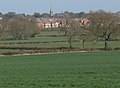
 Oadby, one of the two towns that form the borough | |
 Shown within Leicestershire | |
| Sovereign state | United Kingdom |
| Constituent country | England |
| Region | East Midlands |
| Administrative county | Leicestershire |
| Admin. HQ | Oadby |
| Government | |
| • Type | Oadby and Wigston Borough Council |
| • MPs: | Neil O'Brien |
| Area | |
| • Total | 9 sq mi (24 km2) |
| • Rank | 286th |
| Population (2022) | |
| • Total | 58,341 |
| • Rank | Ranked 291st |
| • Density | 6,300/sq mi (2,400/km2) |
| Ethnicity (2021) | |
| • Ethnic groups | |
| Religion (2021) | |
| • Religion | List
|
| Time zone | UTC+0 (Greenwich Mean Time) |
| • Summer (DST) | UTC+1 (British Summer Time) |
| ISO 3166-2 | GB-LEC |
| ONS code | 31UJ (ONS) E07000135 (GSS) |
| NUTS 3 | UKF22 |
Oadby and Wigston is a local government district with borough status in Leicestershire, England. It covers the two towns of Oadby, where the council is based, and Wigston, which is the larger town. Both form part of the Leicester urban area, lying south-east of the city.
The neighbouring districts are Leicester, Harborough and Blaby.
History[edit]
The district was created on 1 April 1974 under the Local Government Act 1972, covering the area of two former districts, which were both abolished at the same time:[2]
- Oadby Urban District
- Wigston Urban District
The new district was named Oadby and Wigston, combining the towns' names.[3] The new district was awarded borough status from its creation, allowing the chair of the council to take the title of mayor.[4]
Governance[edit]
Oadby and Wigston Borough Council | |
|---|---|
 | |
| Type | |
| Type | |
| History | |
| Founded | 1 April 1974 |
| Leadership | |
Anne Court since 2018 | |
| Structure | |
| Seats | 26 councillors |
 | |
Political groups |
|
Length of term | 4 years |
| Elections | |
Last election | 4 May 2023 |
Next election | 6 May 2027 |
| Meeting place | |
 | |
| Brocks Hill Council Offices, Washbrook Lane, Oadby, Leicester, LE2 5JJ | |
| Website | |
| www | |
Oadby and Wigston Borough Council provides district-level services. County-level services are provided by Leicestershire County Council. There are no civil parishes in the borough, which is an unparished area.[8][9]
Political control[edit]
The council has been under Liberal Democrat majority control since 1991.
The first election to the council was held in 1973, initially operating as a shadow authority alongside the outgoing authorities before coming into its powers on 1 April 1974. Political control of the council since 1974 has been as follows:[10][11]
| Party in control | Years | |
|---|---|---|
| Conservative | 1974–1991 | |
| Liberal Democrats | 1991–present | |
Leadership[edit]
The role of mayor is largely ceremonial in Oadby and Wigston. Political leadership is instead provided by the leader of the council. The leaders since 2006 have been:[12]
| Councillor | Party | From | To | |
|---|---|---|---|---|
| John Boyce | Liberal Democrats | 2006 | 18 Apr 2023 | |
| Samia Haq | Liberal Democrats | 18 Apr 2023 | ||
Composition[edit]
Following the 2023 election the composition of the council was:[13][14]
| Party | Councillors | |
|---|---|---|
| Liberal Democrats | 19 | |
| Conservative | 7 | |
| Total | 26 | |
The next election is due in 2027.
Elections[edit]

Since the last boundary changes in 2003 the council has comprised 26 councillors representing 10 wards, with each ward electing two or three councillors. Elections are held every four years.[15]
The wards are:
- Oadby Brocks Hill (2)
- Oadby Grange (3)
- Oadby St Peter's (2)
- Oadby Uplands (2)
- Oadby Woodlands (2)
- South Wigston (3)
- Wigston All Saints (3)
- Wigston Fields (3)
- Wigston Meadowscroft (3)
- Wigston St Walstan's (3)
The district forms part of the Harborough constituency.[9]
Premises[edit]
The council meets at the Brocks Hill Council Offices in Brocks Hill Park on Washbrook Lane in Oadby.

Until 2023 the council was based at Bushloe House on Station Road in Wigston, which had been built c. 1850 as a house and had been bought in 1942 by the old Wigston Urban District Council and converted to become its headquarters.[16][17] In 2023 the council moved its meetings and offices to the Brocks Hill offices in Oadby.[18]
Geography[edit]
It is composed of the areas of Oadby, Wigston, South Wigston and the hamlet of Kilby Bridge. It is predominantly urban, and borders Leicester directly to the north-west. There are no civil parishes in the district.
The most northerly corner is near the junction of the A6030 and B582, and near the Bupa hospital it meets Harborough. It runs along the B582 then along the former Roman road (which runs to Corby), passing the playing fields of the University of Leicester. It passes along the north edge of Oadby Lodge, a farm owned by the Co-op. Towards the deserted village of Stretton Magna (outside the district), the boundary passes southwestwards. This area was proposed to be the site of the eco-town Pennbury. It crosses the A6 at Glen Gorse Golf Club. It crosses Newton Lane and the Midland Main Line. It crosses the Grand Union Canal, and towards Kilby it meets the district of Blaby at the River Sence. It follows the River Sence, crossing the A5199 (Welford Road). At Rose Farm it follows Countesthorpe Road towards South Wigston, to the Grand Union Canal, crossing the former Midland Counties Railway, which it follows westwards. It passes northwards across St Thomas Road (B582) and the Birmingham to Peterborough Line. It passes northwards on the east side of the Glen Parva prison (in Blaby district). It meets Leicester UA south of Eyres Monsell, a large housing estate.
Following the Leicester boundary, it crosses Saffron Road (B5366), then follows Dorset Avenue, follows the Midland Main Line northwards, crossing Aylestone Lane (B5418), then crosses the Midland Main Line. It crosses the Welford Road (A5199) at the point where the road becomes a dual-carriageway south of the Best Western Leicester Stage Hotel (in Leicester UA). It passes on the south edge of Knighton Park, and the western edge of Oadby Golf Club, west of Leicester Racecourse (in the district). Near the racecourse entrance it crosses the A563 southern ring road, then London Road (A6), passing northwards along the western edge of the University of Leicester's Oadby Student Village, west of the University of Leicester Botanic Garden (in the district).
Demography[edit]
| Population growth in Oadby and Wigston | ||||||||||||
|---|---|---|---|---|---|---|---|---|---|---|---|---|
| Year | 1951 | 1961 | 1971 | 1981 | 1991 | 2001 | 2011 | 2016 | 2021 | 2031 | ||
| Population | 23,943 | 34,206 | 50,253 | 50,014 | 51,542 | 55,773 | 56,170 | 55,800 | 56,500 | 59,700 | ||
| Census [19] | ONS[20] | ONS Projections [21] | ||||||||||
Education[edit]
Both Beauchamp College, in the south of Oadby, and Wigston College, on the B582 in Wigston, are former grammar schools. Both were upper schools, as the three tier system operated in the district's schools. Also near the council offices on the B582 is South Leicestershire College, an FE college. Next to the Beauchamp College is Gartree High School, a former middle school. Another school is Manor High School, Oadby, which was the largest middle school in the country.
Coat of arms[edit]
|
Freedom of the borough[edit]
The following people, military units and Organisations have received the Freedom of the Borough of Oadby and Wigston.
Individuals[edit]
- H. Embacher: 1988.
Military units[edit]
- The Royal Anglian Regiment: 2011.
- B Squadron Leicestershire and Derbyshire Yeomanry, Royal Yeomanry: 17 April 2012.[23][24]
Organisations and groups[edit]
- The University of Leicester: 13 September 2021.[25][26][27]
Gallery[edit]
-
 Wigston Magna, one of the two towns that form the borough
 -
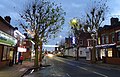
 South Wigston, the largest village in the borough
 -
 Brocks Hill Borough Council offices at Brocks Hill Country Park
 -
 Ash Tree Road in Oadby
 -
 Grand Union Canal - Kilby Bridge
 -
 South Wigston, Blaby Road


.jpg)
References[edit]
- ^ a b UK Census (2021). "2021 Census Area Profile – Oadby and Wigston Local Authority (E07000135)". Nomis. Office for National Statistics. Retrieved 5 January 2024.
- ^ "The English Non-metropolitan Districts (Definition) Order 1972", legislation.gov.uk, The National Archives, SI 1972/2039, retrieved 22 August 2022
- ^ "The English Non-metropolitan Districts (Names) Order 1973", legislation.gov.uk, The National Archives, SI 1973/551, retrieved 22 August 2022
- ^ "District Councils and Boroughs". Parliamentary Debates (Hansard). 28 March 1974. Retrieved 16 January 2012.
- ^ "Council minutes, 10 May 2022". Oadby and Wigston Borough Council. 10 May 2022. Retrieved 4 November 2023.
- ^ "Council minutes, 18 May 2023". Oadby and Wigston Borough Council. 18 May 2023. Retrieved 4 November 2023.
- ^ "Council minutes, 18 April 2023" (PDF). Oadby and Wigston Borough Council. Retrieved 4 November 2023.
- ^ "Local Government Act 1972", legislation.gov.uk, The National Archives, 1972 c. 70, retrieved 31 May 2023
- ^ a b "Election Maps". Ordnance Survey. Retrieved 17 October 2023.
- ^ "Compositions calculator". The Elections Centre. 4 March 2016. Retrieved 10 August 2022.
- ^ "Oadby & Wigston". BBC News Online. Retrieved 19 March 2010.
- ^ "Council minutes". Oadby and Wigston Borough Council. Retrieved 18 August 2022.
- ^ "Local elections 2023: live council results for England". The Guardian.
- ^ "Oadby and Wigston Borough Council".
- ^ "The Borough of Oadby and Wigston (Electoral Changes) Order 2002", legislation.gov.uk, The National Archives, SI 2002/2889, retrieved 4 November 2023
- ^ Historic England. "Bushloe House (Grade II) (1073658)". National Heritage List for England. Retrieved 4 November 2023.
- ^ "Wigston Urban District Council: Civic Centre and administrative offices". Leicester Evening Mail. 15 October 1942. p. 6. Retrieved 4 November 2023.
- ^ Moorhouse, Sam (12 July 2023). "Oadby and Wigston Borough Council unveils new £2.7 million office in country park". Leicestershire Live. Retrieved 4 November 2023.
- ^ Vision of Britain through time
- ^ mid year estimate
- ^ ONS population projections 2014 base
- ^ "East Midlands Region". Civic Heraldry of England. Retrieved 8 March 2021.
- ^ "Freedom of the Borough march to be held in Wigston". Leicester Mercury. 1 May 2012. Archived from the original on 12 September 2012.
- ^ "Freedom of the Borough".
- ^ "University of Leicester granted Honorary Freedom of the Borough". Oadby and Wigston Borough Council. Retrieved 12 July 2021.
- ^ "University of Leicester Granted Freedom of The Borough". In Your Area. 4 April 2021. Retrieved 12 July 2021.
- ^ "University of Leicester receives Freedom of the Borough honour". The University of Leicester. 13 September 2021. Retrieved 8 December 2023.
External links[edit]

| International | |
|---|---|
| National | |