Oakford, Indiana
Appearance
Oakford | |
|---|---|
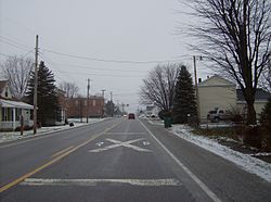
 Approaching the railroad crossing in Oakford | |
| Country | United States |
| State | Indiana |
| County | Howard |
| Township | Taylor |
| Elevation | 860 ft (260 m) |
| ZIP code | 46902 |
| FIPS code | 18-55584[1] |
| GNIS feature ID | 440462[2] |
Oakford (originally called Fairfield[3]) is an unincorporated community in southwestern Taylor Township, Howard County, Indiana, United States.
Oakford is part of the Kokomo, Indiana Metropolitan Statistical Area.
History
Oakford was laid out in 1852.[4] It was originally called Fairfield, and the name Oakford was adopted in 1854.[5]
Geography
Oakford lies at a railroad crossing of State Road 26, and little more than 1 mile (about 2 km) east of State Road 26's intersection with U.S. Route 31 until November 2013.[6] Now US 31 has been moved over, and Oakford is right at the State Road 26 exit (on the west side) on the new interstate grade Highway US 31.
It is located at 40°25′9″N 86°6′16″W / 40.41917°N 86.10444°W.
References
- ^ "American FactFinder". United States Census Bureau. Archived from the original on September 11, 2013. Retrieved 2008-01-31.
{{cite web}}: Unknown parameter|deadurl=ignored (|url-status=suggested) (help) - ^ "Oakford, Indiana". Geographic Names Information System. United States Geological Survey, United States Department of the Interior. Retrieved 2009-10-17.
- ^ Geographic Names Information System Feature Detail Report, Geographic Names Information System, 1979-02-14. Accessed 2008-01-07.
- ^ "Howard County's Townships and Their Early Settlements and Towns". Kokomo-Howard County Public Library. Retrieved 2 June 2014.
- ^ "A Look Back as We Move Forward". The Kokomo Tribune. March 28, 1999. p. 58. Retrieved August 16, 2014 – via Newspapers.com.

- ^ DeLorme. Indiana Atlas & Gazetteer. 3rd ed. Yarmouth: DeLorme, 2004, p. 33. ISBN 0-89933-319-2.

