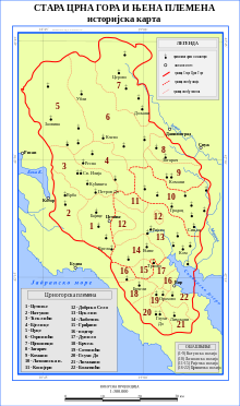
Old Montenegro
Appearance

Old Montenegro (Montenegrin/Serbian: Стара Црна Гора/Stara Crna Gora) is a term used for the embryonic part of modern Montenegro, the territory of the Prince-Bishopric of Montenegro and Principality of Montenegro (as recognised by the Congress of Berlin in 1878) prior to its expansion and eventual proclamation of a kingdom during the Balkan Wars. Before the consolidation of the Montenegrin state, in the Ottoman period (see also Montenegro Vilayet), Old Montenegro was made up of the Montenegrin tribes (Crnogorska plemena), simply known as Montenegrins (Crnogorci, as opposed to the Brđani, Hercegovci and Primorci). It included four territorial units, nahije: Katun, Rijeka, Lješanska nahija and Crmnica.
Tribes
Tribes, divided by nahija.
- Riječka nahija
- Katunska nahija (Katun)
- Lješanska nahija
- Draževina
- Gradac
- Buronje
- Crmnička nahija (Crmnica)
See also
