Pinckneyville (Union, South Carolina)
Appearance
Pinckneyville | |
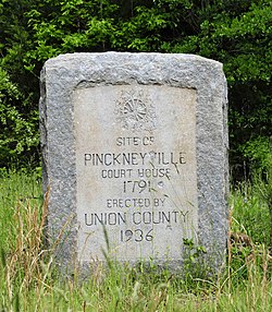
 Pinckneyville Monument, April 2012 | |
| Location | 13 miles northeast of Union on South Carolina Highway 13, near Union, South Carolina |
|---|---|
| Coordinates | 34°30′44″N 81°28′10″W / 34.51222°N 81.46944°W |
| Area | 1.8 acres (0.73 ha) |
| NRHP reference No. | 69000175[1] |
| Added to NRHP | December 3, 1969 |
Pinckneyville is a historic frontier settlement site located near Union, Union County, South Carolina. Pinckneyville was established on February 19, 1791 by the General Assembly of South Carolina Act #1491 along with the Washington district,[2] and is one of the earliest settlements in the South Carolina backcountry.
The property includes the original site of Pinckneyville and contains the ruins of the brick structure mistakenly referred to as the jail [3] and one other brick building, usually referred to as the old store.[4][5]
It was added to the National Register of Historic Places in 1969.[1]
References
- ^ a b "National Register Information System". National Register of Historic Places. National Park Service. July 9, 2010.
- ^ Carrillo, Richard. "Archeological Excavations at Pinckneyville, Site of Pinckney District, 1791-1800". http://scholarcommons.sc.edu/. University of South Carolina. Retrieved 17 August 2016.
{{cite web}}: External link in|website= - ^ Carrillo, Richard. "Archeological Excavations at Pinckneyville, Site of Pinckney District, 1791-1800". http://scholarcommons.sc.edu/. University of South Carolina. Retrieved 17 August 2016.
{{cite web}}: External link in|website= - ^ Mrs. James W. Fant (November 1968). "Pinckneyville" (pdf). National Register of Historic Places - Nomination and Inventory. Retrieved 2014-07-01.
- ^ "Pinckneyville, Union County (S.C. Sec. Rd. 13, Pinckneyville)". National Register Properties in South Carolina. South Carolina Department of Archives and History. Retrieved 2014-07-01.


