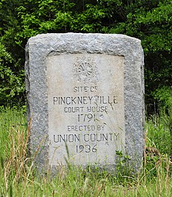
Pinckneyville (Union, South Carolina)
Pinckneyville | |
 Pinckneyville Monument, April 2012 | |
| Location | 13 miles northeast of Union on South Carolina Highway 13, near Union, South Carolina |
|---|---|
| Coordinates | 34°30′44″N 81°28′10″W / 34.51222°N 81.46944°W |
| Area | 1.8 acres (0.73 ha) |
| NRHP reference No. | 69000175[1] |
| Added to NRHP | December 3, 1969 |
Pinckneyville is a historic frontier settlement site located near Union, Union County, South Carolina. Pinckneyville was established on February 19, 1791, by the General Assembly of South Carolina Act #1491 along with the Washington district,[2] and is one of the earliest settlements in the South Carolina backcountry. Pinckneyville was named for Charles Cotesworth Pinckney.[2][3] Pinckneyville was chosen because it was central to Union County, but Union was the seat of power.[4]
The property includes the original site of Pinckneyville and contains the ruins of the brick structure mistakenly referred to as the jail[2] and one other brick building, usually referred to as the old store.[5][6]
Pinckneyville lasted until 1850.[3] By 1850 Pinckneyville was replaced by Union on the South Carolina census.[7] It was a combination of the railroad and population growth in the surrounding areas that killed it. Population in the sense that the surrounding areas got their own courts after the General Assembly restructured the court system in 1799.[4] And the railroad because it redirected traffic which starved out the town after the court left. Pinckneyville is currently in Union County and Union(back then Unionville) is the town the railroad went through. Previously stagecoach routes directed people to towns and stagecoach routes in the area traveled through the towns with the courts. The stagecoach then ran from Charleston, SC to Philadelphia, PA.[8] The Spartanburg and Union Railroad was planned in 1847 and finished in 1859 by then Union was the place businesses were moving to.
It was added to the National Register of Historic Places in 1969.[1]
References
[edit]- ^ a b "National Register Information System". National Register of Historic Places. National Park Service. July 9, 2010.
- ^ a b c Carrillo, Richard. "Archeological Excavations at Pinckneyville, Site of Pinckney District, 1791-1800". scholarcommons.sc.edu/. University of South Carolina. Retrieved August 17, 2016.
- ^ a b "Pinckneyville, South Carolina". www.carolana.com. Retrieved April 6, 2023.
- ^ a b Allen, Charles (1987). The Narrative History of Union County South Carolina (4th ed.). The Reprint Company.
- ^ Mrs. James W. Fant (November 1968). "Pinckneyville" (pdf). National Register of Historic Places - Nomination and Inventory. Retrieved July 1, 2014.
- ^ "Pinckneyville, Union County (S.C. Sec. Rd. 13, Pinckneyville)". National Register Properties in South Carolina. South Carolina Department of Archives and History. Retrieved July 1, 2014.
- ^ "1850 Census of Population: South Carolina" (PDF).
- ^ Vandergrift, Roy. "Roy Vandegrift Local Historian – Bringing History to Life".
Charleston, SC to Philadelphia, PA – a stage coach road c. 1775.
External links
[edit]


