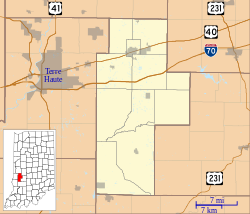
Purdy Hill, Indiana
Appearance
Purdy Hill | |
|---|---|
| Coordinates: 39°30′24″N 87°12′31″W / 39.50667°N 87.20861°W | |
| Country | United States |
| State | Indiana |
| County | Clay |
| Township | Posey |
| Elevation | 614 ft (187 m) |
| GNIS feature ID | 441666[1] |
Purdy Hill is an unincorporated community in Posey Township, Clay County, Indiana. It is part of the Terre Haute Metropolitan Statistical Area.
It was likely named for the Purdy family.[2]
Geography
Purdy Hill is located at 39°30′24″N 87°12′31″W / 39.50667°N 87.20861°W.
References
- ^ "Purdy Hill, Indiana". Geographic Names Information System. United States Geological Survey, United States Department of the Interior. Retrieved 2010-08-20.
- ^ Baker, Ronald L. (October 1995). From Needmore to Prosperity: Hoosier Place Names in Folklore and History. Indiana University Press. p. 273. ISBN 978-0-253-32866-3.
Purdy is a family name in Clay County...


