Qaqortoq
Qaqortoq | |
|---|---|
 Qaqortoq | |
| Federacy | Kingdom of Denmark |
| Country | |
| Municipality | Kujalleq |
| Founded | 1775 |
| Population (2010) | |
| • Total | 3,306 |
| Time zone | UTC-03 |
| Postal code | 3920 |
| Website | qaqortoq.gl |
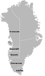
Qaqortoq (Danish: Julianehåb) is a town in the Kujalleq municipality in southern Greenland. With a population of 3,306 as of 2010,[1] it is the most populous town in southern Greenland, and the fourth-largest town in the country. The name is western Greenlandic and means "[the] white [one]".
History

The historical ruins of Hvalsey−the most prominent Norse ruins in Greenland−are located 19 km northeast of Qaqortoq. The town was founded by Norwegian trader Anders Olsen in 1775.[2]
Fountain
The town is home to the oldest fountain in Greenland.[3] For a long time, it was the only fountain in the country, until another was built in Sisimiut. A tourist attraction, the fountain depicts whales spouting water out of their blowholes.[2]
Transport
Qaqortoq is a port of call for the Arctic Umiaq Line coastal ship.[4] Qaqortoq Heliport operates year-round, linking Qaqortoq with Narsarsuaq Airport, and indirectly with the rest of Greenland and Europe.
Population
With 3,306 inhabitants as of 2010, Qaqortoq is the largest town in the Kujalleq municipality.[5] The population increased over 5 percent relative to 1990 and 2000 levels. The town is the only settlement in southern Greenland exhibiting growth patterns over the last two decades,[5] with migrants from the smaller settlements reinforcing the trend.
Climate
| Climate data for Qaqortoq, Greenland (1961-1990) | |||||||||||||
|---|---|---|---|---|---|---|---|---|---|---|---|---|---|
| Month | Jan | Feb | Mar | Apr | May | Jun | Jul | Aug | Sep | Oct | Nov | Dec | Year |
| Mean daily maximum °C (°F) | −2.2 (28.0) |
−1.7 (28.9) |
−1.0 (30.2) |
2.8 (37.0) |
6.9 (44.4) |
9.2 (48.6) |
11.1 (52.0) |
11.0 (51.8) |
8.0 (46.4) |
3.9 (39.0) |
0.8 (33.4) |
−1.4 (29.5) |
4.0 (39.1) |
| Mean daily minimum °C (°F) | −9.2 (15.4) |
−8.8 (16.2) |
−8.4 (16.9) |
−4.4 (24.1) |
−0.4 (31.3) |
1.3 (34.3) |
3.3 (37.9) |
3.7 (38.7) |
1.9 (35.4) |
−1.7 (28.9) |
−5.0 (23.0) |
−7.8 (18.0) |
−3.0 (26.7) |
| Average precipitation mm (inches) | 57 (2.2) |
51 (2.0) |
57 (2.2) |
56 (2.2) |
56 (2.2) |
75 (3.0) |
97 (3.8) |
93 (3.7) |
92 (3.6) |
72 (2.8) |
78 (3.1) |
73 (2.9) |
857 (33.7) |
| Source: Danish Meteorological Institute[6] | |||||||||||||
References
- ^ Statistics Greenland, Greenland in Figures, 2010
- ^ a b O'Carroll, Etain (2005). Greenland and the Arctic. Lonely Planet. p. 115. ISBN 1-74059-095-3.
- ^ Greenland.com, The Official Tourism and Business Site of Greenland
- ^ AUL, Timetable 2009
- ^ a b c Statistics Greenland
- ^ Danish Meteorological Institute Template:Da icon


