
Riva del Garda
Riva del Garda | |
|---|---|
| Comune di Riva del Garda | |
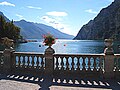
 Riva del Garda view with Lake Garda on the background | |
Location of Riva del Garda  | |
| Country | Italy |
| Region | Trentino-Alto Adige/Südtirol |
| Province | Trento (TN) |
| Frazioni | Campi, Pregasina, Rifugio Capanna Grassi, Rifugio Nino Pernici, San Nazzaro, Sant'Alessandro, Varone |
| Government | |
| • Mayor | Adalberto Mosaner |
| Area | |
| • Total | 42 km2 (16 sq mi) |
| Elevation | 70 m (230 ft) |
| Population (2004 official estimate)[2] | |
| • Total | 15,151 |
| • Density | 360/km2 (930/sq mi) |
| Demonym | Rivani |
| Time zone | UTC+1 (CET) |
| • Summer (DST) | UTC+2 (CEST) |
| Postal code | 38066 |
| Dialing code | 0464 |
| Patron saint | Absumption of Mary |
| Saint day | August 15 |
| Website | Official website |
Riva del Garda is a town and comune in the northern Italian province of Trento of the Trentino Alto Adige region. It is also known simply as Riva. The estimated population is 15,151.[3]
History
Riva del Garda belonged to the Republic of Venice, the Bishopric of Trent, the Napoleonic Kingdom of Italy and later (1815-1918) to the Austro-Hungarian empire. Since the end of World War I (November 3, 1918), Riva del Garda, with the rest of the Trentino, became part of the Kingdom of Italy.
Riva was the terminus for the 24 kilometres (15 miles) long Mori–Arco–Riva railway line, opened in 1891. However, the railway closed in 1936 and the railway terminus has been converted into a restaurant.
Geography
Riva del Garda is located at the north-western corner of Lake Garda, approximately 70 metres (230 feet) above sea level. The town is located at the southern edge of the Italian Alps, near the Dolomites. It is bordered by Monte Rocchetta to the west and Monte Brione, 376 metres (1,234 ft) above sea level, to the east. East of Riva del Garda is the village Torbole, bordered by Monte Baldo.
Climate
Winters are cold, sunny and with some snow; summers are warm but rarely hot, with windy afternoons and scattered thunderstorms at night.
Demographics
The 2001 census listed the population as 14,758. In 1991, it was recorded as 13,410. An official estimate in 2004 calculated the population as 15,151.[4] People from Riva are known as Rivani.
Economy
Tourism is the most important activity of the town. The town is also home to industries such as paper manufacturing.
Places of interest
The Museo Civico is located in the Rocca, a medieval fortress placed on the lake, bounded by a canal with lifting bridge. It is frequently the seat of cultural activities, especially during the summer months.
Places of geological interest in the vicinity include Tenno Lake, Lago di Ledro (with its paleoethnographic museum), and the Varone falls.
Sport
With its two harbours, Riva del Garda is well equipped for sailing and windsurfing. Rock climbing and mountain biking are also practiced. Basketball is also very popular and probably the main sport of the town: the local top team, the GS Riva Gardacartiere, plays in the Italy's 3rd national division and for the "big games" the PalaGarda arena is packed with up to 2,000 people. The town also has a team, Virtus Riva, in the "C1" division.
Photos
-
 Riva by night
 -
 Lake View
 -
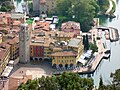 Piazza 3 Novembre
 -
 The Castle of Riva


Footnotes
- ^ "Superficie di Comuni Province e Regioni italiane al 9 ottobre 2011". Italian National Institute of Statistics. Retrieved 16 March 2019.
- ^ "Popolazione Residente al 1° Gennaio 2018". Italian National Institute of Statistics. Retrieved 16 March 2019.
- ^ Helders (2010)
- ^ Helders (2010)
Sources
- Helders, Stefan (2010), "Riva", Profile of geographical entity including name variants, Germany: World Gazetteer, archived from the original on 2013-02-10
External links
- Official site of Riva del Garda Tourist Board
- Information
- Riva Tourist Information
- Homepage of the city (Italian)
- Live weather station and webcams from Riva del Garda (English)
| Settlements |
|  |
|---|---|---|
| Islands |
| |
| Rivers | ||
| Wines | ||
| People | ||
