
Sasa, Israel
Sasa | |
|---|---|
 | |
 Sasa | |
| Coordinates: 33°1′36.83″N 35°23′40.2″E / 33.0268972°N 35.394500°E | |
| Country | Israel |
| District | Northern |
| Council | Upper Galilee |
| Affiliation | Kibbutz Movement |
| Founded | January 1949 |
| Founded by | Hashomer Hatzair members |
| Population (2022) | 396[1] |
| Website | www.sasa.org.il |
Sasa (Template:Lang-he-n) is a kibbutz in the Upper Galilee area of northern Israel. Located one mile from the border with Lebanon, it falls under the jurisdiction of Upper Galilee Regional Council. In 2022 it had a population of 396.[1]
History
The modern kibbutz was founded in January 1949 by a gar'in of North American Hashomer Hatzair members on the land of the depopulated Palestinian village of Sa'sa'.[2] Sa'sa' was demolished by the Israeli Seventh Brigade and Oded Brigade on October 30, 1948. Sa'sa' surrendered without resistance and allegations of Israeli atrocities later surfaced.[3] Many of the villagers from Sa'sa live in Nahr al-Bared, a Palestinian refugee camp in Lebanon,[4] although some resettled in nearby Jish.
On the grounds of the kibbutz is the alleged tomb of rabbi Levi ben Sisi, who is actually known to have died in far-away Babylonia during the first half of the third century.[5]
In 1992, the Palestinian historian Walid Khalidi described the remains of Sa'sa' village: "Some of the old olive trees remain, and a number of walls and houses still stand. Some of the houses are presently used by the kibbutz; one of them has an arched entrance and arched windows. A large portion of the surrounding land is forested, the rest is cultivated by Israeli farmers."[6] The village mosque has been converted into the kibbutz museum.
Economy
Sasa operates Plasan, a plastics factory that manufactures vehicle armour. The company, which is shared between some 100 families, is now a world leader in armor protection technology for vehicles. The kibbutz has signed contracts worth billions of dollars with major clients,[7]including the U.S. military.[8]
Other branches of the economy include a dairy, in cooperation with kibbutz Tuval; a beef herd; fruit trees (kiwi, apple, avocado and grapefruit); Bereshit, a fruit marketing company in cooperation with three other kibbutzim; and Sasa Tech, a manufacturer of technical and home care products.[9] Buza, a chain of ice cream shops founded by a Sasa resident, runs a branch on the kibbutz and offers ice cream workshops.[10]
Gallery
-
 Members of kibbutz Sasa in 1948
 -
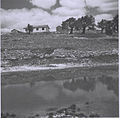 Kibbutz Sasa in 1949
 -
 U.S. Ambassador Dan Shapiro visiting Plasan, 2012


.jpg)
References
- ^ a b "Regional Statistics". Israel Central Bureau of Statistics. Retrieved 21 March 2024.
- ^ Khalidi, Walid (1992). All That Remains: The Palestinian Villages Occupied and Depopulated by Israel in 1948, Washington D.C.: Institute for Palestine Studies. p. 495
- ^ Operation Hiram
- ^ Ilan Pappé, "The Ethnic Cleansing of Palestine", page 183
- ^ Pictures of Tzaddikim's graves in Eretz Yisrael Yeshivat Tikun HaMidot
- ^ Khalidi, 1992, p. 497
- ^ Plasan Sasa wins contract
- ^ Kibbutz Sasa's Plasan nets second big U.S. military tender
- ^ Sasa website
- ^ the Sea of Galilee for the Galilee by the sea