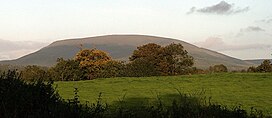
Silvermine Mountains
| Silvermine Mountains | |
|---|---|
| Irish: Sliabh an Airgid | |
 Keeper Hill | |
| Highest point | |
| Peak | Keeper Hill |
| Elevation | 694 m (2,277 ft) |
| Geography | |
| Country | Republic of Ireland |
| Provinces of Ireland | Munster |
The Silvermine Mountains (Irish: Sliabh an Airgid[1]) are a mountain range situated in County Tipperary (the foothills run into County Limerick) in Ireland. The highest peak of the range is Slieve Ciamalta or Keeper Hill at 694m (2,277ft) high.
There are three Special Areas of Conservation in the Silvermine Mountains, Silvermine Mountains,[2] Silvermine Mountains West[3] and Keeper Hill.[4]
The range is often referred to as the Silvermines Mountains or simply The Silvermines (both using Silvermines plural) however the recognized name is Silvermine (singular) Mountains[5]
The village of Silvermines is located to the north of Keeper Hill and has been a mining centre since the 14th century.
Slieve Felim Way
The Slieve Felim Way, a 43 kilometres (27 miles) long-distance trail through the Silvermine and Slieve Felim Mountains has a trail-head in the village of Silvermines. It is designated as a National Waymarked Trail by the National Trails Office of the Irish Sports Council and is managed by Shannon Development and Coillte.[6]
References
52°47′N 8°15′W / 52.783°N 8.250°W
- ^ http://www.logainm.ie/67262.aspx
- ^ http://www.npws.ie/protectedsites/specialareasofconservationsac/silverminemountainssac/
- ^ http://www.npws.ie/protectedsites/specialareasofconservationsac/silverminesmountainswestsac/
- ^ http://www.npws.ie/protectedsites/specialareasofconservationsac/keeperhillsac/
- ^ http://www.logainm.ie
- ^ National Trails Office 2010, p. 43.

