
Skrapar District
This article needs additional citations for verification. (December 2009) |
Skrapar District | |
|---|---|
 Map showing Skrapar District within Albania | |
| Country | |
| Capital | Corovode |
Skrapar District (Albanian: Rrethi i Skraparit) was one of the thirty-six districts of Albania (which were dissolved in 2000) that is now part of Berat County. It had a population of 10,200[2] (2010 estimate), and an area of 775 km². It is in the centre of the country, and its capital is Çorovodë. It is most famous for Skrapar Raki, a traditional brandy consumed by many Albanians.
Administrative divisions
The district consisted of the following municipalities:
Skrapar Municipality
Poliçan Municipality
Note: - urban municipalities in bold
Notable people
- Abas Ermenji, Albanian politician and historian
- Riza Cerova, Albanian political figure
- Xhelal bej Koprencka, modern Albania's founding father
- Ilir Meta, Albanian politician
Gallery
-
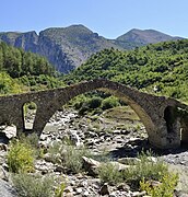 Kasabashi Bridge near Çorovodë
 -
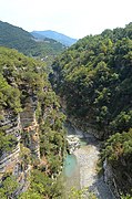 Osum Canyon
 -
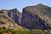 Gradec Cliffs near Çorovodë


References
- ^ "POPULLSIA SIPAS PREFEKTURAVE, 2001–2010". Albanian Institute of Statistics. Archived from the original on 2011-07-24. Retrieved 2010-09-09.
{{cite web}}: Unknown parameter|deadurl=ignored (|url-status=suggested) (help) - ^ "POPULLSIA SIPAS RRETHEVE, 2001-2010". Albanian Institute of Statistics. Archived from the original on 2012-03-10. Retrieved 2010-09-09.
{{cite web}}: Unknown parameter|deadurl=ignored (|url-status=suggested) (help)
External links
Districts in Albania were geographic divisions made up of cities, towns and villages. They were abolished in 2000. | |
| (36) | |
40°33′N 20°15′E / 40.550°N 20.250°E
This article about a specific location in Berat County, Albania, is a stub. You can help Wikipedia by expanding it. |