
Tanjung Sepat, Pahang
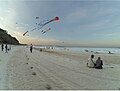
Tanjung Sepat or better known as Pantai Sepat is a typical Malay fishing village located about 10 km from Kuantan and is located on the way south to the royal town of Pekan. From Kuantan, it is accessible via Jalan Abu Bakar ![]() FT 183 and is an alternative way to the royal town of Pekan. Unlike beaches which slope to the sea for a few meters and then suddenly drop deep, the beach at Pantai Sepat seems to slope very gradually to the sea. The beach is famous among locals as the place is serene and tranquil.
FT 183 and is an alternative way to the royal town of Pekan. Unlike beaches which slope to the sea for a few meters and then suddenly drop deep, the beach at Pantai Sepat seems to slope very gradually to the sea. The beach is famous among locals as the place is serene and tranquil.
Gallery
-
 Tanjung Pantai Sepat Beach, Kuantan, Pahang

3°41′24″N 103°20′20″E / 3.69000°N 103.33889°E
| Topics |
|
|---|---|
| Society | |
| Administrative divisions | |
This Pahang location article is a stub. You can help Wikipedia by expanding it. |