
Thakurgaon Sadar Upazila
Thakurgaon Sadar
ঠাকুরগাঁও সদর | |
|---|---|
| Country | |
| Division | Rangpur Division |
| District | Thakurgaon District |
| Area | |
| • Total | 683.45 km2 (263.88 sq mi) |
| Population (2011) | |
| • Total | 581,227[1] |
| Time zone | UTC+6 (BST) |
| Postal code | 5100 |
| Website | Official Thakurgaon website |
Thakurgaon Sadar (Bengali: ঠাকুরগাঁও সদর) is an Upazila of Thakurgaon District in the Division of Rangpur, Bangladesh.[2]
Geography
Thakurgaon Sadar is located at 26°01′15″N 88°28′00″E / 26.0208°N 88.4667°E . It has 79823 households and total area 683.45 km².
Demographics
As of the 1991 Bangladesh census, Thakurgaon Sadar has a population of 422728. Males constitute 51.7% of the population, and females 48.3%. This Upazila's eighteen up population is 214112. Thakurgaon Sadar has an average literacy rate of 30.1% (7+ years), and the national average of 32.4% literate.[3]
Administration
Thakurgaon Sadar has 22 Unions/Wards, 215 Mauzas/Mahallas, and 198 villages.
Gallery
-
 The Monument of 1971 War beside Tangon River
 -
 Shuk River at Thakurgaon Sadar Upazila
 -
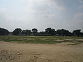 Playground of Thakurgaon
 -
 Tangon River from Tangon Bridge
 -
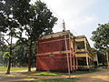 A science building of Thakurgaon Govt.College.


See also
References
- ^ "Thakurgaon (District (Zila), Bangladesh) - Population Statistics and Location in Maps and Charts". citypopulation.de.
- ^ Abu Md. Iqbal Rumi Shah (2012), "Thakurgaon Sadar Upazila", in Sirajul Islam and Ahmed A. Jamal (ed.), Banglapedia: National Encyclopedia of Bangladesh (Second ed.), Asiatic Society of Bangladesh
- ^ "Population Census Wing, BBS". Archived from the original on 2005-03-27. Retrieved November 10, 2006.
| Upazila/Thana: | ||
|---|---|---|
Capital: Rangpur | ||
| Dinajpur District |  | |
| Gaibandha District | ||
| Kurigram District | ||
| Lalmonirhat District | ||
| Nilphamari District | ||
| Panchagarh District | ||
| Rangpur District | ||
| Thakurgaon District | ||
This Rangpur Division location article is a stub. You can help Wikipedia by expanding it. |