
Trèbes
You can help expand this article with text translated from the corresponding article in French. (December 2008) Click [show] for important translation instructions.
|
Trèbes | |
|---|---|
 | |
.svg) Coat of arms | |
Location of Trèbes  | |
| Country | France |
| Region | Occitania |
| Department | Aude |
| Arrondissement | Carcassonne |
| Canton | Capendu |
| Intercommunality | Carcassonnais |
| Government | |
| • Mayor (2008–2014) | Claude Banis (DVD) |
| Area 1 | 16.36 km2 (6.32 sq mi) |
| Population (2008) | 5,524 |
| • Density | 340/km2 (870/sq mi) |
| Time zone | UTC+01:00 (CET) |
| • Summer (DST) | UTC+02:00 (CEST) |
| INSEE/Postal code | 11397 /11800 |
| Elevation | 67–161 m (220–528 ft) |
| 1 French Land Register data, which excludes lakes, ponds, glaciers > 1 km2 (0.386 sq mi or 247 acres) and river estuaries. | |
Trèbes is a commune in the Aude department in southern France.
Population
| Year | Pop. | ±% |
|---|---|---|
| 1793 | 1,087 | — |
| 1800 | 1,087 | +0.0% |
| 1806 | 1,206 | +10.9% |
| 1821 | 1,387 | +15.0% |
| 1831 | 1,607 | +15.9% |
| 1836 | 1,707 | +6.2% |
| 1841 | 1,773 | +3.9% |
| 1846 | 1,901 | +7.2% |
| 1851 | 1,871 | −1.6% |
| 1856 | 1,888 | +0.9% |
| 1861 | 1,714 | −9.2% |
| 1866 | 1,764 | +2.9% |
| 1872 | 1,765 | +0.1% |
| 1876 | 2,001 | +13.4% |
| 1881 | 2,171 | +8.5% |
| 1886 | 2,209 | +1.8% |
| 1891 | 1,858 | −15.9% |
| 1896 | 1,804 | −2.9% |
| 1901 | 1,840 | +2.0% |
| 1906 | 2,006 | +9.0% |
| 1911 | 1,962 | −2.2% |
| 1921 | 2,000 | +1.9% |
| 1926 | 1,992 | −0.4% |
| 1931 | 2,021 | +1.5% |
| 1936 | 2,068 | +2.3% |
| 1946 | 2,057 | −0.5% |
| 1954 | 2,179 | +5.9% |
| 1962 | 2,294 | +5.3% |
| 1968 | 2,958 | +28.9% |
| 1975 | 4,007 | +35.5% |
| 1982 | 5,526 | +37.9% |
| 1990 | 5,575 | +0.9% |
| 1999 | 5,495 | −1.4% |
| 2008 | 5,524 | +0.5% |
Monument
-
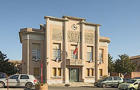 Town hall
 -
 Canal du Midi in Trèbes
 -
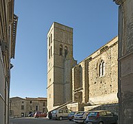
 Church Saint-Étienne
 -


See also
References
External links
Wikimedia Commons has media related to Trèbes.
This Aude geographical article is a stub. You can help Wikipedia by expanding it. |