User:Jokulhlaup/Mew
 | |
 | |
| Location | Tory Island, County Donegal, Ireland |
|---|---|
| Coordinates | 55°16′22″N 8°14′56″W / 55.272711°N 8.249016°W |
| Tower | |
| Constructed | 1832 |
| Automated | 1990 |
| Height | 27 metres (89 ft) |
| Operator | Commissioners of Irish Lights |
| Fog signal | discontinued in 1994 |
| Racon | Morse M |
| Light | |
| First lit | 1832 |
| Focal height | 40 metres (130 ft) |
| Lens | hyperradiant Fresnel lens |
| Range | 18 nautical miles (33 km; 21 mi) |
| Characteristic | Fl(4) W 30s. |
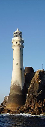
Tory Island Lighthouse is an active aid to navigation located on Tory Island off the coast of County Donegal, Ireland. It acts as a one of the major landfall lighthouse for the northern coast of Ireland, and was completed in 1832. The lighting system underwent substantial modifications in 1887, with the installation of a rotating hyperradiant Fresnel lens the largest type made for a lighthouse. The original 1887 optic was removed and re-engineered in the 1920s by dividing it into two, creating a smaller bi-form optic that is still in situ and in use. The second optic created was installed at Mew Island Lighthouse. A number of different fuels have been used as a light source, it now uses an LED system within the hyperradiant optic. Operated by the Commissioners of Irish Lights it was automated in 1990.
History[edit]
The need for a new lighthouse on Tory Island was raised by the ship owners and Harbour Commissioners of Sligo, a port to the south. The request was endorsed by the Dublin Ballast Board, the predecessor of the Commissioners of Irish Lights, and approved by Trinity House at the end of 1828.[1]
Work on the light station was undertaken by men from the Ballast Board, to a design by George Halpin who was the Inspector of lighthouses. Completed in 1832, the cost of the works was £16,563 (equivalent to £1,637,145 as of 2021)[2][3] and included a tower, keeper's houses and ancillary buildings.[4][1]
The substantial 27-metre-high (89 ft) tower was built using locally sourced granite, with "walls [that] are 7 feet thick at the first floor, gradually tapering upwards to a thickness of about 3 feet 6 inches under the gallery".[4] It was first lit in August 1832, and had a fixed light using oil burning lamps, with reflectors and was visible for 17 miles. (Reids 1843) In 1862 this was changed to a "six-wick first-class dioptric fixed oil-light ... The dioptric apparatus consisted of a bee-hive shaped lens".[4]
1887 modifications[edit]
In 1887 William Douglass designed and supervised works at the lighthouse, so that a much larger rotating hyperradiant lens system could be installed within a new lantern room, using gas burners as an illuminant.[4] The hyperradiant optic was the largest type ever used for lighthouses having a focal length or radius of 1,330 mm (52 in). It consisted of three tiers of lenses stacked above each other, with each tier having six panels, spanning 60 degrees.[5]
This tri-form optic, had three tiers of lenses each with its own set of 108 gas burners. The output from the light could be varied according to the number of jets used. On a clear night just 32 were lit in the lower tier, but in poor conditions such as fog, all three tiers could be lit using 324 burners.[4]
The gas used in the light and the fog siren engines was generated by burning cannel coal in a gas plant alongside the tower, and was stored in gasometers prior to being used.[4]
1920s
In the 1920s, it was removed from Tory Island, and re-engineered by Chance Brothers in Smethwick, where it was reduced in size to a bi-form system with only two tiers. Two of the six bullseye panels were replaced by metal blanks, producing a light characteristic of four flashes of white light every thirty seconds. To enable the optic to turn freely it was mounted upon a circular bath of mercury known as a mercury float, providing an almost frictionless bearing.[6] The redesigned light was then installed at Mew Island in 1928. It was lit using paraffin, making the coal plant redundant, .[5][1] In 1972 generators were installed at the lighthouse, allowing the use of electric light to replace the paraffin burners, and an electric motor to replace the weight driven rotation system.[7]
Operations[edit]
The lighthouse has an automatic identification system transmitter, and a radar beacon emitting the letter M as a Morse character(— — ).[1] It is registered under the international Admiralty number A6200 and it has the NGA identifier of 114–7280.[8]
See also[edit]
References[edit]
- ^ a b c d "Tory Island Lighthouse". Commissioners of Irish Lights. Retrieved 24 August 2020.
- ^ UK Retail Price Index inflation figures are based on data from Clark, Gregory (2017). "The Annual RPI and Average Earnings for Britain, 1209 to Present (New Series)". MeasuringWorth. Retrieved 11 June 2022.
- ^ "Co. Donegal, Tory Island, Lighthouse". Dictionary of Irish Architects. Department of Arts, Heritage and the Gaeltacht. Retrieved 24 August 2020.
- ^ a b c d e f Salmond, David (1892). "The Illumination By Gas Of Tory Island Lighthouse, County Donegal. (Includes Plate)". Minutes of the Proceedings of the Institution of Civil Engineers. 108 (1892): 221–228. doi:10.1680/imotp.1892.20194. Retrieved 14 August 2020.
- ^ a b Cite error: The named reference
uslhswas invoked but never defined (see the help page). - ^ Cite error: The named reference
glmatwas invoked but never defined (see the help page). - ^ "The Great Light 3. Changes Over Time" (PDF). Titanic Foundation Limited. Retrieved 24 August 2020.
- ^ Rowlett, Russ. "Lighthouses of Western Ireland (Ulster and Connacht)". The Lighthouse Directory. University of North Carolina at Chapel Hill. Retrieved 24 August 2020.

