Maps of Lochaber
Hi Folks!! I'm looking to find some kind of map of the Rhu Peninsula. It is a small peninsula and completely ignored so far. It has centuries of history for such a small place. The location can be found from the article. I tried to get a map from OpenStreetMap but couldn't. Anyhelp is appreciated. Thanks. scope_creepTalk 17:22, 11 August 2021 (UTC)
@Scope creep: Hi, "some kind of map" is a bit wide. What kind of map, there are so many different types so it's more up to what you want and need. Can you link to a map of the type you want, also please show which area you want. We can go from there but I will need your help and knowledge to be able to create what you want. --always ping me-- Goran tek-en (talk) 17:44, 26 September 2021 (UTC)
@Goran tek-en: How goes? It good to see your still about. I will do. I need to take a look at it and some represents. I will be back. scope_creepTalk 18:20, 26 September 2021 (UTC)
@Goran tek-en: I think probably some kind of location map, that shows that corner of Scotland, with the pensinsula, e.g. on the Applecross. There may be one available for that corner. I'll check. I found this Ardnamurchan, the satellite map, looks quite cool. I'll put the location map on, found one, and see how it looks. scope_creepTalk 10:56, 28 September 2021 (UTC)
@Goran tek-en: The location map point obliterates the location as its so small. I came across this image on Ardnamurchan. It is a satellite. Its shows it in more detail. Something along those lines, possibly. One image that is a good size, that shows it in details. For example, Gower Peninsula. This article has an old map and new map, at the bottom, that looks ideal. It shows the outline, how it is connected to the mainland and some details of the surface, [1]. That type is ideal. It seems to be an Ordnance Survey map. I'm not sure how to get hold of them. scope_creepTalk 11:13, 28 September 2021 (UTC)
@Scope creep:, thanks for info. I will start and then we will decide more as we go along. Will be back.
Request taken by --always ping me-- Goran tek-en (talk) 15:37, 28 September 2021 (UTC).
@Goran tek-en: A bit more to the right, where it joines the main coast. Top, left and bottom are ok. scope_creepTalk 17:18, 28 September 2021 (UTC)
@Goran tek-en: It finished somewhere around the Latitude/Longitude: 56° 53′ 37″ N 5° 46′ 20″ W. I can't remember exactly, its been several months since I looked at the article. scope_creepTalk 17:25, 28 September 2021 (UTC)
scope_creep Those drafts are PNG versions of the original SVG file I'm working in and will upload to commons.
For the ones called "map" there should be another color of the land which is "outside of main interest" eg main land. But I don't know where to draw it. So if you want it you have to tell me/show me.
I can remove/add any of what's in those drafts. If you want names there you will have to write them here and tell me where to put them.
@Goran tek-en: Great maps. I mean--great. There is a location map on the article already, so the location maps on right are not needed. Is it possible to use both of them. I can stack them in a multiple image template. Two secs. The main infobox on each of them. It says Motor Way it the A830 road. The secondary routes around Arisaig is the B8008. The roads that in the pensinsula is a track. I think. I've not been there. I can't take a look at it on Google Earth. It is a road. When it comes out of Arisaig, it changes from a B road just road with no name. Is it possible to names to them? I'll do names, but it will take me a bit to it. Back soon. scope_creepTalk 21:10, 1 October 2021 (UTC)
scope_creep We can make as many different versions you need. You should think of that whatever is created here at commons is just not for your article, it's available for anyone in any circumstance. So if you don't want the location maps to the right I will upload versions with them as someone else might need them, to me it's difficult to understand a map like this without them.
I wont change anything in the legends or add names right now, I will wait for you to came back with the complete info.The definitions for roads I used is from OSM so it might not be correct. Tell me which road should be which level and I will change names and type of line. --always ping me-- Goran tek-en (talk) 13:06, 2 October 2021 (UTC)
@Goran tek-en: I couldn't do anything at the weekend. The family were up. I've made a start. scope_creepTalk 23:33, 4 October 2021 (UTC)
56.901746, -5.856653 Camas an T-Salainn
56.900107, -5.865492 Port a Mhuilim
56.901902, -5.872618 Sgeirean Buidhe
56.903428, -5.901536 South Channel
56.909281, -5.883173 Loch nan Ceall
56.891859, -5.934538 Rubh’ Arisaig
56.881787, -5.931534 Eilean Port nam Murrach
56.874841, -5.914583 Port a' Bhàthaich
56.871773, -5.899019 Eilean a' Ghaill
56.870272, -5.890094 Camas Drollaman
56.881785, -5.865980 Camas Leathann
56.881785, -5.865980 Car an Daimh
56.882207, -5.835516 Camas Ghaoideil
56.902563, -5.893229  Tòrr Mòr
56.890686, -5.907655 Neolithic carved stone
56.892995, -5.828741 Cup marked stone
These two constitute the point and the hill.
56.886460, -5.894208, Cruach Doire an Dòbhrain
56.886366, -5.894380 hill point. This is just a dot.
56.885856, -5.846306 Doire Fhada (show almost vertically a slight inclination to the right)
56.895148, -5.875359 Loch a' Mhuilinn
56.887557, -5.878363 Loch Doire Ghioghain
56.883666, -5.883942 Coire Camas Drollaman
56.889665, -5.862570 Loch Torr a' Bheithe
56.889665, -5.862570 Loch Dubh
56.896320, -5.846963 Druim an Dubh-leathaid
56.888207, -5.914734  Rhue Cott.
56.903456, -5.901170South channel
56.898518, -5.891041 Rhumach
56.897768, -5.873532 Millburn Cott
See how that looks. scope_creepTalk 22:09, 6 October 2021 (UTC)
scope_creep I don't understand. I have checked 3 of the "Places" but they gives me locations in the see. The ones under "These two constitute the point and the hill" is locations on land but for what.
Before you talked about the roads having wrong labels and types of lines. Where you not to tell me which should be what?
I don't understand what you want me to do with the "Places" and "These two constitute the point and the hill". --always ping me-- Goran tek-en (talk) 16:22, 7 October 2021 (UTC)
@Goran tek-en: I was hoping you can put these text labels on the map. The Cruach Doire an Dòbhrain is a text label and point coordinate, is just that a point that constitutes the hill, i.e. the top of it. Yip, several are the bays and features around the article. They are the names of the places. I took them from here [2] at 56.891940, -5.862561, that shows the labels in place. I was planning to put in Neolithic, but there is too many, about 70 odd points and it would have been too much work. I have put in two neolithics labels, one at the cup stone and one at Neolithic carved stone. scope_creepTalk 16:36, 7 October 2021 (UTC)
@Goran tek-en: .The ones in the sea need to be much bigger. The ones in the coast should follow the contours of the map and be closer to them. I've uploaded this map to Google Drive. [3]. It is the ordanance survey map of the area, that gives you the idea of what the labels look like. Its really bigger in the right places, and orientated to the right direction. I don't think it need to be done in the green maps that show forests etc, unless you have started it. It's a goodly amount of work. Or it might take seconds, I don't know. I like the wee green triangles. Better than the original and cool. Font size is good, except in needs to be bigger in the sea. Hope that makes sense. Eilean means island. scope_creepTalk 17:46, 8 October 2021 (UTC)
scope_creep Sorry but no, it doesn't make sense. I can't read your mind or see the image you have in your mind of what you want.
1. You have given me extremely exact locations for "Places" and so far (of the ones I did) none has been close to the coast. Now it seems that you are rather talking about areas of the seas, not a specific location. Is it areas (I would need information for each) or what?
2. In the map you linked to, some names are blue and some are black. What does each color mean?
Blue means water. Black mean land. scope_creepTalk 21:11, 8 October 2021 (UTC)
I'm not to keen of putting names like in that map, the blue ones (bent, rotated), as it to me makes the map so much harder to interpret. So if it's areas I will have to fix it some other way.
That is how it is show on the map. They are quite to read. If they are horizantal, can you put them as close to the source point as possible. I intend to link the bays, for example to article sources at some point.
3. I would need a direct link for that map or from which book, page etc you got it so I can put it up for information source.
Canmore, Ordanance Survey
4. What do you mean by "I like the wee green triangles", I haven't put in any green triangles? --always ping me
They wee green triangles at the bottom of each text label. -- Goran tek-en (talk) 19:44, 8 October 2021 (UTC)
scope_creep If you look at your first Place, 56.901746, -5.856653 Camas an T-Salainn. Search Google maps for those coordinates, look at your map source for the name. I see it as the canmore map shows an area which is much further in to the bay than what those coordinates gives. It doesn't make sense to me.
To transfer the placing of the coordinates to our map is also difficult so I have to go by what I see. I will do some and get back to you. --always ping me-- Goran tek-en (talk) 16:00, 9 October 2021 (UTC)
scope_creep Check where the coordinates takes you for those two, 56.891859, -5.934538 Rubh’ Arisaig and 56.881787, -5.931534 Eilean Port nam Murrach, they are really of. As many coordinates are of I have removed them for the areas in bays etc. I have made everything in "Places" so check before I continue. I have changed the roads also.
The place triangels are actually a red color. --always ping me-- Goran tek-en (talk) 18:15, 9 October 2021 (UTC)
Drive by comment: The main paved road on the peninsula is difficult to make out without greatly enlarging the map. Possibly it could be coloured? Gog the Mild (talk) 18:19, 9 October 2021 (UTC)
@Goran tek-en: Those maps are really really decent.
elevation with forest-3. I think it is much better. Map 1 as well.
Roads. Can you make the major route the A830 and the minor B8008. The rest are ok.
The names are on it. Brain is dead. I need to add Arisaig and one other village and a loch name in south-east. I notice the hill names are not there. places, got you.
The coordinates you gave look as though they are out on the sea. I see now. It is the zoom level.
Try 56.891859, -5.934538 -> 56.892093, -5.930000
The one at 56.881787, -5.931534, is long due to its name. If you can place them as close as you need to, to the places, e.g. an bay, or an island. I have monitor set to giant font, so I can see it properly. That can only be the reason.
Can you please add 56.879501, -5.791591 Loch Nam Uamh
56.910407, -5.839299 Arisaig
Apart from that. Map 1 and 2. The deep forest wee icons are visually attractive and better than the base green.
Change Secondary Route into B8008 in the Index box. They are what the roads are called. The A830 is the red road with a dashed line and the simple red line around Arisaig is the B8008.
To fill in the tops and bottom bits at the right please add:
Saideal ha Ceapaich at 56.908489, -5.857578
Missed the island : Luinga Mhor at 56.900244, -5.933796
Camas na h-Eilde 56.891903, -5.770374
Thats every. That fills in the corner, the top and island.
21:56, 12 October 2021 (UTC)
scope_creep If you don't sign your post it seems as the ping doesn't work.
Isn't Camas na h-Eilde to far to the east for this map?
@Goran tek-en: Yip. Those maps are now perfect. I think that is them finished. scope_creepTalk 17:13, 14 October 2021 (UTC)
scope_creep I will need the following for each of the files;
Name of the file
Description (/language)
Captions/s (/language)
Category/ies at commons
to be able to upload it at commons. If you don'y know about Captions read here. --always ping me-- Goran tek-en (talk) 18:13, 14 October 2021 (UTC)
@Goran tek-en: How about
Name of the file:
Map 1 is Rhu Peninsula map 1
Map 2 is Rhu Peninsula elevated thematic map 1"
Description (/language)
Map 1 is Rhu Peninsula map with neolithic features
Map 2 is Rhu Peninsula elevation map with neolithic features
Captions/s (/language)
Map 1 is Rhu Peninsula map that contains names of features
Map 2 is Rhu Peninsula thematic map containing names of features
scope_creep I can't find those two categories at commons; Maps of Rhu Peninsula, Maps of Lochaber. --always ping me-- Goran tek-en (talk) 13:05, 15 October 2021 (UTC)
Thanks @Goran tek-en:. They are beautiful maps. If your up for it, in a couple months I would like to do another map for another peninsula. There is nothing on that page. Excellent work. {{resolved}}
scope_creep Thanks, just ping me and we will see. And I get knowledge of places I can visit I never knew about. --always ping me-- Goran tek-en (talk) 16:59, 15 October 2021 (UTC)
Battle of Oroscopa is at FAC and it has been suggested that the information on the second map - File:Carthage location 2.png - which is just the position of Carthage, could be transferred to a version of the first map - File:Map of kingdom of numidia ancient algeria (cropped).png - and the location of Rome added. In an ideal world the map would also be tidied up a little to look more professional and in a perfect world, shading added to show territory controlled by Carthage and Rome. Thanks. Gog the Mild (talk) 13:57, 5 October 2021 (UTC)
Discussion
@Gog the Mild: I can help you but I will need your help and knowledge in the process, will you be here? --always ping me-- Goran tek-en (talk) 15:40, 21 October 2021 (UTC)
Great. Thanks Goran tek-en. Yep, I pretty much live on Wikipedia, bar the odd day out. So hopefully I can respond to queries fairly quickly - most of the time. Gog the Mild (talk) 15:43, 21 October 2021 (UTC)
Request taken by --always ping me-- Goran tek-en (talk) 17:01, 21 October 2021 (UTC).
I would need maps or similar information of the different territories to add and anything else you would want in this map. --always ping me-- Goran tek-en (talk) 17:01, 21 October 2021 (UTC)
Goran tek-en, the Carthaginian territory is the NE part of N Africa, roughly modern Tunisia, not controlled by Numidia. (Usually Carthaginian territory is shown in grey, as in this map File:First Punic War 264 BC v3.png, but that is not vital.) This gif - File:Roman Empire map-2.gif - at 150 BC gives a passably accurate idea of the extent of the Roman Republic at the time. (Which is usually shown in red.) Does that help/is that sufficient? Gog the Mild (talk) 17:23, 21 October 2021 (UTC)
@Gog the Mild: As always the different maps don't match each other in perspective and proportions so I had to guess a bit. Check so the areas are correct, especially around lakes etc. Do you want same symbol for the cities or what?
This draft is a PNG version of the original SVG file I'm working in and will upload to commons. Draft-1. --always ping me-- Goran tek-en (talk) 14:05, 22 October 2021 (UTC)
It looks good, and the symbols for cities work for me. However, I seem to have miscommunicated a little. Apologies.
Roman territory is fine.
What is currently labelled as Carthaginian territory is actually Numidian territory. In an ideal world it should be some colour other than grey.
Carthaginian territory is all of the the NE part of N Africa, roughly modern Tunisia, not controlled by Numidia. This is currently in default yellow, but it would be nice if it could be in grey.
@Gog the Mild: So you want three areas? And for the overlap between Numidian and Carthaginian territory, which part has that area? --always ping me-- Goran tek-en (talk) 16:10, 22 October 2021 (UTC)
If possible, yes please - three areas. I am not really understanding the "overlap" query. There is no overlap. Possibly you could rephrase the question?
Goran tek-en, the yellowish area belonged to Numidia. The grey area immediately below is/was desert and did not belong to anyone. Gog the Mild (talk) 18:50, 22 October 2021 (UTC)
Many thanks Goran tek-en, that is quality work, and quicker than I had anticipated. Now in two FAs and a GA. Gog the Mild (talk) 20:47, 24 October 2021 (UTC)
Gog the Mild Thanks for that, I don't know what you mean by "FAs and a GA", I just do graphic work. --always ping me-- Goran tek-en (talk) 12:44, 25 October 2021 (UTC)
@Goran tek-en:Featured articles are "considered to be some of the best articles Wikipedia has to offer". There are currently 6,022 on the English Wikipedia, or about 0.09% of its 6,399,896 articles. "A good article is an article that meets a core set of editorial standards ... passing through the good article nomination process successfully." There are currently 35,253, or about 1 in 182. Gog the Mild (talk) 13:03, 25 October 2021 (UTC)
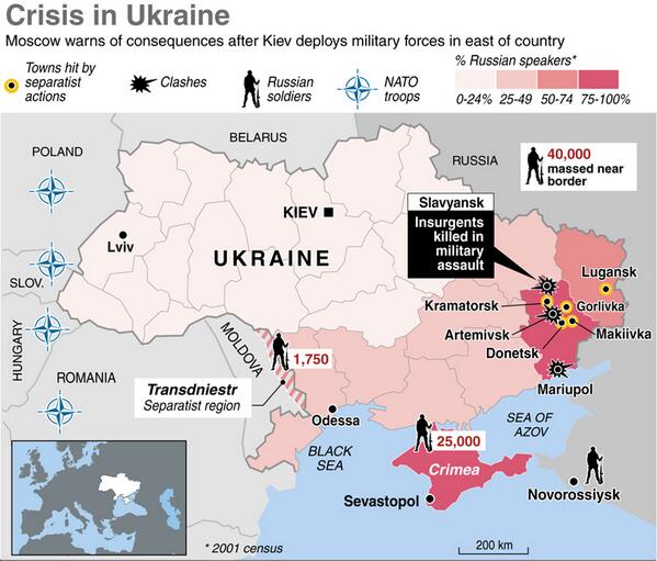
Request: Hi can anyone rise to the challenge of making a map for the Russo-Ukrainian conflict. We have many maps of territorial changes in the east over the month-years, but nothing detailed in English that gives an overview of the operation in Crimea and the situation in East. I have compiled some map resources that might be of use in making those maps.
Maps of Crimea: We could use an English map with some level of detail regarding the Feb-March 2014 invasion,
Thanks. --Jakey222 (talk) 14:52, 10 October 2021 (UTC)
Discussion
Request taken by --always ping me-- Goran tek-en (talk) 16:52, 10 October 2021 (UTC).
Extended content
@Jakey222: Thanks for putting in information so we have something to work from.
I will take this but I will need your help and knowledge all the way.
To start with we have to decide which area the map should cover, would it be Krim with some space around or should it be a larger area? Bigger area means harder to depict details. I'm not sure if you mean the whole conflict or specifically Krim.
Are elevations important for the map?
I will start on a base map depending on your answers to above, thanks. --always ping me-- Goran tek-en (talk) 16:52, 10 October 2021 (UTC)
I am hopping for two maps, one for each of the main regions/sections: #Crimea and #Donbas.
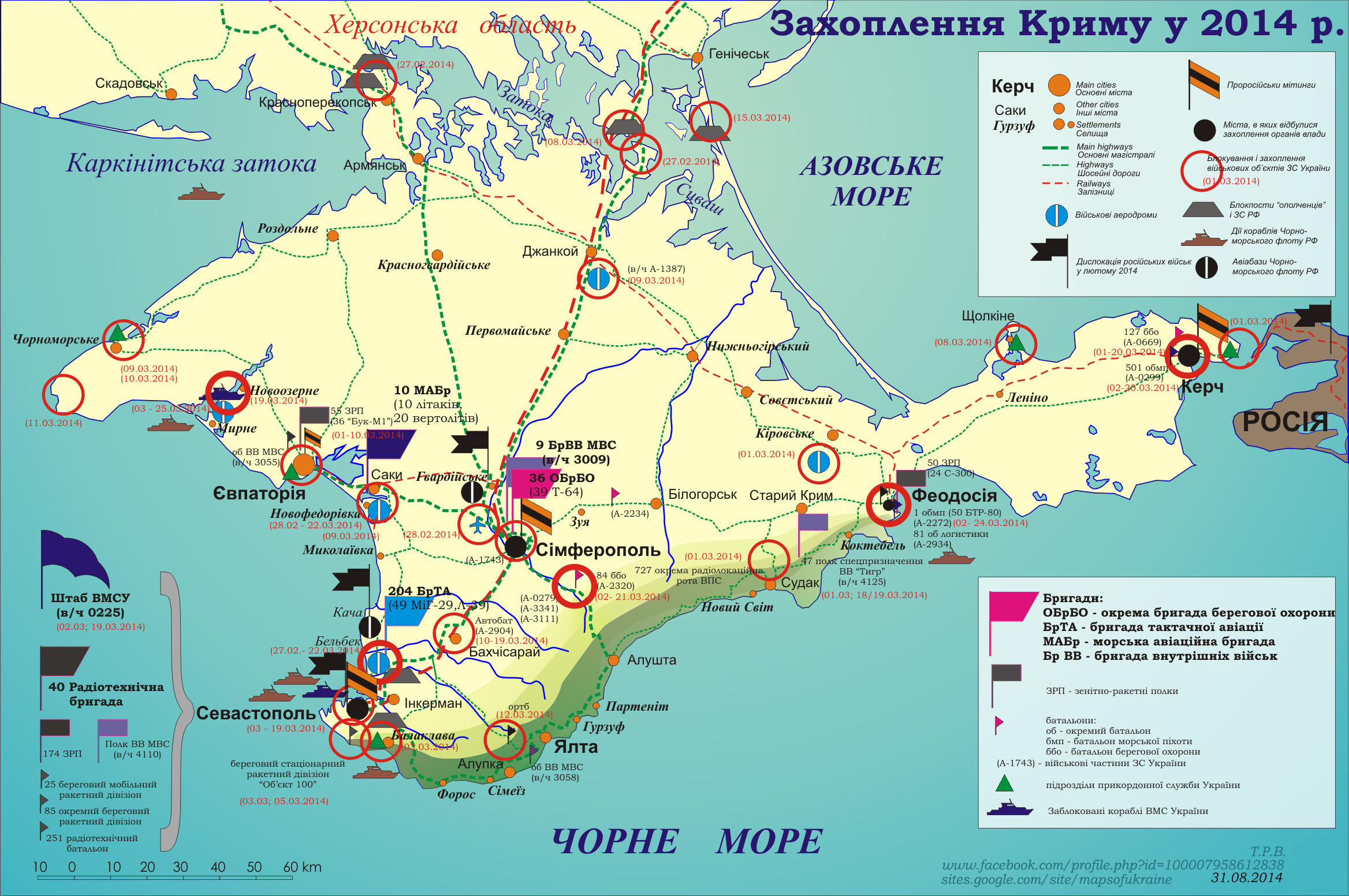
In Crimea, Russia capitalized the uncertainty and was able to takeover fast without resistance. I think here a "battle-map", low level overview, that focus only on Crimea would be best. In similar fashion to the current non-English map, with as much detail you can put in without getting it cluttered. --Jakey222 (talk) 18:37, 10 October 2021 (UTC)
In East Ukraine, we already have maps for specific battles and changes in territorial possessions in Donbas region. What we lack is higher level overview of the situation on the eve of conflict that shows all of Ukraine borders. In July, when armed conflict broke in Donbas, Russia wasn't yet engaged conventionally, however, its troop build up on Ukraine border ~2,000km is important part of understanding the dynamic the Russia-Ukraine conflict.
I linked to this thread on the article talk page, hopefully other interested parties (like @Mzajac:) will have further input. --Jakey222 (talk) 18:37, 10 October 2021 (UTC)
@Jakey222: I'm a graphic worker and I have zero knowledge (or almost) on this subject, I don't make research or read a lot of text. What I need is detailed explanations or preferable images showing me which areas you are looking for.
I made this map before Minsk Protocol II, is that the area for Donbas map?
If they are not I would need you to show me some screen prints or similar of the different areas. --always ping me-- Goran tek-en (talk) 21:05, 10 October 2021 (UTC)
@Goran tek-en: The Minsk protocol map is perfectly focused on the part of Donbas area that is currently under insurgent control.
The Crimea map, should be focused more on the peninsula. Maybe something like this, markers represent the farthest points of interest to the north and east. However, most map I seen do not include the extended portion with port city of Novorossiysk.
For the wider overview map of troop build up on borders the area covered by this map is perfect. It has place to include Russia troops in on the eastern border, Crimea and Transnistria.--Jakey222 (talk) 02:19, 11 October 2021 (UTC)
Everything discussed here looks fine. I suggest developing a list of items to include on each map based on some overview or overviews in reliable sources that are not maps, or based on a “consensus” of three or more of the example maps—that way there can be no suspicion of copying one of them. —MichaelZ. 04:35, 11 October 2021 (UTC)
@Jakey222:, @Mzajac: Yes please create lists of what to put in the maps. I need that information straight on, not a lot of contexed text, it only makes me confused. When you answer my questions please just stay to the actual question.
I will start with the Crimea base map, is elevations, rivers, roads of importance. Tell what yo want in it.
This is not wikipedia, at commons there are different "rules" regarding sources and stuff like that but we don't have to prove that something is true, but we need to show where we got the information from. --always ping me-- Goran tek-en (talk) 11:40, 11 October 2021 (UTC)
There’s another bare-bones map of Crimea in Galeotti 2019, p 10. —MichaelZ. 16:00, 11 October 2021 (UTC)
@Goran tek-en: The list of locations would depends on the style of map and level of detail you are aiming for. The first reference map I linked above outlines pretty well all the location that has been mentioned in media and various articles here. Here is another one(source,p11) and list of all the location you might use with their spelling on Wikipedia:
Note: marker for Donuzlav Bay should probably be used instead of Novoozerne (as the location for the blockade of the Ukrainian fleet in Donuzlav) and I seen no info on the precise location of Checkpoints except that they are near Armyansk, Chonhar. @Mzajac: Do you have any preference/sources/concerns about which location are due for inclusion? --Jakey222 (talk) 17:06, 11 October 2021 (UTC)
@Jakey222: The level of details and type of map is really up to you, it's your request. Tell me what you want, style, level of details etc. I will need that info pretty soon, thanks.
I would always need the original links for maps or other that we use, not just from an area where you show the image. If it's from a book I would need name, author, page it's on. This goes for everything we use here. --always ping me-- Goran tek-en (talk) 18:39, 11 October 2021 (UTC)
@Goran tek-en: Personally, I prefer more detail, however, I don't want this map to get cluttered and hard to read, especially since Russo-Ukrainian War is a top level summary article. I think that the main mods of transport, the two checkpoints, the major cities and ports (in Various) must be marked, otherwise, the more of the bases and other detail you can add the merrier. I seen that some maps are able to simplify various aspects through use of icons/colors/graphic but that's map making voodoo to me, if you can make it happen do it.
i'll make sure to post open sources along with the maps, tell me if missed anything.--Jakey222 (talk) 21:13, 11 October 2021 (UTC)
@Mzajac: any thought on the style of the map? I recon that some maps used full dates everywhere, simplified dates somewhere, color coding for week 1/2 everywhere, simplified follow chart with a lot of text on the map (source, p7), just locations, or.. Any thoughts? --Jakey222 (talk) 21:13, 11 October 2021 (UTC)
@Jakey222: We are talking about two different things here. Right now, as I said before, I'm working on the base map. That is the map without any of the stuff regarding the war. So I will put in what I think you mean and then we can add or remove as the work progress. --always ping me-- Goran tek-en (talk) 21:47, 11 October 2021 (UTC)
Sounds Good, and sorry I am clueless about the process.--Jakey222 (talk) 00:10, 13 October 2021 (UTC)
Jakey222 This draft is a PNG version of the original SVG file I'm working in and will upload to commons. This is mainly the base map and the stuff you asked for above. Texts, symbols etc are just in temporary positions. I can't finalize it until everything is in there.
You should check so the information you want is there and in the right position, cities, roads etc. Tell me if to add, change or remove.
Kirovske airbase. I market it but I couldn't see any airfield there.
Some of the places is hard to define their border, depending on what you are looking at, check Balaklava.
Goran tek-en Wow, that looks amazing and SVG?! beside spoiling us, you'd probably be able to use this quality 'base map' for other things in Crimea.
There was no bridge between Crimea and Russia in 2014. I believe the opposite goes for the cut rail connection near Armiansk and Chonar, probably ::::::service was disconnected due to the conflict.
Kirovske airbase is located to south 45.16747145775519, 35.18335383448832
Dzhankoi - looks like it, I thought it was a civil airport there.
Novofedorivka - Ukranian
Armyansk, Chonhar - Russian.
Might as well add Perevalne and remove Gvardeyskaya. --Jakey222 (talk) 21:24, 13 October 2021 (UTC)
I removed the bridge and some roads, railroads. It's hard to find any good maps showing 2014 so with your knowledge you have to tell what else to change. Maybe roads have change it's importance etc.
I added the island instead of the bridge and added it to Crimea land. Is this correct or did it belong to Russia before this?
I believe its just the two small railroad bits in the north that are missing, where the current border is. Here is map from 2014 on commons that might help.
Jakey222crimea-3. Are heights, forest and similar relevant for you? If not and this is fine then we can move on tho the battles. --always ping me-- Goran tek-en (talk) 18:11, 14 October 2021 (UTC)
Jakey222 Can you check post above so we can continue. --always ping me-- Goran tek-en (talk) 16:52, 18 October 2021 (UTC)
No, I don't believe that heights and forests would add anything meaningful the this campaign. The map is fine.
The bases are the essentially the "battles", so the question is if you want to add extra layer that would highlight the progress of the campaign and how todo so (posted few ideas above with datas/arrow), otherwise we should at least make the locations font bigger to make it more readable, I think.
I'm terrible sorry I left you hanging for last few days, i got train wrecked by packed weekend. --Jakey222 (talk) 15:50, 19 October 2021 (UTC)
Jakey222 Sorry, didn't mean to push you. If you need more time, no problem.
It's all up to what you need, but I did think you wanted troop movements, battle lines, troop info etc.
You will have to tell what to add as there are many sources and they all show different stuff, there is no way I know which to add. I'm sorry but you will have to be pretty specific in describing what and where if you don't have a map I can look on. --always ping me-- Goran tek-en (talk) 16:08, 19 October 2021 (UTC)
Goran tek-en There aren't any battle lines or battles, just the bases. The map linked before mainly attempt to convey the sense of progression of Russia capturing them.
Copy paste from above: "I recon that some maps used full dates everywhere, simplified dates somewhere, color coding for week 1/2 everywhere, simplified follow chart with a lot of text on the map (source, p7)" - I am fond of the last one.
The non-English map has much more details about specific units that were utilized, but I do not have a source with this level of detail.--Jakey222 (talk) 23:02, 19 October 2021 (UTC)
Jakey222 Why is the Air base symbol of Novofedorivka red. I mean, they were all Ukrainian before and after they were all Russian?
Jakey222 I understand you are busy elsewhere and I don't mean to push you but, I do need your feedback and help per above to be able to continue on your request. --always ping me-- Goran tek-en (talk) 11:28, 26 October 2021 (UTC)
Jakey222 Do you have the possibilty to let me know if and is so when this can be continued or if you don't want to complete it, thanks. --always ping me-- Goran tek-en (talk) 14:22, 19 November 2021 (UTC)
Goran tek-en, sorry I haven’t been active here. I happened to stumble on some resources useful for the eastern Ukraine basemap, and I’ll link to them in case you’re still working on this.
Line of contact (LOC) The line of contact between government-controlled and non-government-controlled areas (officially called “certain areas of Donetsk and Luhansk regions,” CADLR, by the OSCE) is important, with several features that have significance per the Minsk ceasefire agreements.
The LOC is legally defined as a series of points and river courses in Ukraine’s decree 32/2019 (Ukr.).
OSCE daily reports each have a map with an “estimated line of contact,” presumably a de facto one on the ground rather than legal.
OpenStreetMap has a polygon (relation 13319965 for a “de facto line of delimitation,” outlining a sort of variable-width security zone.
Technically, the two sides have different baselines for withdrawal, because Russian forces kept fighting and took more territory after the Minsk II ceasefire (per the Minsk II Package of Measures).
For Ukrainian troops: from the de facto line of contact
For the armed formations of CADLR: from the line of contact according to the Minsk Memorandum of September 19, 2014 (the red line on the map from InformNapalm).
Security zone or ceasefire zone: a buffer 15 km to each side of the LOC, creating a 30 km wide zone where heavy weapons (>100-mm calibre), military aircraft, and foreign UAVs are prohibited (per the Minsk memorandum).
(Specific weapons are to be moved back by their maximum range, so other buffers are specifically mentioned at a distance from the LOC of 8 km, 9 km, 16 km, 21 km, 33 km, 36 km, 40 km, 70 km, and 120 km, per the Minsk memorandum)
Later the security zone was changed to “at least 50 km wide” for heavy weapons, with additional widths of 70 and 140 for specific weapons (per the Minsk II Package of Measures).
I really would like to complete the request here and if File:Minsk Protocol.svg needs updating I'm happy to do that to. My problem for this request is that I lost contact with the requester Jakey222 so I need help from someone with knowledge about this subject, same for the update.
You provided a lot of information, it's to much for me as a graphic worker. I have zero knowledge so I need someone to tell me what is needed e.g. link me to a map where the fighting lines are, telling me in direct words, telling me what to edit, checking my drafts and so on. Reading a lot of text and trying to understand and extract what is important and should be added to a map is beyond what I can achieve as a graphic worker.
Could you help me with this? --always ping me-- Goran tek-en (talk) 11:33, 9 December 2021 (UTC)
Broken map, not sure how to fix...
Can someone look into Interstate 70 in Maryland. The map just displays a world map, and I can't figure out how to fix the problem. Thanks! --Jayron32 15:04, 16 August 2021 (UTC)
Jayron32, the backend service that powers the maps on Wikipedia, Wikimedia Maps is notoriously buggy and often takes a while to refresh its "cache" and update the map. So, often that's the issue. However in this case, the template was pulling the map data from Wikidata, which didn't contain the OpenStreetMap relation ID that {{maplink}} calls from. I've gone ahead and added that, however it takes 1-2 days for the map to refresh. Hope this helps, and feel free to ask anymore questions. Cheers — Berrely • Talk∕Contribs 15:38, 16 August 2021 (UTC)
Thanks! I appreciate the help! --Jayron32 15:55, 16 August 2021 (UTC)
@Berrely: Thanks for your help before. The I-70 in Maryland map hasn't updated, and I'm noticing more broken maps, like Hutchinson River Parkway and Interstate 678 and several more. Perhaps something is broken? Is this something that needs to be brought to a larger group? --Jayron32 16:15, 23 August 2021 (UTC)
Jayron32 I'm not a technical expert, and have asked some other people if they know what's happening, but as I said above, WM Maps is notoriously buggy. It might be T289346, T285145 or something else, but I really don't know. The best thing to do is just... wait, and purge the cache occasionally to see if anything happens. It's probably not something that we can really control :(. I'll look a bit more and if I can find more information I'll try creating a task on Phab. I've also put a notice on Module talk:Mapframe to see if anyone watching that can find what's happening. — Berrely • Talk∕Contribs 16:29, 23 August 2021 (UTC)
Thanks anyways. I'm probably even less tech savvy than you in this regard. If the WM Maps system stays broken much longer, I'm going to have to go dig up the old hand-made maps and start putting them back in the articles. I appreciate the usefulness of a dynamic map system, if it works. If it doesn't, then we'll have to go back to the old way. --Jayron32 16:30, 23 August 2021 (UTC)
@Jayron32 It looks like it's an issue with geoshapes server seemingly T286089. For now you can do something like Interstate 70 where it's using a .map file hosted on the Commons, Data:Interstate 70.map, although you would need to convert the KLM files to JSON. – BrandonXLF (talk) 01:43, 25 August 2021 (UTC)
Thanks. I only understand about 1/2 of those words. I hope the Devs can fix the tech problem with the server. That's probably what we're going to have to wait on. --Jayron32 11:04, 25 August 2021 (UTC)
Yeah, there's not really much we can do on wiki. Luckily, the ticket I sent before was merged into T288400, which has a lot more progress and it looks like they were able to trace down the cause of the issue. – BrandonXLF (talk) 18:57, 25 August 2021 (UTC)
Hey folks, I've been noticing related issues where the map appears like a broken image on first view but when you preview an edit, it shows. This is all even after purging the cache. – The Grid (talk) 17:35, 31 August 2021 (UTC)
My experience is that it's only happening to articles with a blank instance of {{Maplink-road}}. From there, it's supposed to talk to OSM via Wikidata and display data that way, then T289346 is the ticket we need to follow. That being said, maps that are hosted on Commons or raw GeoJSON data on enwiki have been working fine for me, personally. –Fredddie™ 01:46, 3 September 2021 (UTC)
I'm having the same issue at Shoal Creek, Austin, Texas. {{Maplink-road}} doesn't appear to me to be blank in that article. Meh. I'm not gonna add route maps to articles if they're just going to show a world map... TerraFrost (talk) 21:30, 4 September 2021 (UTC)
Well now it's showing up. I guess it just took some time! My first map contribution! Woo hoo! lol TerraFrost (talk) 21:54, 4 September 2021 (UTC)
I just noticed many highways in NY are just showing a world map, New York State Route 840 and New York State Route 3A are examples. Seems to be related. Just mentioning this here. MB 21:49, 20 September 2021 (UTC)
Maps of river Derwents in Northern England
Article(s)
Request
I have been making an article about a Dark Age Welsh poem called Dinogad's Smock. In the poem there is mention of a river called Derwennyd, which is thought to represent one of the rivers called Derwent in northern England, probably the Durham Derwent or the Cumbrian Derwent. I was looking at how to make a map which would signal both of them, but couldn't work it out. Maybe with their courses highlighted, but not sure if that is wp policy or not.
Any help or advice would be really gratefully received. Boynamedsue (talk) 08:35, 23 October 2021 (UTC)
@Boynamedsue: I don't really understand what you mean by "but not sure if that is wp policy or not". If you want I can help you create a map with those two rivers and then we will decide how it should look depending on what you want. Is topographic important, cities, roads etc, which type of map do you want? --always ping me-- Goran tek-en (talk) 13:59, 26 October 2021 (UTC)
Thanks for the offer of help @Goran tek-en:, I really appreciate it. What I meant was that I am not sure what the standard wikipedia practice is about the format of maps (if any).
It should only be topographic, nothing manmade on it at all as it relates to a time period when all that would have been different. I was thinking it could cover the area of central Britain from around the level of the southern tip of Walney Island to about the level of Fife. I would like the courses of the two rivers marked, but it could also be done with dots. If it was possible to include names on the map indicating the general locations of the kingdoms of Strathclyde(=Istrad Clud), Gododdin and Rheged on there too, that would be useful, as they are referenced in the text. Though obviously, if you you think there are problems with that format, I'd be happy to do it differently.Boynamedsue (talk) 13:30, 27 October 2021 (UTC)
Request taken by --always ping me-- Goran tek-en (talk) 16:00, 27 October 2021 (UTC).
Boynamedsue Thanks for info. I will start looking at it and will need your help along the way. I stick to what is recommended for maps at commons as that is the place for media and it's almost the same as here. Wikipedia has some special rules regarding copyright which can't be used at commons but that is not a problem for this map. --always ping me-- Goran tek-en (talk) 16:00, 27 October 2021 (UTC)
Boynamedsue What I can find out; river Cumbrian Derwent enters the sea at 54.6492,-3.5637, river Durham Derwent enters the sea at 55.0089,-1.4318. If that is so I can't understand that you want the map to go all the way up to Fife. I'm also confused about the names on maps as the are not Durham Derwent or the Cumbrian Derwent everywhere.
Could you please give me the coordinates for start and end for both of the rivers, thanks. --always ping me-- Goran tek-en (talk) 17:10, 27 October 2021 (UTC)
Hi @Goran tek-en:, thanks for the answer. The reason it might want to go up to Fife is that then it can show the general locations of the kingdoms that are mentioned in the text. To cut a long story short, scholars argue about which River Derwent is mentioned in the poem, and how near each river is to the kingdom of Gododdin is relevant to that argument. Gododdin reached Edinburgh, hence the map might go up to Fife. If you think that having the kingdom names on the map is a bad idea (stylistically), then yes, it doesn't need to go that far north.
I will check the coordinates for the two rivers tomorrow.Boynamedsue (talk) 19:57, 27 October 2021 (UTC)
Ok, Cumbrian Derwent, source: 54.4790, -3.2018. Mouth 54.6494,-3.5689. The Durham Derwent has its origin at the confluence of Beldon Burn and Nookton Burn 54.8369,-2.0881 and it flows into the Tyne at 54.9635,-1.6794. @Goran tek-en:Boynamedsue (talk) 14:11, 28 October 2021 (UTC)
Boynamedsue This draft is a PNG version of the original SVG file I'm working in and will upload to commons.
What I want to show you now is how the base map looks but mostly I would like to discuss what I did mention previously, this before I continue. The overall area of the map is so big that the rivers will be very hard to see, I put some white under Cumbrian Derwent but still it's hard. Draft-1. I don't really know what or how you want to show the rivers but maybe you would need two maps. One with the larger area and the kingdoms and then one more focused on the rivers. Another alternative is you use this larger map and make enlarged inset's maps of the rivers. This is just suggestions, you are the one who knows what you want to show. --always ping me-- Goran tek-en (talk) 16:50, 29 October 2021 (UTC)
Ah, I see your point. In that case, I think you are certainly right. Perhaps a much smaller area map with an inset of Great Britain showing the area covered? Good maps of the Kingdoms of the Old North already exist on Wikipedia, so I could simply use one of them to illustrate the kingdoms. Boynamedsue (talk) 16:47, 31 October 2021 (UTC)
Boynamedsue I always try to put in a location map in the legend, we haven't got that far yet. --always ping me-- Goran tek-en (talk) 17:16, 31 October 2021 (UTC)
Boynamedsue Draft with smaller area, this draft is a PNG version of the original SVG file I'm working in and will upload to commons.. I don't really know how much you want to show of the rivers. If you want more details of them we will have to do two maps and zoom in on each river. They can still be on the same overall map but two parts. Draft-2 --always ping me-- Goran tek-en (talk) 19:05, 1 November 2021 (UTC)
@Goran tek-en: That looks really good. Since the kingdoms on the same map is impractical, all the article really needs is the map with the river names (Cumbrian Derwent/Durham Derwent) shown on it. Boynamedsue (talk) 18:22, 2 November 2021 (UTC)
to be able to upload it at commons. If you don'y know about Captions read here. --always ping me-- Goran tek-en (talk) 19:50, 2 November 2021 (UTC)
@Goran tek-en: Sorry for the delay in responding, I have lots of work on at the moment, thanks for all your effort on this. I will get back to you with the details you need soon, hopefully. Boynamedsue (talk) 08:26, 4 November 2021 (UTC)
Description (/language) "The location of the rivers named Derwent which scholars consider to be the most plausible identities of the Derwennyd referred to in the poem Dinogad's smock.
Captions/s (/language) "The Locations of the Cumbrian and Durham Derwents"
Category/ies at commons (not sure what this means)
Could you give me a little advice about categories> Boynamedsue (talk) 15:03, 8 November 2021 (UTC)
Boynamedsue I searched at commons for Derwent river in Category. Here are some suggestions, I'm not really sure which are the best, or any sub categories.
Are you sure you want the name to be "Northern.English.Derwents" with dots like that? --always ping me-- Goran tek-en (talk) 19:10, 8 November 2021 (UTC)
I was just looking at the file names of some maps on similar pages, that is the file name? If you want to change it "The Cumbrian and Durham Derwents" that is fine by me.
Thanks for the help with categories, these seem to be the most appropriate:
The map is heavy in Mb but all topographic maps as SVG are so.
Please check all the information, also links for wikipedia, wikidata and structured data.
If you are happy with this please put the code {{re.solved|~~~~}} (without the ".") on this request so it can be archived, thanks. Done --always ping me-- Goran tek-en (talk) 11:07, 9 November 2021 (UTC)
Thanks very much Goran, just a quick (very stupid) question. How do I insert the wikicommons image in the page? Obviously I could download and upload as an image (I know how to do that) but that would lose all the attribution to you which I do not want to do. Boynamedsue (talk) 14:01, 9 November 2021 (UTC)
Boynamedsue Actually I have no idea as I never work in wikipedia or articles but I hope Gog the Mild can help you. Otherwise there should be information about creating/editing articles at wikipedia. Or look in the code in an article that has an image. Don't forget to mark this as resolved per above. --always ping me-- Goran tek-en (talk) 14:26, 9 November 2021 (UTC)
Thanks again Goran, I very much appreciate your patience and work. Boynamedsue (talk) 14:43, 9 November 2021 (UTC)
Hi Boynamedsue. You do indeed just download and insert. If anyone wants details of attribution they click on the image and it is all in Further details. Gog the Mild (talk) 14:47, 9 November 2021 (UTC)
An orthographic projection of the Earth centered on -10.617562 -109.674952
Hi Wikipedia users,
Being passionate about maps, but a chimp at programming and coding, I would like to request an orthopedic projection of the earth centered on -10.617562, -109.674952. The surrounding continents and landmasses can be the default grey used for other such maps of its kind. If it isn't too much work for someone with experience, the help would be greatly appreciated, thanks! — Preceding unsigned comment added by Mute0O0 (talk • contribs) 02:22, 9 September 2021 (UTC)
Requesting someone to create a map of places visited during Harry S. Truman's 1948 whistle-stop tour. A sample map can be found here, and list of places to be highlighted can be found here. Its quite long list of above 200 places. – Kavyansh.Singh (talk) 10:46, 10 November 2021 (UTC)
@Guerillero – It looks great, just few suggestions.
Instead of those 8 "legs" of the tour, can we divide it into three parts, as done by various authors and historians. Suggesting to rename various "legs" to segments of the tour. Colors can be choosen accordingly. We can join the ending and starting point of two "legs" with dotted lines to form a continuous segment.
Segment 1 — "cross-country to California for fifteen days"; suggesting to merge Leg 1 and 2 to Segment 1.
Segment 2 – "tour of the Middle West"; suggesting to merge Leg 3 and 4 to Segment 2.
Segment 3 – "final ten days in the Northeast with a return trip to Missouri"; suggesting to merge Leg 5, 6, 7, and 8 to Segment 3.
It makes it difficult for the reader to view that Truman visited Florida on October 18, and North Carolina on October 19. Suggesting to join them with the segments using dotted lines. (As done in the sample map, though the lines are not dotted there)
Lastly, there seems an error/typo. You have written "Nov 11" over a place on Virginia/Maryland border (most probably its Washington, D.C.) The list is only till Nov 5.
Thanks a lot for making the map. The above points are just suggestions, and the map in its current form is what I consider better than excellent! You clearly have put a lot of effort. Thanks! – Kavyansh.Singh (talk) 09:42, 13 November 2021 (UTC)
@Kavyansh.Singh:Take 2 Breaking this down into three maps like this instead of jamming so many lines through Ohio makes for a much more readable map GuerilleroParlez Moi 17:48, 13 November 2021 (UTC)
@Guerillero Yeah, it makes it much more readable, but I was wondering would three maps be easy enough to to fit in the article. I suggested to create a single map, with three lines of three segments (those three mentioned above) instead of current 8 legs. For example, the current Red and orange lines combined, and listed as "Segment 1"; Blue and Green combined, and listed as "Segment 2", ... Rest, what do you feel the best way to do so? I'm fine with both the ways. – Kavyansh.Singh (talk) 18:04, 13 November 2021 (UTC)


 Checking... — Berrely • Talk∕Contribs 16:17, 23 August 2021 (UTC)
 Done --always ping me-- Goran tek-en (talk) 11:07, 9 November 2021 (UTC)
 Request taken by --Guerillero Parlez Moi 10:57, 11 November 2021 (UTC).


![[1]](https://en.wikipedia.org/wiki/Gower_Peninsula#/media/File:Swansea_UK_location_map.svg)
.png)
.svg)
.svg)