
Wilhelmina Bay

Wilhelmina Bay is a bay 24 kilometres (15 mi) wide between the Reclus Peninsula and Cape Anna along the west coast of Graham Land on the Antarctic Peninsula. It was discovered by the Belgian Antarctic Expedition of 1897-99 led by Adrien de Gerlache. The bay is named for Wilhelmina, Queen of the Netherlands, who reigned from 1890 to 1948.[1]
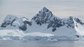
Wilhelmina Bay is dubbed "Whale-mina Bay" for its large number of humpback whales. It is a popular destination for tourist expedition ships to Antarctica thanks to its abundant whale population and spectacular scenery. The bay is surrounded by steep cliffs full of snow and glaciers. An almost perfect pyramid-shaped peak towers over the water.[2]
References
-
 A kayaker watches whales in Wilhelmina Bay
 -
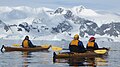 Kayakers in Wilhelmina Bay
 -
 Nautical chart showing Wilhelmina Bay
 -
 Expedition vessel Akademik Ioffe sailing into Wilhelmina Bay in January 2014
 -
 Wilhelmina Bay
 -
 A tourist Zodiac has a close encounter with a humpback whale in Wilhelmina Bay
 -
 Tourists watch a humpback whale dive in Wilhelmina Bay
 -
 A kayaker watches a humpback whale in Wilhelmina Bay


64°38′S 62°10′W / 64.633°S 62.167°W

This Danco Coast location article is a stub. You can help Wikipedia by expanding it. |