Wivenhoe Pocket
Appearance
27°25′55″S 152°37′5″E / 27.43194°S 152.61806°E
| Wivenhoe Pocket Somerset Region, Queensland | |||||||||||||||
|---|---|---|---|---|---|---|---|---|---|---|---|---|---|---|---|
 | |||||||||||||||
| Population | 498 (2011 census)[1] | ||||||||||||||
| Postcode(s) | 4306 | ||||||||||||||
| LGA(s) | Somerset Region | ||||||||||||||
| State electorate(s) | Nanango | ||||||||||||||
| Federal division(s) | Dickson | ||||||||||||||
| |||||||||||||||
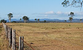
Wivenhoe Pocket is a rural suburb of Somerset Region, Queensland, Australia.[2] At the 2011 Australian Census the suburb recorded a population of 498.[1]
History
Wivenhoe Pocket was named after an early pastoral run managed by Edmund Blucher Uhr, who named it after the town of Wivenhoe in Essex, England.[2]
References
- ^ a b Australian Bureau of Statistics (31 October 2012). "Wivenhoe Pocket (State Suburb)". 2011 Census QuickStats. Retrieved 8 August 2014.
- ^ a b "Wivenhoe Pocket (entry 44936)". Queensland Place Names. Queensland Government. Retrieved 28 August 2015.
External links
![]() Media related to Wivenhoe Pocket, Queensland at Wikimedia Commons
Media related to Wivenhoe Pocket, Queensland at Wikimedia Commons
