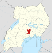
Wobulenzi
Wobulenzi
Wobulenzi Municipality | |
|---|---|
| Country | |
| Region | Central Uganda |
| District | Luweero District |
| Population (2011 Estimate) | |
| • Total | 23,700 |
Wobulenzi is a town in Luweero District in Central Uganda.
Location
Wobulenzi is located approximately 57 kilometres (35 mi), by road, north of Kampala, Uganda's capital and largest city, on the highway to Masindi.[1] The road is a busy, all-weather tarmac highway. The coordinates of the town are: 00 43 12N, 32 31 48E (Latitude:0.7200; Longitude:32.5300).
Overview
Wobulenzi is one of the municipalities in Luweero District, the others being:
- Luweero - The district headquarters, about 17 kilometres (11 mi), north of Wobulenzi.
- Bombo - About 22 kilometres (14 mi), south of Wobulenzi.
- Bamunanika - About 14.5 kilometres (9.0 mi), east of Wobulenzi.
- Ziroobwe - About 26 kilometres (16 mi), east of Wobulenzi.
Administrative structure
The town is administered by Wobulenzi town Council headed by the Mayor, the Town Clerk and Councilors. The Town Council is divided into five (5) Parishes namely:[2]
- Wobulenzi East Parish
- Wobulenzi West Parish
- Bukalasa Parish
- Katikamu Parish
- Wobulenzi Central Parish.
Population
The population of Wobulenzi was estimated at 18,846 in the 2002 national census. In 2008, the Uganda Bureau of Statistics (UBOS), estimated the population of the town at 21,900.[3] In 2011, UBOS estimated the mid-year population of Wobulenzi at 23,700.[4]
Landmarks
In Wobulenzi or near the town there are several landmarks, including the following:
- The offices of Wobulenzi Town Council
- Wobulenzi Central Market
- A branch of Centenary Bank
- The Kampala-Masindi Highway passes through the middle of town.
- The Wobulenzi-Kasawo Road - The road makes a T-junction with the Kampala-Masindi Highway at Wobulenzi and continues east, through Bamunanika, Ziroobwe and Kasawo, before it joints the Kampala-Kayunga Road at Kikwanda.

