
Yangmingshan
| Yangmingshan National Park | |
|---|---|
 Seven Star Mountain with hot springs on the side | |
| Lua error in Module:Location_map at line 526: Unable to find the specified location map definition: "Module:Location map/data/Yang-Ming-Shan-Naional-Park-Map-Taiwan.png" does not exist. | |
| Location | Taiwan |
| Nearest city | Taipei (majority of park within city limits) |
| Area | 113.38 km²[1] |
| Established | September 16, 1985 |
| Yangmingshan | |||||||||||
|---|---|---|---|---|---|---|---|---|---|---|---|
| Traditional Chinese | 陽明山國家公園 | ||||||||||
| |||||||||||
Yangmingshan National Park (Chinese: 陽明山國家公園; pinyin: Yángmíngshān Guójiā Gōngyuán) is one of the nine national parks in Taiwan, located between Taipei and New Taipei City. The districts that house parts of the park grounds include Taipei's Beitou and Shilin Districts; and New Taipei's Wanli, Jinshan and Sanzhi Districts. The National Park is famous for its cherry blossoms, hot springs, sulfur deposits, fumaroles, venomous snakes, and hiking trails, including Taiwan's tallest dormant volcano, Seven Star Mountain (1,120 m).
History
This mountain range was originally called Grass Mountain (Chinese: 草山; Pe̍h-ōe-jī: Chháu-soaⁿ) during the Qing Dynasty, in reference to Datun Mountain (大屯山; Tōa-tūn-soaⁿ). Officials during this period were worried about thieves stealing sulfur from the rich sulfur deposits in the area so they would regularly set fire to the mountain. Thus, only grass and not trees could be seen.
Daiton National Park (Japanese: 大屯国立公園), Taiwan's first national park, was one of three National Parks designated by Governor-General of Taiwan Seizō Kobayashi during Japanese rule in 1937.
In 1950, President Chiang Kai-shek, in order to commemorate the Ming Dynasty scholar Wang Yangming renamed the Grass Mountain to Yangmingshan. In 1962, the then Taiwan Provincial Bureau of Public Works began to plan the Yangmingshan National Park. The initial planning area was 28,400 hectares, including Mount Guanyin and the Tatun Volcano Group.
Landscape and geology
Different from the high mountain national parks, Yangmingshan National Park has a lower elevation. Even though mountain elevations range from only 200–1120 meters, beautiful landscapes such as ridges, valleys, lakes, waterfalls and basins are abundant. Andesite rocks make up most of the area's geology.[2]
Flora and fauna
Due to the effects of post-volcanic activity and precipitation, soil in the region is highly acidic. With the influence of the northeast monsoon and the area's microclimates, winter temperatures are much lower than the surrounding areas.[3] The above factors cause the vegetation to differ from those in other regions at the same latitude. Some medium and high altitude plants can be found here such as Bird-lime Tree and Hairy Japanese Maple. Vegetation groups can be divided into subtropical monsoon rain forests, temperate evergreen broadleaf forests and mountain ridge grasslands. There are 1360 species of vascular bundle plants in the region.[4] Some of the common ones are Red Nanmu, Large-leaved Machilus, Formosan Sweet Gum, Taiwan Cherry, Mori cleyera and Dark Spotted Cherry. The most famous is Taiwan Isoetes in Menghuan pond, an aquatic fern only found in Taiwan. Mt. Datun is one of the most well known places to see some of the 168 different species of butterflies in northern Taiwan. The best time to view the butterflies is from May to August. The most common ones are from the Families Papilionidae, Danainae and Nymphalidae. There are also 122 species of birds in the region.[5]
Historical and cultural sites
- Chinese Culture University
- Grass Mountain Chateau - Summer residence of Chiang Kai-shek
- Yangmingshuwu - Former Kuomintang Party Archives
- Taipei European School
- Chung-Shan Building - Meeting place of the now defunct National Assembly of the Republic of China
- Former Yangmingshan American Military Housing
- Guangfu Building - Built in 1971 in Northern Chinese palace style architecture to commemorate the Xinhai Revolution.[6]
- Yangmingshan No.1 Public Cemetery - Contains the graves of Sun Fo and Homer Lea.[7]
- Wuchih Mountain Military Cemetery
- Tomb of Yu Youren
- Home and grave of famous writer Lin Yutang
- Tomb of Puru, painter, educator and cousin of China's last emperor Puyi.[8]
Gallery
-
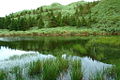 Dream Lake.
 -
-
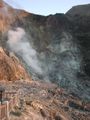 Closer view of fumarole on Seven Star Mountain.
 -
 Chung-Shan Building in Yangmingshan.
 -
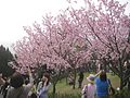
 Chinese Pavilion and Cherry Blossom.
 -
 Guangfu Building.
 -
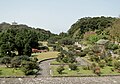 A park near the entrance.
 -
 Statue of Chiang Kai-shek in the park.


See also
References
- ^ 各國家公園基本資料表 (PDF) (in Chinese). Construction and Planning Agency, Ministry of the Interior, R.O.C.(Taiwan). June 6, 2014. Retrieved October 23, 2014.
- ^ http://eem.pcc.gov.tw/eem/node/29667
- ^ "http://np.cpami.gov.tw/english/index.php?option=com_content&view=article&id=2636:yangmingshan&catid=78:multimedia&Itemid=99".
{{cite web}}: External link in|title= - ^ "http://www.ymsnp.gov.tw/html/ENG/05planner/pla_a01_main.asp?sn=5".
{{cite web}}: External link in|title= - ^ http://ezfun.coa.gov.tw/ezgo_eng/ebook/ebook02.pdf
- ^ Guangfu Building Overview
- ^ YC-Wang, Daal,. "荷馬李將軍夫婦靈骨厝葬 - VCenter:影音分享網站(Video Sharing Website)".
{{cite web}}: CS1 maint: extra punctuation (link) CS1 maint: multiple names: authors list (link) - ^ "個人簡歷".
External links
25°10′00″N 121°33′52″E / 25.16667°N 121.56444°E
| International | |
|---|---|
| National | |