Mautby
| Mautby | |
|---|---|
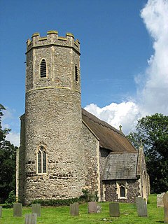
 Ss Peter & Paul, Mautby | |
Location within Norfolk | |
| Area | 16.60 km2 (6.41 sq mi) |
| Population | 383 (2011) |
| • Density | 23/km2 (60/sq mi) |
| OS grid reference | TG 479 123 |
| Civil parish |
|
| District | |
| Shire county | |
| Region | |
| Country | England |
| Sovereign state | United Kingdom |
| Post town | GREAT YARMOUTH |
| Postcode district | NR29 |
| Police | Norfolk |
| Fire | Norfolk |
| Ambulance | East of England |
Mautby is a village and civil parish in the English county of Norfolk, in the East Flegg Hundred. The parish comprises a largely rural area along the north bank of the River Bure, and also includes the small villages of Runham and Thrigby. It is located some 6 mi (9.7 km) northwest of the town of Great Yarmouth and 19 mi (31 km) east of the city of Norwich.[1][2]
The civil parish has an area of 16.6 km2 (6.4 sq mi) and in the 2001 census had a population of 395 in 145 households, the population reducing to 383 at the 2011 Census.[3] For the purposes of local government, the parish falls within the district of Great Yarmouth.[4]
The parish churches of Mautby and Runham are both dedicated to St Peter and St Paul; Thrigby's dedication is to St Mary. All three churches are Grade II* listed.[citation needed]
Notes[edit]
- ^ Ordnance Survey (2005). OS Explorer Map OL40 - The Broads; ISBN 0-319-23769-9
- ^ "Key to English Place-names". kepn.nottingham.ac.uk.
- ^ "Civil Parish population 2011". Retrieved 24 August 2015.
- ^ Office for National Statistics & Norfolk County Council (2001). Census population and household counts for unparished urban areas and all parishes. Retrieved 2 December 2005.
External links[edit]
- SS Peter and Paul's on the European Round Tower Churches website
- Map sources for Mautby.
- Map sources for Runham.
- Map sources for Thrigby.
- Information from Genuki Norfolk on Mautby.
- Information from Genuki Norfolk on Runham.
- Information from Genuki Norfolk on Thrigby.
- Runham village web site

