
Nunnington
| Nunnington | |
|---|---|
 Nunnington from the air in 2005 | |
.svg) Nunnington Location within North Yorkshire | |
| Population | 361 (2011 census)[1] |
| OS grid reference | SE 666 793 |
| Unitary authority | |
| Ceremonial county | |
| Region | |
| Country | England |
| Sovereign state | United Kingdom |
| Post town | YORK |
| Postcode district | YO62 |
| Police | North Yorkshire |
| Fire | North Yorkshire |
| Ambulance | Yorkshire |
| UK Parliament | |
Nunnington is a village and civil parish in North Yorkshire, England. The River Rye runs through. Its population, including Stonegrave, taken at the 2011 census was 361.[1] It is rich in listed historic buildings.
History
[edit]Nunnington Hall is a Grade I listed mansion owned by the National Trust and open to the public. The village has 28 other houses and features listed Grade II, including an early 18th-century bridge over the river.[2]
Church
[edit]The parish church dedicated to All Saints and St James is a Grade I listed building. The nave and chancel date from the late 13th century and the tower from 1672. The tower, porch and vestry were rebuilt in 1883–1884. There is a fine 17th-century pulpit.[3][4]
There is a tomb in the church said to belong to a man named Peter Loschy, who slew a dragon in Loschy Wood. In fact, the tomb belongs to Sir Walter de Teyes of Stonegrave Manor.[5]
Notable residents
[edit]Former residents of Nunnington have included the writers Annie Keary (1825–1879) and Eliza Harriett Keary (1827–1918) in the 1840s, while their father William Keary (died 1859) was rector.[6] Annie Keary's children's book Mia and Charlie; or a Week's Holiday at Ryedale Rectory (London/Winchester, 1855) recounts the story of a Proud Lady of "Nunningham", who haunts the hall.[7]
Sir Herbert Read, the anarchist poet and critic, was born at nearby Muscoates in 1893 and lived at Muscoates Grange Farm.[8]
Amenities
[edit]School
[edit]The nearest schools are at Kirkbymoorside and Malton.[9] Nunnington Church of England School dwindled and closed seemingly before the Second World War.[10]
Public transport
[edit]Nunnington railway station lay 1 mile (1.6 km) west of the village. It closed to passengers in 1953.[11] The nearest railway station is at Malton (10.2 miles, 16.4 km). There are no public bus services for the village at present.[12]
Gallery
[edit]-
 All Saints' and St. James' Church
 -
 Nunnington Hall
 -
 Looking to the River Rye from West Ness
 -
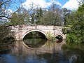 Nunnington Bridge


.jpg)
References
[edit]- ^ a b UK Census (2011). "Local Area Report – Nunnington Parish (1170217276)". Nomis. Office for National Statistics. Retrieved 16 March 2018.
- ^ English Heritage Retrieved 22 October 2010
- ^ Listing document
- ^ Further church history detail
- ^ "All Saints Church, Nunnington and the Dragon of Loschy Wood – Mysterious Britain & Ireland". Mysterious Britain & Ireland. Retrieved 27 August 2014.
- ^ Lusting, Jodi (May 2006) [2004]. "Keary, Eliza Harriett (baptised 1827, died 1918)". Oxford Dictionary of National Biography (online ed.). Oxford University Press. Retrieved 22 October 2010. (Subscription or UK public library membership required.)
- ^ A History of the County of York North Riding: Volume 1 (1914) Retrieved 22 October 2010.
- ^ 1901 Census.
- ^ Retrieved 9 May 2019.
- ^ Photographs. Retrieved 9 May 2019.
- ^ Retrieved 22 October 2010.
- ^ Retrieved 9 May 2019.
External links
[edit]![]() Media related to Nunnington at Wikimedia Commons
Media related to Nunnington at Wikimedia Commons