
Mojave Desert: Difference between revisions
No edit summary |
cleanup refs |
||
| Line 42: | Line 42: | ||
}} |
}} |
||
The '''Mojave Desert''' ({{IPAc-en|m|oʊ|ˈ|h|ɑː|v|i|,_|m|ə|-}} {{respell|moh|HAH|vee|,_|mə|-}};{{refn|{{Citation |last=Jones |first=Daniel |author-link=Daniel Jones (phonetician) |title=English Pronouncing Dictionary |editor1=Peter Roach |editor2=James Hartmann |editor3=Jane Setter |place=Cambridge |publisher=Cambridge University Press |orig-year=1917 |year=2003 |isbn=978-3-12-539683-8 }}}}{{refn|{{cite Dictionary.com|Mojave}}}}<ref>{{cite OED|Mojave|id=120733}}</ref> {{lang-mov|Hayikwiir Mat'aar}}; {{lang-es|Desierto de Mojave}}) is a [[xeric]] [[desert]] in the [[rain shadow]] of the [[Sierra Nevada]] mountains in the [[Southwestern United States]].<ref>{{cite web |title=The Mojave Desert |url=https://www.blueplanetbiomes.org/mojave_desert.php#:~:text=The%20Mojave%20Desert%20lies%20in,cold%20air%20in%20the%20mountains. |url-status=live |website=Blue Planet Biomes}}</ref><ref name=":0">{{cite web |title=Mojave Desert |url=https://www.worldwildlife.org/ecoregions/na1308#:~:text=The%20Mojave%20Desert%20is%20the,division%20of%20the%20Sonoran%20desert. |url-status=live |website=World Wildlife Fund}}</ref> It is named for the [[Indigenous peoples of the Americas|indigenous]] [[Mohave people|Mojave]] people. It is located primarily in southeastern [[California]] and southwestern [[Nevada]], with small portions extending into [[Arizona]] and [[Utah]].<ref name=":1"> |
The '''Mojave Desert''' ({{IPAc-en|m|oʊ|ˈ|h|ɑː|v|i|,_|m|ə|-}} {{respell|moh|HAH|vee|,_|mə|-}};{{refn|{{Citation |last=Jones |first=Daniel |author-link=Daniel Jones (phonetician) |title=English Pronouncing Dictionary |editor1=Peter Roach |editor2=James Hartmann |editor3=Jane Setter |place=Cambridge |publisher=Cambridge University Press |orig-year=1917 |year=2003 |isbn=978-3-12-539683-8 }}}}{{refn|{{cite Dictionary.com|Mojave}}}}<ref>{{cite OED|Mojave|id=120733}}</ref> {{lang-mov|Hayikwiir Mat'aar}}; {{lang-es|Desierto de Mojave}}) is a [[xeric]] [[desert]] in the [[rain shadow]] of the [[Sierra Nevada]] mountains in the [[Southwestern United States]].<ref>{{cite web |title=The Mojave Desert |url=https://www.blueplanetbiomes.org/mojave_desert.php#:~:text=The%20Mojave%20Desert%20lies%20in,cold%20air%20in%20the%20mountains. |url-status=live |website=Blue Planet Biomes}}</ref><ref name=":0">{{cite web |title=Mojave Desert |url=https://www.worldwildlife.org/ecoregions/na1308#:~:text=The%20Mojave%20Desert%20is%20the,division%20of%20the%20Sonoran%20desert. |url-status=live |website=World Wildlife Fund}}</ref> It is named for the [[Indigenous peoples of the Americas|indigenous]] [[Mohave people|Mojave]] people. It is located primarily in southeastern [[California]] and southwestern [[Nevada]], with small portions extending into [[Arizona]] and [[Utah]].<ref name=":1">{{cite encyclopedia|entry=Mojave Desert|encyclopedia=Encyclopedia Britannica|date=March 25, 2021|url=https://www.britannica.com/place/Mojave-Desert|access-date=July 22, 2021}}</ref><ref name=":0" /> |
||
[[File:Joshua Tree NP - Joshua Tree 2.jpg|thumb|The Joshua tree (''[[Yucca brevifolia]]'') is [[endemism|endemic]] and exclusive to the Mojave Desert.<ref>{{cite web |title=Mojave Desert Biome |url=https://www.blueplanetbiomes.org/mojave_desert.php#:~:text=The%20Mojave%20Desert%20lies%20in,cold%20air%20in%20the%20mountains. |url-status=live |access-date=July 23, 2021 |website=Blue Planet Biomes}}</ref>]] |
[[File:Joshua Tree NP - Joshua Tree 2.jpg|thumb|The Joshua tree (''[[Yucca brevifolia]]'') is [[endemism|endemic]] and exclusive to the Mojave Desert.<ref>{{cite web |title=Mojave Desert Biome |url=https://www.blueplanetbiomes.org/mojave_desert.php#:~:text=The%20Mojave%20Desert%20lies%20in,cold%20air%20in%20the%20mountains. |url-status=live |access-date=July 23, 2021 |website=Blue Planet Biomes}}</ref>]] |
||
Along with the [[Sonoran Desert|Sonoran]], [[Chihuahuan Desert|Chihuahuan]], and [[Great Basin Desert|Great Basin]] deserts, a larger North American Desert is formed. Of these, the Mojave is the smallest and driest. The Mojave Desert is bordered to the west by the Sierra Nevada mountain range and the [[California montane chaparral and woodlands]], and to the south and east by the Sonoran Desert, although the boundaries to the east of the Mojave Desert are less distinctive than the other boundaries as there is no distinctive presence of an indicator species, such as the [[Yucca brevifolia|Joshua tree]] (''Yucca brevifolia''),<ref name=":3">Rundel |
Along with the [[Sonoran Desert|Sonoran]], [[Chihuahuan Desert|Chihuahuan]], and [[Great Basin Desert|Great Basin]] deserts, a larger North American Desert is formed. Of these, the Mojave is the smallest and driest. The Mojave Desert is bordered to the west by the Sierra Nevada mountain range and the [[California montane chaparral and woodlands]], and to the south and east by the Sonoran Desert, although the boundaries to the east of the Mojave Desert are less distinctive than the other boundaries as there is no distinctive presence of an indicator species, such as the [[Yucca brevifolia|Joshua tree]] (''Yucca brevifolia''),<ref name=":3">{{cite book|last1=Rundel|first1=Philip W|first2=Arthur C|last2=Gibson|title=Ecological communities and processes in a Mojave Desert ecosystem|publisher=Cambridge University Press|year=2005}}</ref> which is endemic to the Mojave Desert. The Mojave Desert is distinguished from the Sonoran Desert and other deserts adjacent to it by its warm temperate climate, as well as [[flora and fauna]] such as [[Olneya|ironwood]] (''Olneya'' ''tesota''), [[Parkinsonia florida|blue Palo Verde]] (''Parkinsonia florida''), [[Justicia californica|chuparosa]] (''Justicia californica''), [[Menodora spinescens|spiny menodora]] (''Menodora spinescens''), [[desert senna]] (''Cassia armata''), [[Psorothamnus arborescens|California dalea]] (''Psorothamnus arborescens''), and [[Acamptopappus|goldenhead]] (''Acamptopappus shockleyi''). With these other factors, the extent of these plants generally serves to differentiate the Mojave from the nearby Sonoran desert.<ref name=":0" /> The Mojave Desert displays typical [[basin and range topography]], that is, generally having a pattern of a series of parallel mountain ranges and valleys. The Mojave Desert contains various [[silver]], [[tungsten]], [[iron]] and [[gold]] deposits.<ref name=":5"/> It is also the site of [[Death Valley]], which is the lowest elevation in North America. The Mojave Desert is often colloquially called the "high desert", as most of it lies between {{Convert|610 and 1,220|m|abbr=on|sp=us}}. |
||
The spelling ''Mojave'' originates from the Spanish language while the spelling ''Mohave'' comes from modern English. Both are used today, although the [[Mohave people|Mojave]] Tribal Nation officially uses the spelling ''Mojave''; the word is a shortened form of {{lang|mov|Hamakhaave}}, their [[Exonym and endonym|endonym]] in their native language, which means "beside the water".<ref>{{cite web|title=American Indian History|url=http://www.bigorrin.org/mojave_kids.htm}}</ref> |
The spelling ''Mojave'' originates from the Spanish language while the spelling ''Mohave'' comes from modern English. Both are used today, although the [[Mohave people|Mojave]] Tribal Nation officially uses the spelling ''Mojave''; the word is a shortened form of {{lang|mov|Hamakhaave}}, their [[Exonym and endonym|endonym]] in their native language, which means "beside the water".<ref>{{cite web|title=American Indian History|url=http://www.bigorrin.org/mojave_kids.htm}}</ref> |
||
| Line 59: | Line 59: | ||
The Mojave Desert is bordered by the [[San Andreas Fault|San Andreas]] and the [[Garlock Fault|Garlock]] faults to the Southwest and to the North. The mountains elevated along the length of the San Andreas fault provide a clear border between the Mojave desert and the coastal regions to the West.<ref name=":2" /> The Garlock fault separates the Mojave Desert from the Sierra Nevada and [[Tehachapi Mountains|Tehachapi]] mountains, which also provides a natural border to the Mojave Desert. There are also abundant [[alluvial fan]]s, which are called [[Bajada (geography)|bajadas]], which form around the mountains within the Mojave desert and extend down toward the low altitude basins,<ref name=":3" /> which contain dried lake beds called playas, where water generally collects and evaporates, leaving large volumes of salt. These playas include [[Rogers Dry Lake]], and [[Naval Air Weapons Station China Lake|China Lake]]. Dry lakes are a noted feature of the Mojave landscape.<ref name=":0" /> The Mojave Desert is also home to the [[Devils Playground]], about {{convert|40|mi|km}} of dunes and salt flats going in a northwest-southeasterly direction. The Devil's Playground is a part of the Mojave National Preserve and is between the town of [[Baker, California]] and [[Providence Mountains]]. The [[Cronese Mountains]] are within the Devil's Playground. |
The Mojave Desert is bordered by the [[San Andreas Fault|San Andreas]] and the [[Garlock Fault|Garlock]] faults to the Southwest and to the North. The mountains elevated along the length of the San Andreas fault provide a clear border between the Mojave desert and the coastal regions to the West.<ref name=":2" /> The Garlock fault separates the Mojave Desert from the Sierra Nevada and [[Tehachapi Mountains|Tehachapi]] mountains, which also provides a natural border to the Mojave Desert. There are also abundant [[alluvial fan]]s, which are called [[Bajada (geography)|bajadas]], which form around the mountains within the Mojave desert and extend down toward the low altitude basins,<ref name=":3" /> which contain dried lake beds called playas, where water generally collects and evaporates, leaving large volumes of salt. These playas include [[Rogers Dry Lake]], and [[Naval Air Weapons Station China Lake|China Lake]]. Dry lakes are a noted feature of the Mojave landscape.<ref name=":0" /> The Mojave Desert is also home to the [[Devils Playground]], about {{convert|40|mi|km}} of dunes and salt flats going in a northwest-southeasterly direction. The Devil's Playground is a part of the Mojave National Preserve and is between the town of [[Baker, California]] and [[Providence Mountains]]. The [[Cronese Mountains]] are within the Devil's Playground. |
||
Relatively, there is not much [[river]]ine activity in the Mojave Desert. The intermittent [[Mojave River]], which begins on the San Bernardino mountains and disappears deeper into the Mojave Desert flows through the Mojave generally underground. The [[Amargosa River]] also flows partly through the Mojave Desert along a southward path. The Manix, Mojave, and the Little Mojave lakes are all large but shallow.<ref |
Relatively, there is not much [[river]]ine activity in the Mojave Desert. The intermittent [[Mojave River]], which begins on the San Bernardino mountains and disappears deeper into the Mojave Desert flows through the Mojave generally underground. The [[Amargosa River]] also flows partly through the Mojave Desert along a southward path. The Manix, Mojave, and the Little Mojave lakes are all large but shallow.<ref name=":3"/>{{rp|7}} [[Soda Lake (San Bernardino County)|Soda Lake]] is the principal saline basine of the Mojave desert. [[Spring (hydrology)|Natural springs]] are typically rare throughout the Mojave desert,<ref name=":3"/>{{rp|19}} however, there are two notable springs, [[Ash Meadows National Wildlife Refuge|Ash Meadows]], and [[Oasis Valley]]. Ash Meadows is formed from several other springs, which all draw from deep underground. Oasis Valley draws from the nearby Amargosa River. |
||
The Mojave Desert is also a source of various minerals and metallic materials. The deposits of gold, tungsten, and silver have been mined frequently prior to the [[World War II|Second World War]].<ref name=": |
The Mojave Desert is also a source of various minerals and metallic materials. The deposits of gold, tungsten, and silver have been mined frequently prior to the [[World War II|Second World War]].<ref name=":5" /> Additionally, there have been deposits of [[copper]], [[tin]], [[Lead zirconate titanate|lead-zinc]], [[manganese]], [[iron]], and various [[Radioactive decay|radioactive substances]] but they have not been mined for [[Economy|commercial]] use.<ref name=":5" /> |
||
== Climate == |
== Climate == |
||
| Line 315: | Line 315: | ||
== Prehistoric formation == |
== Prehistoric formation == |
||
The Mojave Desert was likely under shallow water for most of the time of its formation.<ref |
The Mojave Desert was likely under shallow water for most of the time of its formation.<ref name=":3"/>{{rp|21}}<ref name=":5"/> |
||
</ref> Under this shallow coat of water, a large volume of sedimentary processes were likely taking place, causing in large deposits of limestones, silicates, and dolomites. During the Paleozoic Era, the area that is now the Mojave was again likely submerged under a greater sea.<ref name=":5">Dibledee |
</ref> Under this shallow coat of water, a large volume of sedimentary processes were likely taking place, causing in large deposits of limestones, silicates, and dolomites. During the Paleozoic Era, the area that is now the Mojave was again likely submerged under a greater sea.<ref name=":5">{{cite web|last=Dibledee|first=TW Jr|year=1967| |
||
title=Areal geology of the western Mojave Desert, California|id=Professional Paper 522|url=https://pubs.er.usgs.gov/publication/pp522|page=115-116,124}}</ref> During the Mesozoic era, major tectonic activities such as [[thrust fault]]ing and [[Fold (geology)|folding]] resulted in distinctive shaping as well as [[Igneous intrusion|intrusion]].<ref name=":3" /><ref name=":5" /> During the [[Cenozoic]], more tectonic deformation occurred whilst the Mojave was partly submerged. Major volcanic activity is thought to have occurred during the [[Oligocene]]. Large downpours during the [[Miocene]] likely significantly eroded the rock in the Mojave and accelerated [[Deposition (geology)|deposition]].<ref name=":5" /> |
|||
== Tourism == |
== Tourism == |
||
| Line 331: | Line 332: | ||
== Flora == |
== Flora == |
||
The flora of the Mojave desert are helpful in determining the extents of the Mojave desert where there may not be distinctive geophysical boundaries,<ref name=":0" /> the Mojave desert consists of various [[Endemism|endemic]] plant species, notably the [[Yucca brevifolia|Joshua Tree]], which is a particularly notable endemic and indicator species of the desert. There are more endemic flora of the Mojave desert than almost anywhere in the world.<ref name=":0" /> Mojave Desert flora is not a [[vegetation type]], although the plants in the area have evolved in isolation because of the physical barriers of the Sierra Nevadas and the Colorado Plateau. Predominant plants of the Mojave desert include [[Atriplex polycarpa|all-scale]] (''Atriplex polycarpa''), [[Larrea tridentata|creosote bush]] (''Larrea tridentata''), [[Encelia farinosa|brittlebush]] (''Encelia farinosa''), [[Atriplex hymenelytra|desert holly]] (''Atriplex hymenelytra''), [[Ambrosia salsola|white burrobush]] (Hymenoclea salsola), and most notably, the Joshua tree (Yucca brevifolia). Additionally, the Mojave desert is also home to various species of cacti, such as [[Cylindropuntia echinocarpa|silver cholla]] (''Cylindropuntia echinocarpa''), [[Opuntia phaeacantha|Mojave prickly pear]] (''O. erinacea''), [[Opuntia basilaris|beavertail cactus]] (''O. basilaris''), and [[Echinocactus polycephalus|many-headed barrel cactus]] (''Echinocactus polycephalus''). Less common but distinctive plants of the Mojave desert include [[Olneya|ironwood]] (''Olneya'' ''tesota''), [[Parkinsonia florida|blue Palo Verde]] (''Parkinsonia Florida''), [[Justicia californica|chuparosa]] (''Justicia californica''), [[Menodora spinescens|spiny menodora]] (''Menodora spinescens''), [[desert senna]] (''Cassia armata''), [[Psorothamnus arborescens|California dalea]] (''Psorothamnus arborescens''), and [[Acamptopappus|goldenhead]] (''Acamptopappus shockleyi''). The Mojave desert is generally abundant in winter annuals.<ref |
The flora of the Mojave desert are helpful in determining the extents of the Mojave desert where there may not be distinctive geophysical boundaries,<ref name=":0" /> the Mojave desert consists of various [[Endemism|endemic]] plant species, notably the [[Yucca brevifolia|Joshua Tree]], which is a particularly notable endemic and indicator species of the desert. There are more endemic flora of the Mojave desert than almost anywhere in the world.<ref name=":0" /> Mojave Desert flora is not a [[vegetation type]], although the plants in the area have evolved in isolation because of the physical barriers of the Sierra Nevadas and the Colorado Plateau. Predominant plants of the Mojave desert include [[Atriplex polycarpa|all-scale]] (''Atriplex polycarpa''), [[Larrea tridentata|creosote bush]] (''Larrea tridentata''), [[Encelia farinosa|brittlebush]] (''Encelia farinosa''), [[Atriplex hymenelytra|desert holly]] (''Atriplex hymenelytra''), [[Ambrosia salsola|white burrobush]] (Hymenoclea salsola), and most notably, the Joshua tree (Yucca brevifolia). Additionally, the Mojave desert is also home to various species of cacti, such as [[Cylindropuntia echinocarpa|silver cholla]] (''Cylindropuntia echinocarpa''), [[Opuntia phaeacantha|Mojave prickly pear]] (''O. erinacea''), [[Opuntia basilaris|beavertail cactus]] (''O. basilaris''), and [[Echinocactus polycephalus|many-headed barrel cactus]] (''Echinocactus polycephalus''). Less common but distinctive plants of the Mojave desert include [[Olneya|ironwood]] (''Olneya'' ''tesota''), [[Parkinsonia florida|blue Palo Verde]] (''Parkinsonia Florida''), [[Justicia californica|chuparosa]] (''Justicia californica''), [[Menodora spinescens|spiny menodora]] (''Menodora spinescens''), [[desert senna]] (''Cassia armata''), [[Psorothamnus arborescens|California dalea]] (''Psorothamnus arborescens''), and [[Acamptopappus|goldenhead]] (''Acamptopappus shockleyi''). The Mojave desert is generally abundant in winter annuals.<ref name=":3"/>{{rp|11}} The plants of the Mojave desert each generally correspond to an individual geographic feature. As such, there are distinctive flora communities within the desert. |
||
<gallery> |
<gallery> |
||
| Line 342: | Line 343: | ||
== Fauna == |
== Fauna == |
||
A good portion of the fauna of the Mojave Desert extends into the neighboring Sonoran and Great Basin deserts. The animal species of the Mojave Desert have generally less endemics than its flora. However, endemic fauna of the Mojave Desert include [[Ammopelmatus kelsoensis|Kelso Dunes jerusalem cricket]] (''Ammopelmatus kelsoensis),'' the [[Eremopedes kelsoensis|Kelso Dunes shieldback katydid]] (''Eremopedes kelsoensis''), the [[Mohave ground squirrel]] (''Spermophilus Mohavensis'') and [[Amargosa vole]] (''Microtus californicus scirpensis'').<ref>Neuwald |
A good portion of the fauna of the Mojave Desert extends into the neighboring Sonoran and Great Basin deserts. The animal species of the Mojave Desert have generally less endemics than its flora. However, endemic fauna of the Mojave Desert include [[Ammopelmatus kelsoensis|Kelso Dunes jerusalem cricket]] (''Ammopelmatus kelsoensis),'' the [[Eremopedes kelsoensis|Kelso Dunes shieldback katydid]] (''Eremopedes kelsoensis''), the [[Mohave ground squirrel]] (''Spermophilus Mohavensis'') and [[Amargosa vole]] (''Microtus californicus scirpensis'').<ref>{{cite journal|last=Neuwald|first=JL|year=2010|title=Population isolation exacerbates conservation genetic concerns in the endangered Amargosa vole, ''Microtus californicus scirpensis''|journal=Biological Conservation|volume=143|pages=2028-2038}}</ref> The [[Mojave fringe-toed lizard]] (''Uma Scopari''a) is not endemic, but almost completely limited to the Mojave desert. Notable species of the Mojave desert include the [[desert tortoise]] (''Gopherus agassizii''), which has adapted considerably to the conditions of the Mojave Desert and deserts in general.<ref name=":0" /> Various other species are particularly common in the Mojave Desert, such as the [[LeConte's thrasher]] (''Toxostoma lecontei''), [[Western banded gecko|banded gecko]] (''Coleonyx variegatus''), [[desert iguana]] (Dipsosaurus dorsalis), [[chuckwalla]] (''Sauromalus obesus''), and [[regal horned lizard]] (''Phrynosoma solare''). Species of snake include the [[rosy boa]] (''Lichanura trivirgata''), [[Salvadora hexalepis|Western patch-nosed snake]] (''Salvadora hexalepis''), and [[Crotalus scutulatus|Mojave rattlesnake]] (''Crotalus scutulatus''). |
||
[[File:Desert tortoise (G. agassizii) - Flickr - smashtonlee05.jpg|thumb|A desert tortoise, which can be found in the Mojave Desert]] |
[[File:Desert tortoise (G. agassizii) - Flickr - smashtonlee05.jpg|thumb|A desert tortoise, which can be found in the Mojave Desert]] |
||
| Line 350: | Line 351: | ||
=== 2009 litigation === |
=== 2009 litigation === |
||
In 2009, U.S. District Judge [[Susan Illston]] ruled against the Bureau's proposed designation of additional off-road vehicle use allowance in the western Mojave Desert. According to the ruling, the Bureau of Land Management violated its own regulations when it designated approximately 5,000 miles (8,000 km) of [[off-roading]] routes in 2006. According to Judge Illston, the Bureau's designation was significantly "flawed because it does not contain a reasonable range of alternatives" to limit damage to sensitive habitat. Judge Illston found the bureau had inadequately analyzed the routes' impacts on air quality, soils, plant communities, riparian habitats, and sensitive species such as the endangered [[Uma scoparia|Mojave fringe-toed lizard]], pointing out that the desert and its resources are "extremely fragile, easily scarred, and slowly healed."<ref> |
In 2009, U.S. District Judge [[Susan Illston]] ruled against the Bureau's proposed designation of additional off-road vehicle use allowance in the western Mojave Desert. According to the ruling, the Bureau of Land Management violated its own regulations when it designated approximately 5,000 miles (8,000 km) of [[off-roading]] routes in 2006. According to Judge Illston, the Bureau's designation was significantly "flawed because it does not contain a reasonable range of alternatives" to limit damage to sensitive habitat. Judge Illston found the bureau had inadequately analyzed the routes' impacts on air quality, soils, plant communities, riparian habitats, and sensitive species such as the endangered [[Uma scoparia|Mojave fringe-toed lizard]], pointing out that the desert and its resources are "extremely fragile, easily scarred, and slowly healed."<ref name=wil>{{cite web|url=http://wilderness.org/content/road-routes-mojave-desert-found-illegal|title=Off-road Routes in Mojave Desert Found Illegal|website=wilderness.org|access-date=2009-10-09|archive-url=https://web.archive.org/web/20120415135954/http://wilderness.org/content/road-routes-mojave-desert-found-illegal|archive-date=2012-04-15|url-status=dead}}</ref> |
||
== Cities and regions == |
== Cities and regions == |
||
Revision as of 08:10, 9 March 2022
| Mojave Desert Hayyikwiir Mat'aar (Mohave)[1] | |
|---|---|
 Calico Basin in Red Rock Canyon National Conservation Area near Las Vegas | |
 Location in the desert Southwest | |
| Ecology | |
| Realm | Nearctic |
| Biome | Deserts and xeric shrublands |
| Borders | |
| Geography | |
| Country | United States |
| States | |
| Coordinates | 35°N 116°W / 35°N 116°W |
| Rivers | Colorado River, Mojave River |
| Conservation | |
| Conservation status | Relatively Stable/Intact[2] |
The Mojave Desert (/moʊˈhɑːvi, mə-/ moh-HAH-vee, mə-;[3][4][5] Mohave: Hayikwiir Mat'aar; Spanish: Desierto de Mojave) is a xeric desert in the rain shadow of the Sierra Nevada mountains in the Southwestern United States.[6][7] It is named for the indigenous Mojave people. It is located primarily in southeastern California and southwestern Nevada, with small portions extending into Arizona and Utah.[8][7]

Along with the Sonoran, Chihuahuan, and Great Basin deserts, a larger North American Desert is formed. Of these, the Mojave is the smallest and driest. The Mojave Desert is bordered to the west by the Sierra Nevada mountain range and the California montane chaparral and woodlands, and to the south and east by the Sonoran Desert, although the boundaries to the east of the Mojave Desert are less distinctive than the other boundaries as there is no distinctive presence of an indicator species, such as the Joshua tree (Yucca brevifolia),[10] which is endemic to the Mojave Desert. The Mojave Desert is distinguished from the Sonoran Desert and other deserts adjacent to it by its warm temperate climate, as well as flora and fauna such as ironwood (Olneya tesota), blue Palo Verde (Parkinsonia florida), chuparosa (Justicia californica), spiny menodora (Menodora spinescens), desert senna (Cassia armata), California dalea (Psorothamnus arborescens), and goldenhead (Acamptopappus shockleyi). With these other factors, the extent of these plants generally serves to differentiate the Mojave from the nearby Sonoran desert.[7] The Mojave Desert displays typical basin and range topography, that is, generally having a pattern of a series of parallel mountain ranges and valleys. The Mojave Desert contains various silver, tungsten, iron and gold deposits.[11] It is also the site of Death Valley, which is the lowest elevation in North America. The Mojave Desert is often colloquially called the "high desert", as most of it lies between 610 and 1,220 m (2,000 and 4,000 ft).
The spelling Mojave originates from the Spanish language while the spelling Mohave comes from modern English. Both are used today, although the Mojave Tribal Nation officially uses the spelling Mojave; the word is a shortened form of Hamakhaave, their endonym in their native language, which means "beside the water".[12]
Conservation status
The Mojave Desert has a relatively stable and intact conservation status. In fact, the Mojave Desert is one of the best protected distinct ecoregions in the United States,[7] as a result of the California Desert Protection Act, which established the Death Valley, Joshua Tree National Parks and the Mojave National Preserve.[13] However, the southwest and central east portions of the Mojave Desert are particularly threatened as a result of off-road vehicles, human development, and agricultural grazing.[7] The World Wildlife Fund lists the Mojave Desert as relatively "stable/intact."[7]
Human development
In recent years, human development in the Mojave desert has become increasingly present. Human development at the major urban and suburban centers of Las Vegas and Los Angeles has had an increasingly damaging effect on the wildlife of the Mojave Desert.[7] An added demand for landfill space as a result of the large metropolitan centers of Las Vegas and Los Angeles also has the real potential to drastically affect the flora and fauna of the Mojave Desert. Agricultural development along the Colorado river, which is close to the Eastern boundary of the Mojave Desert also causes habitat loss and degradation.[8][7] Areas that are particularly affected by human development include Ward Valley and Riverside country. The United States military also maintains installations in the Mojave Desert. Thus, the Mojave is a critical training location for the United States Department of Defense.[14]
Geology and physical features
The Mojave Desert is bordered by the San Andreas and the Garlock faults to the Southwest and to the North. The mountains elevated along the length of the San Andreas fault provide a clear border between the Mojave desert and the coastal regions to the West.[15] The Garlock fault separates the Mojave Desert from the Sierra Nevada and Tehachapi mountains, which also provides a natural border to the Mojave Desert. There are also abundant alluvial fans, which are called bajadas, which form around the mountains within the Mojave desert and extend down toward the low altitude basins,[10] which contain dried lake beds called playas, where water generally collects and evaporates, leaving large volumes of salt. These playas include Rogers Dry Lake, and China Lake. Dry lakes are a noted feature of the Mojave landscape.[7] The Mojave Desert is also home to the Devils Playground, about 40 miles (64 km) of dunes and salt flats going in a northwest-southeasterly direction. The Devil's Playground is a part of the Mojave National Preserve and is between the town of Baker, California and Providence Mountains. The Cronese Mountains are within the Devil's Playground.
Relatively, there is not much riverine activity in the Mojave Desert. The intermittent Mojave River, which begins on the San Bernardino mountains and disappears deeper into the Mojave Desert flows through the Mojave generally underground. The Amargosa River also flows partly through the Mojave Desert along a southward path. The Manix, Mojave, and the Little Mojave lakes are all large but shallow.[10]: 7 Soda Lake is the principal saline basine of the Mojave desert. Natural springs are typically rare throughout the Mojave desert,[10]: 19 however, there are two notable springs, Ash Meadows, and Oasis Valley. Ash Meadows is formed from several other springs, which all draw from deep underground. Oasis Valley draws from the nearby Amargosa River.
The Mojave Desert is also a source of various minerals and metallic materials. The deposits of gold, tungsten, and silver have been mined frequently prior to the Second World War.[11] Additionally, there have been deposits of copper, tin, lead-zinc, manganese, iron, and various radioactive substances but they have not been mined for commercial use.[11]
Climate
The climate of the Mojave Desert is characterized by extremes in temperatures throughout the seasons. Freezing temperatures as well as strong winds are not uncommon in the winter, as well as precipitation such as rain and snow in the mountains. In contrast, temperatures above 100 °F (38 °C) are not uncommon during the summer months.[16] There is an annual average precipitation of 2 to 6 inches (51 to 152 mm), although regions at high altitudes such as the portion of the Mojave desert in the San Gabriel mountains.[15][8] Most of the precipitation in the Mojave comes from the Pacific Cyclonic storms that are generally present passing Eastward in November to April.[15] Such storms generally bring rain and snow only in the mountainous regions, as a result of the effect of the Sierra Nevada mountains, which creates a drying effect on its leeward slopes.[15]
During the late summer months, there is also the possibility of strong thunderstorms which bring heavy showers or cloudbursts. These storms can result in flash flooding.
The Mojave Desert has not historically supported a fire regime because of low fuel loads and connectivity. However, in the last few decades, invasive annual plants such as some within the genera Bromus, Schismus and Brassica have facilitated fires by serving as a fuel bed for fires. This has significantly altered many areas of the desert. At higher elevations, fire regimes are regular but infrequent.[17]
| Climate data for Furnace Creek, Death Valley (Elevation −190 ft (−58 m)) | |||||||||||||
|---|---|---|---|---|---|---|---|---|---|---|---|---|---|
| Month | Jan | Feb | Mar | Apr | May | Jun | Jul | Aug | Sep | Oct | Nov | Dec | Year |
| Record high °F (°C) | 88 (31) |
97 (36) |
102 (39) |
113 (45) |
122 (50) |
128 (53) |
134 (57) |
127 (53) |
123 (51) |
113 (45) |
98 (37) |
88 (31) |
134 (57) |
| Mean daily maximum °F (°C) | 66.9 (19.4) |
73.3 (22.9) |
82.1 (27.8) |
90.5 (32.5) |
100.5 (38.1) |
109.9 (43.3) |
116.5 (46.9) |
114.7 (45.9) |
106.5 (41.4) |
92.8 (33.8) |
77.1 (25.1) |
65.2 (18.4) |
91.4 (33.0) |
| Mean daily minimum °F (°C) | 40.0 (4.4) |
46.3 (7.9) |
54.8 (12.7) |
62.1 (16.7) |
72.7 (22.6) |
81.2 (27.3) |
88.0 (31.1) |
85.7 (29.8) |
75.6 (24.2) |
61.5 (16.4) |
48.1 (8.9) |
38.3 (3.5) |
62.9 (17.2) |
| Record low °F (°C) | 15 (−9) |
26 (−3) |
26 (−3) |
39 (4) |
46 (8) |
54 (12) |
67 (19) |
65 (18) |
55 (13) |
37 (3) |
30 (−1) |
22 (−6) |
15 (−9) |
| Average precipitation inches (mm) | 0.39 (9.9) |
0.51 (13) |
0.30 (7.6) |
0.12 (3.0) |
0.03 (0.76) |
0.05 (1.3) |
0.07 (1.8) |
0.13 (3.3) |
0.21 (5.3) |
0.07 (1.8) |
0.18 (4.6) |
0.30 (7.6) |
2.36 (60) |
| Mean monthly sunshine hours | 217 | 226 | 279 | 330 | 372 | 390 | 403 | 372 | 330 | 310 | 210 | 186 | 3,625 |
| Source: NOAA 1981–2010 US Climate Normals [18] | |||||||||||||
| Climate data for Searchlight, Nevada. (Elevation 3,550 ft (1,080 m)) | |||||||||||||
|---|---|---|---|---|---|---|---|---|---|---|---|---|---|
| Month | Jan | Feb | Mar | Apr | May | Jun | Jul | Aug | Sep | Oct | Nov | Dec | Year |
| Record high °F (°C) | 77 (25) |
81 (27) |
90 (32) |
94 (34) |
102 (39) |
110 (43) |
111 (44) |
110 (43) |
107 (42) |
98 (37) |
86 (30) |
75 (24) |
111 (44) |
| Mean daily maximum °F (°C) | 53.7 (12.1) |
58.4 (14.7) |
65.0 (18.3) |
73.1 (22.8) |
82.5 (28.1) |
92.7 (33.7) |
97.6 (36.4) |
95.4 (35.2) |
89.0 (31.7) |
77.0 (25.0) |
63.6 (17.6) |
54.4 (12.4) |
75.2 (24.0) |
| Mean daily minimum °F (°C) | 35.6 (2.0) |
38.3 (3.5) |
41.8 (5.4) |
48.0 (8.9) |
55.9 (13.3) |
64.8 (18.2) |
71.4 (21.9) |
69.6 (20.9) |
63.9 (17.7) |
53.9 (12.2) |
43.0 (6.1) |
36.4 (2.4) |
51.9 (11.1) |
| Record low °F (°C) | 7 (−14) |
11 (−12) |
20 (−7) |
27 (−3) |
30 (−1) |
40 (4) |
52 (11) |
51 (11) |
41 (5) |
23 (−5) |
15 (−9) |
8 (−13) |
7 (−14) |
| Average precipitation inches (mm) | 0.92 (23) |
0.96 (24) |
0.77 (20) |
0.40 (10) |
0.20 (5.1) |
0.11 (2.8) |
0.91 (23) |
1.08 (27) |
0.61 (15) |
0.52 (13) |
0.43 (11) |
0.79 (20) |
7.70 (196) |
| Source: The Western Regional Climate Center[19] | |||||||||||||
| Climate data for Mount Charleston Lodge, Nevada. (Elevation 7,420 ft (2,260 m)) | |||||||||||||
|---|---|---|---|---|---|---|---|---|---|---|---|---|---|
| Month | Jan | Feb | Mar | Apr | May | Jun | Jul | Aug | Sep | Oct | Nov | Dec | Year |
| Record high °F (°C) | 70 (21) |
69 (21) |
73 (23) |
79 (26) |
86 (30) |
93 (34) |
98 (37) |
93 (34) |
90 (32) |
83 (28) |
79 (26) |
69 (21) |
98 (37) |
| Mean daily maximum °F (°C) | 44.0 (6.7) |
43.4 (6.3) |
48.8 (9.3) |
54.8 (12.7) |
64.4 (18.0) |
74.1 (23.4) |
79.4 (26.3) |
78.2 (25.7) |
71.7 (22.1) |
61.4 (16.3) |
51.6 (10.9) |
44.3 (6.8) |
59.7 (15.4) |
| Mean daily minimum °F (°C) | 19.2 (−7.1) |
19.8 (−6.8) |
23.5 (−4.7) |
28.2 (−2.1) |
36.4 (2.4) |
44.1 (6.7) |
52.0 (11.1) |
50.6 (10.3) |
43.5 (6.4) |
34.5 (1.4) |
26.0 (−3.3) |
19.4 (−7.0) |
33.1 (0.6) |
| Record low °F (°C) | −11 (−24) |
−15 (−26) |
1 (−17) |
7 (−14) |
16 (−9) |
17 (−8) |
31 (−1) |
30 (−1) |
17 (−8) |
9 (−13) |
1 (−17) |
−18 (−28) |
−18 (−28) |
| Average precipitation inches (mm) | 2.83 (72) |
3.51 (89) |
1.92 (49) |
1.23 (31) |
0.70 (18) |
0.29 (7.4) |
2.13 (54) |
1.89 (48) |
1.69 (43) |
1.96 (50) |
1.31 (33) |
3.61 (92) |
23.09 (586) |
| Average snowfall inches (cm) | 18.2 (46) |
29.3 (74) |
13.2 (34) |
8.3 (21) |
1.0 (2.5) |
0.2 (0.51) |
0 (0) |
0 (0) |
0 (0) |
1.6 (4.1) |
5.2 (13) |
20.0 (51) |
97.1 (247) |
| Source: The Western Regional Climate Center[20] | |||||||||||||
Prehistoric formation
The Mojave Desert was likely under shallow water for most of the time of its formation.[10]: 21 [11]
</ref> Under this shallow coat of water, a large volume of sedimentary processes were likely taking place, causing in large deposits of limestones, silicates, and dolomites. During the Paleozoic Era, the area that is now the Mojave was again likely submerged under a greater sea.[11] During the Mesozoic era, major tectonic activities such as thrust faulting and folding resulted in distinctive shaping as well as intrusion.[10][11] During the Cenozoic, more tectonic deformation occurred whilst the Mojave was partly submerged. Major volcanic activity is thought to have occurred during the Oligocene. Large downpours during the Miocene likely significantly eroded the rock in the Mojave and accelerated deposition.[11]
Tourism
The Mojave Desert is one of the most popular spots for tourism in North America, primarily because of the gambling destination of Las Vegas. The Mojave is also known for its scenery, playing host to Death Valley National Park, Joshua Tree National Park, and the Mojave National Preserve. Lakes Mead, Mohave, and Havasu provide water sports recreation, and vast off-road areas entice off-road enthusiasts. The Mojave Desert also includes three California State Parks, the Antelope Valley California Poppy Reserve, in Lancaster, Saddleback Butte State Park, in Hi Vista and Red Rock Canyon State Park.
Several attractions and natural features are in the Calico Mountains. Calico Ghost Town, in Yermo, is administered by San Bernardino County. The ghost town has several shops and attractions, and inspired Walter Knott to build Knott's Berry Farm. The Bureau of Land Management also administers Rainbow Basin and Owl Canyon. The Calico Early Man Site, in the Calico Hills east of Yermo, is believed by some archaeologists, including the late Louis Leakey, to show the earliest evidence with lithic stone tools found here of human activity in North America.
-
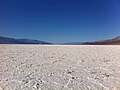 Death Valley national park, a popular tourist attraction in the Mojave Desert
 -
 An image of Joshua Tree National park, a popular tourist attraction in the Mojave Desert
 -
 A field of California poppies in the California Poppy Reserve in Antelope Valley

_--_2012_--_5690.jpg)

Flora
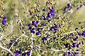
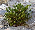
The flora of the Mojave desert are helpful in determining the extents of the Mojave desert where there may not be distinctive geophysical boundaries,[7] the Mojave desert consists of various endemic plant species, notably the Joshua Tree, which is a particularly notable endemic and indicator species of the desert. There are more endemic flora of the Mojave desert than almost anywhere in the world.[7] Mojave Desert flora is not a vegetation type, although the plants in the area have evolved in isolation because of the physical barriers of the Sierra Nevadas and the Colorado Plateau. Predominant plants of the Mojave desert include all-scale (Atriplex polycarpa), creosote bush (Larrea tridentata), brittlebush (Encelia farinosa), desert holly (Atriplex hymenelytra), white burrobush (Hymenoclea salsola), and most notably, the Joshua tree (Yucca brevifolia). Additionally, the Mojave desert is also home to various species of cacti, such as silver cholla (Cylindropuntia echinocarpa), Mojave prickly pear (O. erinacea), beavertail cactus (O. basilaris), and many-headed barrel cactus (Echinocactus polycephalus). Less common but distinctive plants of the Mojave desert include ironwood (Olneya tesota), blue Palo Verde (Parkinsonia Florida), chuparosa (Justicia californica), spiny menodora (Menodora spinescens), desert senna (Cassia armata), California dalea (Psorothamnus arborescens), and goldenhead (Acamptopappus shockleyi). The Mojave desert is generally abundant in winter annuals.[10]: 11 The plants of the Mojave desert each generally correspond to an individual geographic feature. As such, there are distinctive flora communities within the desert.
-
 A depiction of cassia armata, which is particularly characteristic of the Mojave
 -
 California Dalea, an indicator species of the Mojave Desert
 -
 Goldenhead (Acamptopappus shockleyi) an indicator species of the Mojave
 -
 Silver cholla (Opuntia echinocarpa), a common species of cacti in the Mojave
 -
 A creosote bush, which is common in the Mojave

_(16768840710).jpg)


.jpg)
Fauna
A good portion of the fauna of the Mojave Desert extends into the neighboring Sonoran and Great Basin deserts. The animal species of the Mojave Desert have generally less endemics than its flora. However, endemic fauna of the Mojave Desert include Kelso Dunes jerusalem cricket (Ammopelmatus kelsoensis), the Kelso Dunes shieldback katydid (Eremopedes kelsoensis), the Mohave ground squirrel (Spermophilus Mohavensis) and Amargosa vole (Microtus californicus scirpensis).[21] The Mojave fringe-toed lizard (Uma Scoparia) is not endemic, but almost completely limited to the Mojave desert. Notable species of the Mojave desert include the desert tortoise (Gopherus agassizii), which has adapted considerably to the conditions of the Mojave Desert and deserts in general.[7] Various other species are particularly common in the Mojave Desert, such as the LeConte's thrasher (Toxostoma lecontei), banded gecko (Coleonyx variegatus), desert iguana (Dipsosaurus dorsalis), chuckwalla (Sauromalus obesus), and regal horned lizard (Phrynosoma solare). Species of snake include the rosy boa (Lichanura trivirgata), Western patch-nosed snake (Salvadora hexalepis), and Mojave rattlesnake (Crotalus scutulatus).
_-_Flickr_-_smashtonlee05.jpg)
Protected areas and parks
Various habitats and regions of the Mojave Desert have been protected by statute. Notably, Joshua Tree National Park, Death Valley National Park, and the Mojave National Preserve by the California Desert Protection Act of 1994. (Pub.L. 103–433). Various other national parks and state parks have regions within the Mojave Desert. These include Antelope Valley California Poppy Reserve, which protects the fields of California poppies, Desert Tortoise Natural Area, Arthur B. Ripley Desert Woodland State Park, Desert National Wildlife Refuge, Lake Mead National Recreation Area, Providence Mountains State Recreation Area, Red Cliffs National Conservation Area, Red Rock Canyon State Park, Saddleback Butte State Park, Snow Canyon State Park and Valley of Fire State Park.
2009 litigation
In 2009, U.S. District Judge Susan Illston ruled against the Bureau's proposed designation of additional off-road vehicle use allowance in the western Mojave Desert. According to the ruling, the Bureau of Land Management violated its own regulations when it designated approximately 5,000 miles (8,000 km) of off-roading routes in 2006. According to Judge Illston, the Bureau's designation was significantly "flawed because it does not contain a reasonable range of alternatives" to limit damage to sensitive habitat. Judge Illston found the bureau had inadequately analyzed the routes' impacts on air quality, soils, plant communities, riparian habitats, and sensitive species such as the endangered Mojave fringe-toed lizard, pointing out that the desert and its resources are "extremely fragile, easily scarred, and slowly healed."[22]
Cities and regions


While the Mojave Desert itself is generally sparsely populated, it has increasingly become urbanized in recent years.[8][7] The metropolitan areas include Las Vegas, the largest urban area in the Mojave and the largest urban area in Nevada with a population of about 2.3 million.[23] St. George, Utah, is the northeasternmost metropolitan area in the Mojave, with a population of around 180,000 in 2020, and is located at the convergence of the Mojave, Great Basin and Colorado Plateau. The Los Angeles exurban area of Lancaster-Palmdale has more than 400,000 residents, and the Victorville area to its east has more than 300,000 residents.[8] Smaller cities or micropolitan areas in the Mojave Desert include Helendale, Lake Havasu City, Kingman, Laughlin, Bullhead City and Pahrump. All have experienced rapid population growth since 1990. The California portion of the desert also contains Edwards Air Force Base and Naval Air Weapons Station China Lake, noted for experimental aviation and weapons projects.
The Mojave Desert has several ghost towns; the most significant are the gold-mining town of Oatman, Arizona, the silver and copper-mining town of Calico, California, and the old railroad depot of Kelso, California. Some of the other ghost towns are more modern, created when U.S. Route 66 (and the lesser-known U.S. Route 91) were abandoned in favor of the construction of Interstates.
References
- ^ Munro, P., et al. A Mojave Dictionary. Los Angeles: UCLA, 1992
- ^ "Mojave desert | Ecoregions | WWF". World Wildlife Fund. Retrieved November 20, 2020.
- ^ Jones, Daniel (2003) [1917], Peter Roach; James Hartmann; Jane Setter (eds.), English Pronouncing Dictionary, Cambridge: Cambridge University Press, ISBN 978-3-12-539683-8
- ^ "Mojave". Dictionary.com Unabridged (Online). n.d.
- ^ "Mojave". Oxford English Dictionary (Online ed.). Oxford University Press. (Subscription or participating institution membership required.)
- ^ "The Mojave Desert". Blue Planet Biomes.
{{cite web}}: CS1 maint: url-status (link) - ^ a b c d e f g h i j k l m "Mojave Desert". World Wildlife Fund.
{{cite web}}: CS1 maint: url-status (link) - ^ a b c d e "Mojave Desert". Encyclopedia Britannica. March 25, 2021. Retrieved July 22, 2021.
- ^ "Mojave Desert Biome". Blue Planet Biomes. Retrieved July 23, 2021.
{{cite web}}: CS1 maint: url-status (link) - ^ a b c d e f g Rundel, Philip W; Gibson, Arthur C (2005). Ecological communities and processes in a Mojave Desert ecosystem. Cambridge University Press.
- ^ a b c d e f g Dibledee, TW Jr (1967). "Areal geology of the western Mojave Desert, California". p. 115-116,124. Professional Paper 522.
- ^ "American Indian History".
- ^ Wheat, Frank (1999). California Desert Miracle. San Diego: Sunbelt Publications. ISBN 0-932653-27-8.
- ^ "Mojave Desert". Nature. Retrieved July 24, 2021.
{{cite web}}: CS1 maint: url-status (link) - ^ a b c d Dibblee, Thomas W. "Areal geology of the western Mojave Desert, California." (1967).
- ^ "Weather - Mojave National Park Reserve". National Park Service.
{{cite web}}: CS1 maint: url-status (link) - ^ Brooks, Matthew L., and J. R. Matchett. "Spatial and temporal patterns of wildfires in the Mojave Desert, 1980–2004." Journal of Arid Environments 67 (2006): 148-164.
- ^ NOAA. "1981–2010 US Climate Normals". NOAA. Retrieved July 25, 2011.
- ^ "Seasonal Temperature and Precipitation Information". Western Regional Climate Center. Retrieved March 24, 2013.
- ^ "Seasonal Temperature and Precipitation Information". Western Regional Climate Center. Retrieved March 29, 2013.
- ^ Neuwald, JL (2010). "Population isolation exacerbates conservation genetic concerns in the endangered Amargosa vole, Microtus californicus scirpensis". Biological Conservation. 143: 2028–2038.
- ^ "Off-road Routes in Mojave Desert Found Illegal". wilderness.org. Archived from the original on April 15, 2012. Retrieved October 9, 2009.
- ^ "Las Vegas City, Nevada". United States Census Bureau. Retrieved July 24, 2021.
{{cite web}}: CS1 maint: url-status (link)
External links
 Media from Commons
 Travel information from Wikivoyage
- The Nature Explorers Mojave Desert Expedition - 1 hour 27 minute ecosystem video in July
- Mojave Desert images at bioimages.vanderbilt.edu
- Mojave Desert Blog
- Mojave Desert Catalog Project
| International | |
|---|---|
| National | |
| Geographic | |
| Other | |
- Mojave Desert
- Deserts and xeric shrublands in the United States
- Ecoregions of California
- Ecoregions of the United States
- Natural history of the Mojave Desert
- Deserts of California
- Deserts of Arizona
- Deserts of Nevada
- Deserts of Utah
- Deserts of the Lower Colorado River Valley
- Deserts of North America
- Geography of Clark County, Nevada
- Geography of Inyo County, California
- Geography of Kern County, California
- Geography of Lincoln County, Nevada
- Geography of Los Angeles County, California
- Geography of Mohave County, Arizona
- Geography of Nye County, Nevada
- Geography of San Bernardino County, California
- Geography of Washington County, Utah
- Geography of Southern California
- Southwestern United States