
190th Street station
190th Street | |||||||
|---|---|---|---|---|---|---|---|
 Uptown platform | |||||||
| Station statistics | |||||||
| Address | West 190th Street & Fort Washington Avenue New York, NY 10040 | ||||||
| Borough | Manhattan | ||||||
| Locale | Washington Heights, Hudson Heights | ||||||
| Coordinates | 40°51′32″N 73°56′03″W / 40.858986°N 73.93404°W | ||||||
| Division | B (IND)[1] | ||||||
| Line | IND Eighth Avenue Line | ||||||
| Services | A | ||||||
| Transit | |||||||
| Structure | Underground | ||||||
| Depth | 140 feet (43 m)[2] | ||||||
| Platforms | 2 side platforms | ||||||
| Tracks | 2 | ||||||
| Other information | |||||||
| Opened | September 10, 1932[3] | ||||||
| Accessible | |||||||
| Opposite- direction transfer | Yes | ||||||
| Former/other names | 190th Street – Overlook Terrace | ||||||
| Other entrances/ exits | east side of Fort Washington Avenue, west side of Bennett Avenue | ||||||
| Traffic | |||||||
| 2023 | 951,786[4] | ||||||
| Rank | 301 out of 423[4] | ||||||
| Station succession | |||||||
| Next north | Template:NYCS next | ||||||
| Next south | Template:NYCS next | ||||||
| |||||||
| |||||||
| |||||||
190th Street Subway Station (IND) (190th Street-Overlook Terrace Subway Station) | |||||||
 Ft. Washington Ave. entrance building (2014) | |||||||
| MPS | New York City Subway System MPS | ||||||
| NRHP reference No. | 05000225[5] | ||||||
| Added to NRHP | March 30, 2005 | ||||||


190th Street (originally 190th Street – Overlook Terrace) is a station on the IND Eighth Avenue Line of the New York City Subway, served by the A train at all times. It is located on Fort Washington Avenue near its intersection with Cabrini Boulevard at Margaret Corbin Circle, about 3 blocks north of 190th Street.
The station is close to Fort Tryon Park and the Mother Cabrini Shrine in the Hudson Heights neighborhood of Manhattan's Washington Heights area. The Cloisters medieval art museum, a branch of the Metropolitan Museum of Art, is located in the park, about a 10-minute walk north from the station's Fort Washington Avenue exit. An additional exit through the side of the hill leads to Bennett Avenue and provides access to the Broadway Valley area of Washington Heights.
Station layout
Track layout | |||||||||||||||||||||||||||||||||||||||||||||||||||||||||||||||
|---|---|---|---|---|---|---|---|---|---|---|---|---|---|---|---|---|---|---|---|---|---|---|---|---|---|---|---|---|---|---|---|---|---|---|---|---|---|---|---|---|---|---|---|---|---|---|---|---|---|---|---|---|---|---|---|---|---|---|---|---|---|---|---|
| |||||||||||||||||||||||||||||||||||||||||||||||||||||||||||||||
| G | Street Level | Exit/Entrance Bank of elevators in southern exit. Note: Platforms and street level are not accessible |
| M | Mezzanine | Fare control, station agent, MetroCard vending machines, tunnel to Bennett Avenue |
| P Platform level |
Side platform, doors will open on the right | |
| Northbound | ← | |
| Southbound | → | |
| Side platform, doors will open on the right | ||


The station has two tracks and two side platforms. It is the third-to-last station on the IND Eighth Avenue Line proceeding northbound.[7] The station boasts platforms 660 feet (200 m) in length—a typical length of station platforms in the Independent Subway System—and 50 feet (15 m) in width.[8] The station has a double-barrel, vaulted ceiling supported by an arcade in the center. Concrete retaining walls also side the station and fit into the structure.[8] The 207th Street-bound platform contains an exit-only (one turnstile and one gate) ramp that bypasses fare control and leads to the passageway to the Bennett Avenue entrance.
Located 140 feet (43 m) below ground level, it is one of the deepest stations in the entire system by distance to ground level; it is even deeper than the 34th Street – Hudson Yards station, the deepest station in the system by elevation below sea level.[2] (By comparison, 34th Street – Hudson Yards is only 110 feet (34 m) below the surface, which is about 15 to 20 feet (4.6 to 6.1 m) above sea level.[9]) Despite the fact that this is an extremely deep station, however, the Bennett Avenue entrance is actually at a lower elevation than the platforms, so the ramp slopes down. Additionally, Dyckman Street, the next station north, is only one level below the surface, in contrast to the 190th Street station.
The station maintains three elevators from the mezzanine in one tower at its eastern end, and has done so since its opening. There is access from Bennett Avenue via a tunnel.[8] The elevators were formerly only open during the daytime, and required the payment of a fare to use since the fare control for both street entrances to the station was originally located just inside the street doors.[10] Since 1957, the elevators have been available for use by pedestrians going between Bennett Avenue and Fort Washington Avenue without paying a fare; a similar situation exists at 181st Street, the next station downtown,[11] as well as at 191st Street, on the IRT Broadway – Seventh Avenue Line.[12] The elevators to the platforms still utilize elevator operators, one of the few stations in the system to do so.[13] The station is not wheelchair accessible (non-ADA-compliant) because access from the fare control area to the platforms is only possible via stairways. The nearest accessible stations are 175th Street, two stops south, and 207th Street, two stops north.[14]
Exits
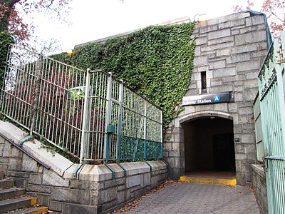
The building for the entrance on Fort Washington Avenue was originally a plain brick one, but it was later given a stone facade to harmonize it with the entrance to Fort Tryon Park, which lies directly across Margaret Corbin Circle.[15] Fare control is located in one central location on the lower mezzanine level. The elevators are available for use at no charge for pedestrians going between Hudson Heights, on top of the ridge, to the Broadway valley of Washington Heights at the bottom.[15]
- Exit at southeast corner of Fort Washington Avenue and Margaret Corbin Drive, consisting of elevators to the mezzanine[16]
- Exit at Bennett Avenue midblock between Broadway and 192nd Street, on the west side of Bennett Avenue, consisting of a passageway to the mezzanine[16]
History
Construction for a station at 190th Street began in 1928 by the New York City Board of Transportation as part of a subway expansion. Squire J. Vickers, the chief architect of the Dual System, helped design the 190th Street station. He was responsible for most stations on the IND, and being a painter, he did tile work for the station.[8] Station construction was completed in 1932 along with all the other stations on the line between Inwood–207th Street and Chambers Street–Hudson Terminal, and service began on September 10, 1932.[3][17]
In 1951, researchers from New York University concluded that in the case of a nuclear attack, the 190th Street station was sufficiently safe enough to shelter from fallout. This was ascertained after the researchers conducted tests on cosmic rays inside deep subway stations in the area.[18]
On March 30, 2005, the station was listed on the National Register of Historic Places.[19]
Gallery
-
 Fort Washington Avenue entrance
 -
 Stairs to Fort Washington Avenue entrance
 -
 Bennett Avenue entrance
 -
 Tunnel to fare control from Bennett Avenue


References
Notes
- ^ "Glossary". Second Avenue Subway Supplemental Draft Environmental Impact Statement (SDEIS) (PDF). Vol. 1. Metropolitan Transportation Authority. March 4, 2003. pp. 1–2. Archived from the original (PDF) on February 26, 2021. Retrieved January 1, 2021.
- ^ a b "The Deepest and Highest Subway Stations in NYC: 191st St, 190th Street, Smith & 9th" on Untapped Cities (June 26, 2013)
- ^ a b "List of the 28 Stations on the New Eighth Ave Line". The New York Times. New York, New York. September 10, 1932. p. 6.
- ^ a b "Annual Subway Ridership (2018–2023)". Metropolitan Transportation Authority. 2023. Retrieved April 20, 2024.
- ^ "NPS Focus". National Register of Historic Places. National Park Service. Retrieved November 6, 2011.
- ^ "Annual Subway Ridership (2018–2023)". Metropolitan Transportation Authority. 2023. Retrieved April 20, 2024.
- ^ "A Subway Timetable, Effective June 26, 2022". Metropolitan Transportation Authority. Retrieved August 26, 2023.
- ^ a b c d Steven Bedford; Stacey Vairo (2004). "NRHP Nomination: 190th Street Subway Station (IND)". National Register of Historic Places. Hartford, Connecticut: National Park Service. Retrieved 21 April 2012.
- ^ Flegenheimer, Matt (May 29, 2014). "With New Slant on Subway Elevators, Expect Delays". The New York Times. Retrieved May 29, 2014.
- ^ "Free Elevators in Subway Fought". The New York Times. August 7, 1939. p. 13. Retrieved July 29, 2016.
- ^ "2 IND Elevators Open to Free Use". The New York Times. September 6, 1957. p. 19. Retrieved 2016-07-30.
- ^ Kurtz, Josh (1991-08-12). "Washington Heights Journal; A Subway Passageway Just for the Courageous". The New York Times. ISSN 0362-4331. Retrieved 2016-07-30.
- ^ Grynbaum, Michael M. (April 28, 2011). "The Subway's Elevator Operators, a Reassuring Amenity of Another Era". The New York Times.
- ^ "Accessible Stations in the MTA Network". Metropolitan Transportation Authority. Retrieved March 8, 2010.
- ^ a b Guided tour, Fort Tryon Park Cottage (October 11, 2014)
- ^ a b "MTA Neighborhood Maps: Washington Heights" (PDF). Metropolitan Transportation Authority. 2015. Retrieved 29 July 2016.
- ^ Crowell, Paul (September 10, 1932). "Gay Midnight Crowd Rides First Trains In The New Subway: Throngs at Station an Hour Before Time, Rush Turnstiles When Chains are Dropped". New York Times. Retrieved 8 November 2015.
- ^ "190th St. Station Held Bomb-Proof – Tests Reveal Eighth Avenue Subway Stop Would Make an Ideal Raid Shelter". The New York Times. 1951-12-16. p. 65. ISSN 0362-4331. Retrieved 2016-07-30.
- ^ New York County Listings at the National Register of Historic Places (Structure - #05000225)
External links
- nycsubway.org – IND 8th Avenue: 190th Street/Overlook Terrace
- Station Reporter — A Lefferts
- Station Reporter — A Rockaway
- A Saturday walk through Washington Heights
- Fort Washington Avenue entrance from Google Maps Street View
- Bennett Avenue entrance from Google Maps Street View
- Platform from Google Maps Street View
| Eighth Ave. Line |
|
|---|---|
| |
| Topics |  | |
|---|---|---|
| Lists by county |
| |
| Lists by city | ||
| Other lists | ||
- IND Eighth Avenue Line stations
- Washington Heights, Manhattan
- Railway and subway stations on the National Register of Historic Places in Manhattan
- New York City Subway stations in Manhattan
- New York City Subway stations located underground
- Railway stations opened in 1932
- 1932 establishments in New York (state)