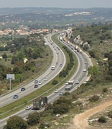
A55 autoroute
Appearance
Route map:


The A55 autoroute is a free motorway in southern France. It is 36.7 kilometres (22.8 mi) long.
The road starts at Marseille at La Joliette and ends to the west of Martigues where it becomes the N568 towards Arles and Nîmes.
Exit list
This article contains a bulleted list or table of intersections which should be presented in a properly formatted junction table. (December 2021) |
 01 (Vieux-Port) Towns served: Vieux-Port
 02 (Port) Towns served: Port with regular Ferry services to Corsica and Algeria
 03 Exchange A55-A557 Junction with the A557 to the A7 and Aix-en-Provence
 04 (La Madrague) La Madrague
 05 (L'Estaque/Le Rove) Towns served: L'Estaque, Le Rove
 06 (L'Estaque-Nord) Towns served: L'Estaque, Saint-Antoine
 Junction A7-A55 Junction with the A7
 07 (Marignan) Towns served: Marignane, Gignac-la-Nerthe, Le Rove
 08 (Ensuès-la-Redonne) Towns served: Ensuès-la-Redonne, Carry-le-Rouet, Sausset-les-Pins
 09 (La Mède-Est) Towns served: La Mède, Châteauneuf-les-Martigues
 10 (La Mède-Est) Towns served: La Mède
 11 (Martigues-Est) Towns served: Martigues
 12 (Martigues-Sus) Towns served: Martigues, Lavéra
 13 (Martiques) Towns served: Martigues D5 towards Saint-Mitre-les-Remparts and Istres
 End of autoroute which merges into the N568 towards Arles, Nîmes and Montpellier.
History
The first section was opened in 1972. The last section was completed connecting this junction to the Vieux-Port of Marseille in 1989.
Future
This motorway will be extended towards Arles by upgrading the N568 over the Plaine de la Crau. No date has been scheduled as yet, only a by-pass for Port-de-Bouc which is currently being evaluated.
External links
KML is from Wikidata

