City Railway Colony
Appearance
City Railway Colony
سٹی ریلوے کالونی | |
|---|---|
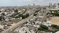
 View over the City Railway Colony | |
 | |
| Coordinates: 24°50′51″N 67°00′44″E / 24.847438°N 67.012344°E | |
| Country | Pakistan |
| Province | Sindh |
| City District | Karachi South |
| Time zone | UTC+5 (PKT) |
City Railway Colony (Template:Lang-ur) is a neighbourhood in Saddar Town[1] in Karachi, Pakistan and is part of the administrative district Karachi South.
The colony is comprising the entire area south of the Karachi City Station and the I. I. Chundrigar Road between the Railway Street with the MagnifiScience Centre is in the west and the Jinnah Courts and PIDC Bridge on the east. The KPT container terminal and the Moulvi Tamizuddin Khan Road builds the southern border.
There are several ethnic groups including Muhajirs, Sindhis, Punjabis, Kashmiris, Seraikis, Pakhtuns, Balochis, Memons, Bohras Ismailis.
Main areas
- Bottle Ghali
- New Challi
- Pakistan Chowk
- Serai Quarters
- Gate No.10
- N.T.R. colony
- Gharibabad
References
- ^ Saddar Town - Government of Karachi Archived 2006-06-13 at the Wayback Machine
External links
