
Finistère
You can help expand this article with text translated from the corresponding article in French. (February 2010) Click [show] for important translation instructions.
|
This article needs additional citations for verification. (February 2010) |
Finistère
Penn-ar-Bed (Breton) | |
|---|---|
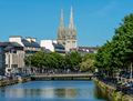
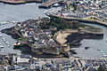
.JPG) Prefecture building of the Finistère department, in Quimper | |
 Flag  Coat of arms | |
 Location of Finistère in France | |
| Coordinates: 48°15′N 04°00′W / 48.250°N 4.000°W | |
| Country | France |
| Region | Brittany |
| Prefecture | Quimper |
| Subprefectures | Brest Châteaulin Morlaix |
| Government | |
| • President of the Departmental Council | Maël de Calan[1] (DVD) |
| Area | |
| • Total | 6,733 km2 (2,600 sq mi) |
| Population (2021)[2] | |
| • Total | 921,638 |
| • Rank | 24th |
| • Density | 140/km2 (350/sq mi) |
| Time zone | UTC+1 (CET) |
| • Summer (DST) | UTC+2 (CEST) |
| ISO 3166 code | FR-29 |
| Department number | 29 |
| Largest city | Brest |
| Arrondissements | 4 |
| Cantons | 27 |
| Communes | 277 |
| ^1 French Land Register data, which exclude estuaries, and lakes, ponds, and glaciers larger than 1 km2 | |
Finistère (/ˌfɪnɪˈstɛər/, French: [finistɛʁ] ⓘ; Breton: Penn-ar-Bed [ˌpɛnarˈbeːt]) is a department of France in the extreme west of Brittany. Its prefecture is Quimper and its largest city is Brest. In 2019, it had a population of 915,090.[3]
History[edit]

The present department consists of the historical region of Léon and parts of Cornouaille and Trégor, both parts of pre-revolutionary Brittany.
The name Finistère derives from the Latin Finis Terræ, meaning end of the earth. In England, a similar area is called Land's End. The Breton name for Finistère, Penn ar Bed, translates as "Head/End of the World" and is similar to the Cornish name for Land's End, Pedn-an-Wlas (Head/End of the country), and also Penfro (English: Pembroke) in Wales (pen = end, bro = country). Finistère is not to be confused with Fisterra in Galicia, Spain, which shares the same etymology.
Geography[edit]
The largest population centre in Finistère is Brest. Other large towns in the department include Quimper (the capital), Concarneau, Morlaix, Carhaix, Quimperlé and Douarnenez. Finistère includes the island of Ushant (Eusa in Breton, Ouessant in French).
Finistère is the westernmost department of Metropolitan France and can also claim to be the "most coastal" department in Metropolitan France. Of its 277 communes, 117 are located on the coast. Its total coastline of approximately 1,250 km (776.71 mi) accounts for almost a quarter of the entire Brittany coast-line.

The abers, rugged fjord-like inlets on the north coast, are a notable feature of the landscape.
The westernmost point of continental France, known as the Pointe de Corsen, extends from the northwestern tip of Finistère. About 40 kilometres to the south (as the crow flies) is the slightly less westerly, but rugged and isolated, headland of Pointe du Raz.
Principal towns[edit]
The most populous commune is Brest; the prefecture Quimper is the second-most populous. As of 2019, there are 5 communes with more than 15,000 inhabitants:[3]
| Commune | Population (2019) |
|---|---|
| Brest | 139,926 |
| Quimper | 63,283 |
| Concarneau | 19,816 |
| Landerneau | 15,918 |
| Guipavas | 15,050 |
Demographics[edit]
|
| |||||||||||||||||||||||||||||||||||||||||||||||||||||||||||||||||||||||||||
| ||||||||||||||||||||||||||||||||||||||||||||||||||||||||||||||||||||||||||||
| source:[4][5] | ||||||||||||||||||||||||||||||||||||||||||||||||||||||||||||||||||||||||||||
Economy[edit]
Agriculture, food processing and various related industries occupy an important place in Finistère's economy.
The military presence in Finistère (Île Longue nuclear submarine base and the Naval Air base of Lanvéoc-Poulmic), as well as military-related industries, such as the Brest headquarters of DCNS, employ a significant number of the département's population.
The port of Roscoff links Brittany by ferry with Ireland and Great Britain.
Politics[edit]
Current National Assembly Representatives[edit]
Culture[edit]
Finistère is the area where Breton survives most strongly as a spoken language. Breton-speaking schools are called Diwan, Divyezh and Dihun.
The Festival de Cornouaille, which takes place in Quimper, is a celebration of Breton music and traditions. One of the highlights of summer in Finistère is the "Festival des Vieilles Charrues" held in Carhaix-Plouguer. Major international stars attract tens of thousands of spectators.[7]
The painter Raymond Wintz (1884–1956) featured many locations around Finistère.
Roland Doré was a sculptor who executed many of the calvaries in Finistère.
Tourism[edit]
-
-
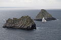
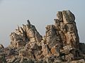 Granite rocks in Ouessant
 -
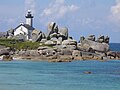 Pontusval lighthouse near Brignogan-Plages
 -

-
-
-
 Pointe du Chateau, Plougrescant
 -


.jpg)
See also[edit]
- Cantons of the Finistère department
- Communes of the Finistère department
- Arrondissements of the Finistère department
- Ys
- Calvary at Saint-Herbot near Plonévez-du-Faou and the Chapelle Saint-Herbot.
- Notre Dame de Roscudon Church
References[edit]
- ^ "Répertoire national des élus: les conseillers départementaux". data.gouv.fr, Plateforme ouverte des données publiques françaises (in French). 4 May 2022.
- ^ "Téléchargement du fichier d'ensemble des populations légales en 2021". The National Institute of Statistics and Economic Studies. 28 December 2023.
- ^ a b Populations légales 2019: 29 Finistère, INSEE
- ^ "Historique du Finistère". Le SPLAF.
- ^ "Évolution et structure de la population en 2016". INSEE.
- ^ "Assemblée nationale ~ les députés, le vote de la loi, le Parlement français". Archived from the original on 2006-03-18. Retrieved 2018-12-13.
- ^ "Vieilles Charrues Festival" Archived 2011-02-03 at the Wayback Machine, official website
External links[edit]
- (in French) Departmental Council website
- (in French) Prefecture website
- (in English) Finistere at Curlie
- (in French) Finistère Tourisme, agence de développement touristique du Finistère
| International | |
|---|---|
| National | |
| Geographic | |
| Other | |