
Khtzkonk Monastery
| Khtzkonk monastery | |
|---|---|
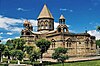
 Khtzkonk in the early 20th century | |
| Religion | |
| Affiliation | Armenian Apostolic Church |
| Ecclesiastical or organizational status | Monastery |
| Status | Abandoned after 1920, partially destroyed by Turkish Army in the 1950s |
| Location | |
| Location | Digor district |
 Shown within Turkey | |
| Geographic coordinates | 40°22′50″N 43°22′35″E / 40.380556°N 43.376389°E |
| Architecture | |
| Style | Armenian |
| Groundbreaking | Seventh century |
| Completed | Thirteenth century |
Khtzkonk Monastery (Armenian: Խծկոնք, also transcribed as Xc'konk'; Turkish: Beşkilise) was a monastic ensemble of five Armenian churches built between the seventh and thirteenth centuries in what was then the Armenian Bagratid kingdom.[1] It is now near the town of Digor, the administrative capital of the Digor district of the Kars Province in Turkey, about 19 kilometres west of the border with Armenia. The monastery is located in a gorge formed by the Digor River.
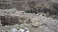
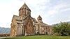
The monastery with its five churches was intact when photographed by the Armenian archaeologist Ashkharbek Kalantar in August 1920, just before Turkey captured the region from Armenia.[2] In 1959 the French art historian Jean-Michel Thierry visited the site and found that four of the five churches had been destroyed, with only the Church of Saint Sargis surviving.[3] According to local people, the churches were blown up by the Turkish army using high explosives, which was reaffirmed by citizens of Digor in 2002.[4] Their information is confirmed by the physical evidence on the site. The dome of the surviving church is intact but the side walls have been blown outwards; the destroyed churches have been entirely leveled with their masonry blasted into the gorge below. This is damage that cannot have occurred as a result of an earthquake, William Dalrymple remarked.[5]
Gallery
-
 Khtzkonk, as seen in 1920.
 -
 Khtzkonk, as seen in the early 20th century.
 -
 Khtzkonk today.
 -
 Walls of the church of Saint Sargis
 -
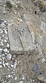
 Inscription
 -
 Interior walls
 -
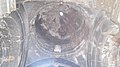 The dome
 -
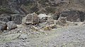
 Desecrated graveyard above monastery
 -
 Gravestone
 -
 Remains of church of Saint Gregory


Notes
- ^ Sinclair, Thomas A. (1987), Eastern Turkey: An Architectural and Archaeological Survey, Volume 1. London: Pindar Press, p. 421.
- ^ Kalantar, Ashkharbek (1994), Armenia From the Stone Age to the Middle Ages, Selected Papers, Neuchâtel: Recherches et Publications, pp. 84-89.
- ^ (in French) Thierry, Jean-Michel, "Notes Sur des Monuments Armeniens en Turquie (1964)," Revue des Études Arméniennes 2 (1965), 165-84.
- ^ Hofmann, Tessa (2003). Armenians in Turkey Today: A Critical Assessment of the Situation of the Armenian Minority in the Turkish Republic. Brussels: Forum of Armenian Associations of Europe, p. 40.
- ^ Dalrymple, William , "Armenia's Other Tragedy," The Independent Magazine, 18 March 1989.
External links
- The Monastery օf Khtzkonk on VirtualAni.org
- Gagik Arzumanyan's photo gallery
- Image gallery of Khtzkonk at Research on Armenian Architecture's website
- Images from 1968[permanent dead link] at the Gateway to Armenian Cultural Heritage website


- Armenian churches in Turkey
- Christian monasteries established in the 7th century
- Oriental Orthodox congregations established in the 7th century
- Buildings and structures demolished in the 1950s
- Destroyed churches in Turkey
- Demolished buildings and structures in Turkey
- Churches destroyed by Muslims
- Armenian buildings in Turkey
- 7th-century churches in Turkey