
Lerwick
Lerwick
| |
|---|---|
 | |
| Population | 7,500 [1] |
| OS grid reference | HU474414 |
| • Edinburgh | 300 miles |
| • London | 600 miles |
| Council area | |
| Lieutenancy area | |
| Country | Scotland |
| Sovereign state | United Kingdom |
| Post town | SHETLAND |
| Postcode district | ZE1 |
| Dialling code | 01595 |
| Police | Scotland |
| Fire | Scottish |
| Ambulance | Scottish |
| UK Parliament | |
| Scottish Parliament | |
| Website | http://www.shetland.org |
Lerwick is the capital and main port of the Shetland Islands, Scotland, located more than 100 miles (160 km) off the north coast of mainland Scotland on the east coast of the Shetland Mainland. Lerwick is about 210 miles (340 km) north of Aberdeen, 230 miles (370 km) west of Bergen in Norway and 230 miles (370 km) south east of Tórshavn in the Faroe Islands.
Lerwick, Shetland's only burgh, had a population of about 7,500 residents in 2010[1] and is the most northerly and most easterly town in Scotland (there are other large settlements more northerly in Shetland, most notable the village of Brae).
One of the UK's coastal weather stations is located at Lerwick.
History
Lerwick is a name with roots in Old Norse and its local descendant, Norn, which was spoken in Shetland until the mid-19th century. The name "Lerwick" means bay of clay. The corresponding Norwegian name is Leirvik, leir meaning clay and vik meaning "bay" or "inlet". Towns with similar names exist in south western Norway (Leirvik) and on the Faroe Islands as well.
Evidence of human settlement in the Lerwick area dates back 3,000 years, centred around the Broch of Clickimin, which was constructed in the first century BC.
The first settlement to be known as Lerwick was founded in the 17th century as a herring and white fish seaport to trade with the Dutch fishing fleet. This settlement was on the mainland (west) side of Bressay Sound, a natural harbour with south and north entrances between the Shetland mainland and the island of Bressay.
This collection of wooden huts was burned to the ground twice: once in the 17th century by the residents of Scalloway, then the capital of Shetland, who disapproved of the immoral and drunken activities of the assembled fishermen and sailors; and again in 1702 by the French fleet.
Fort Charlotte was built in the mid 17th Century on Lerwick’s waterfront, and permanent stone-built buildings began to be erected around the fort and along the shoreline. The principal concentration of buildings was in the "lanes" area: a steep hillside stretching from the shoreline to Hillhead at the top.
Lerwick became capital of Shetland Islands in 1708. When Lerwick became more prosperous through sea trade and the fishing industry during the 19th century, the town expanded to the west of Hillhead. Lerwick Town Hall was built during this period of expansion.
The next period of significant expansion was during the North Sea oil boom of the 1970s when large housing developments were built to the north of Staney Hill (located in Lerwick) and to the south (Nederdale and Sandveien).
Climate
Lerwick has an oceanic climate like the rest of the British Isles though bordering with a subpolar oceanic climate (Cfc) with cool to cold temperatures all year long. This is particularly pronounced by virtue of Lerwick being on a small isolated island, so even extreme temperature records are subdued; the record high stands at just 23.4 °C (74.1 °F) (July 1991) and the record low just −8.9 °C (16.0 °F) (January 1952 & 1959). Lerwick is also a very cloudy town averaging only 1065 sunshine hours annually.
| Climate data for Lerwick, 82m asl, 1971-2000, extremes 1922- | |||||||||||||
|---|---|---|---|---|---|---|---|---|---|---|---|---|---|
| Month | Jan | Feb | Mar | Apr | May | Jun | Jul | Aug | Sep | Oct | Nov | Dec | Year |
| Record high °C (°F) | 11.7 (53.1) |
11.7 (53.1) |
13.3 (55.9) |
16.1 (61.0) |
20.7 (69.3) |
23.3 (73.9) |
23.4 (74.1) |
21.5 (70.7) |
19.4 (66.9) |
17.2 (63.0) |
13.9 (57.0) |
12.2 (54.0) |
23.4 (74.1) |
| Mean daily maximum °C (°F) | 5.6 (42.1) |
5.4 (41.7) |
6.3 (43.3) |
7.7 (45.9) |
10.2 (50.4) |
12.2 (54.0) |
13.9 (57.0) |
14.2 (57.6) |
12.4 (54.3) |
10.1 (50.2) |
7.6 (45.7) |
6.2 (43.2) |
9.3 (48.8) |
| Mean daily minimum °C (°F) | 1.5 (34.7) |
1.4 (34.5) |
1.9 (35.4) |
2.9 (37.2) |
5.2 (41.4) |
7.4 (45.3) |
9.4 (48.9) |
9.8 (49.6) |
8.2 (46.8) |
6.2 (43.2) |
3.6 (38.5) |
2.0 (35.6) |
5.0 (40.9) |
| Record low °C (°F) | −8.9 (16.0) |
−7.3 (18.9) |
−8.3 (17.1) |
−5.7 (21.7) |
−2.8 (27.0) |
−0.6 (30.9) |
3.3 (37.9) |
1.7 (35.1) |
−0.6 (30.9) |
−3.3 (26.1) |
−5.7 (21.7) |
−8.3 (17.1) |
−8.9 (16.0) |
| Average precipitation mm (inches) | 135.4 (5.33) |
107.8 (4.24) |
122.3 (4.81) |
74.2 (2.92) |
53.6 (2.11) |
58.6 (2.31) |
58.5 (2.30) |
78.3 (3.08) |
115.3 (4.54) |
131.9 (5.19) |
152.4 (6.00) |
150.0 (5.91) |
1,238.3 (48.74) |
| Mean monthly sunshine hours | 22.6 | 52.3 | 85.6 | 129.9 | 168.3 | 148.2 | 120.0 | 124.6 | 100.8 | 65.4 | 33.0 | 14.9 | 1,065.6 |
| Source 1: MetOffice,[2] | |||||||||||||
| Source 2: Shetland Govt,[3] | |||||||||||||
Industry and economy
Lerwick is a busy fishing and ferry port. The harbour also services vessels supporting the offshore oil industry.
Notable buildings

Significant buildings in Lerwick include Fort Charlotte, Lerwick Town Hall, the Böd of Gremista, Shetland Museum and Archives and Clickimin Broch.
Transportation
Lerwick is served by the Tingwall Airport located a few miles away and Sumburgh Airport that is further south and flies all year to some Scotland destinations.
Northlink Ferries operate a daily overnight ferry service between Lerwick and Aberdeen, regularly calling in to Kirkwall in the Orkney Islands.
The Shetland Islands Council operate a ro-ro ferry service to Out Skerries and Bressay from a terminal in the centre of the town.
The local bus service is provided by the Regional Transport Partnership ZetTrans and operated by a number of different local bus service operators.[4]
Schools and education
Lerwick has three schools; Bell's Brae Primary School, Sound Primary School and Anderson High School.
Shetland College, a constituent partner institution of the University of the Highlands and Islands, is also based in the town, offering degree-level education (among other further education courses) to locals who may have difficulty travelling further afield to study (the next closest university-level institution is the University of Aberdeen, a twelve-hour boat journey away).
Hospitals and healthcare
The Gilbert Bain Hospital provides secondary care services to all of Shetland. The Lerwick Health Centre is situated across the South Road from the hospital.
Media
Local independent radio station SIBC broadcasts daily from a studio in Market Street. BBC Radio Shetland, a BBC Radio Scotland regional opt out, has its studios in Pitt Lane. The Shetland Times, a weekly local newspaper, has its premises in Gremista on the northern outskirts of Lerwick. Millgaet Media Group, a multi-media production company that includes Shetland Television, is based at the North Ness Business Park.
Culture
Lerwick has strong ties with Scandinavian countries, particularly Norway (Lerwick has a friendship agreement with Måløy in Norway), and this is reflected in the street names of Lerwick (e.g. King Harald Street, King Haakon Street).
Events
Lerwick is the focus of most events in Shetland, including the largest of the annual Up Helly-Aa fire festivals which takes place on the last Tuesday of January every year.
Places of worship
There are several churches in Lerwick, including:
- Adam Clarke Memorial Methodist Church (a congregation of the Methodist Church of Great Britain).
- Assemblies of God.
- Baptist Church, Clairmont Place. [1]
- Congregational Church.
- Emmanuel Christian Fellowship. [2]
- St. Columba's Church – one of three buildings of Lerwick and Bressay Parish Church (part of the Church of Scotland). [3]
- St. Magnus' Church, Greenfield Place (part of the Scottish Episcopal Church). [4]
- Eben Ezer Gospel Hall, Brethren Church
- St. Margaret's Roman Catholic Church.
Gallery
-
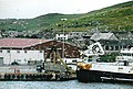 Lerwick Harbour
 -
 View of Lerwick from Bressay
 -
 Commercial Street
 -
 Lerwick Town Hall
 -
 Lerwick from Fort Charlotte


See also
- Leirvik – a town on the island of Stord in Norway
- Leirvík – a village on the island of Eysturoy, one of the Faroe Islands
References
- ^ a b "Visit.Shetland.org". Visit Shetland. Retrieved 25 December 2010.
- ^ "Climatological Information for Lerwick, United Kingdom". UKMO.
- ^ "Climatological Information for Lerwick, United Kingdom" (PDF). shetland.gov.uk.
- ^ "Shetland's Transport Partnership Website". Retrieved 27 Octobre 2011.
{{cite web}}: Check date values in:|accessdate=(help)
External links
- Shetlopedia.com – Lerwick Pages
- Listen to recordings of a speaker of Lerwick Scots
- Weir's Way visits Lerwick
- Shetland in Statistics, published by Shetland Islands Council 2006
- Bell's Brae Primary School
- Sound Primary School
- Anderson High School
- SIBC – Official Website
- Northlink Ferries – Official Website
- Smyril Line – Official Website
| Inhabited islands | ||
|---|---|---|
| Other islands | ||
| Towns and villages | ||
| Mainland Parishes | ||
| Insular Parishes | ||
| Maritime features | ||
Extreme points
| ||
| Topics | ||