
Mangaldan
Mangaldan | |
|---|---|
| Municipality of Mangaldan | |
 Street in Mangaldan | |
 Seal | |
| Anthem: Abante Mangaldan | |
 Map of Pangasinan with Mangaldan highlighted | |
OpenStreetMap  | |
.svg) Mangaldan Location within the Philippines | |
| Coordinates: 16°04′12″N 120°24′14″E / 16.07000°N 120.40389°E | |
| Country | Philippines |
| Region | Ilocos Region |
| Province | Pangasinan |
| District | 4th district |
| Founded | June 2, 1600 |
| Barangays | 30 (see Barangays) |
| Government | |
| • Type | Sangguniang Bayan |
| • Mayor | Bona Fe De Vera-Parayno |
| • Vice Mayor | Mark Stephen D.V. Mejia |
| • Representative | Christopher P. de Venecia |
| • Municipal Council | Members |
| • Electorate | 67,912 voters (2022) |
| Area | |
| • Total | 48.47 km2 (18.71 sq mi) |
| Elevation | 7.0 m (23.0 ft) |
| Highest elevation | 28 m (92 ft) |
| Lowest elevation | −3 m (−10 ft) |
| Population (2020 census)[3] | |
| • Total | 113,185 |
| • Density | 2,300/km2 (6,000/sq mi) |
| • Households | 27,502 |
| Economy | |
| • Income class | 1st municipal income class |
| • Poverty incidence | 8.98 |
| • Revenue | ₱ 334.1 million (2020) |
| • Assets | ₱ 831.7 million (2020) |
| • Expenditure | ₱ 280 million (2020) |
| • Liabilities | ₱ 136.1 million (2020) |
| Service provider | |
| • Electricity | Central Pangasinan Electric Cooperative (CENPELCO) |
| Time zone | UTC+8 (PST) |
| ZIP code | 2432 |
| PSGC | |
| IDD : area code | 48.47 |
| Native languages | Pangasinan Ilocano Tagalog |
| Website | www |
Mangaldan, officially the Municipality of Mangaldan (Pangasinan: Baley na Mangaldan; Ilocano: Ili ti Mangaldan; Tagalog: Bayan ng Mangaldan), is a 1st class municipality in the province of Pangasinan, Philippines. According to the 2020 census, it has a population of 113,185 people.[3]
History[edit]
Mangaldan owns the distinction as the third town in Pangasinan to be founded by the Dominican missionaries. As early as 1591, Mangaldan already existed as a Spanish encomienda. Its foundation as a town is attributed to Juan Martinez de Santo Domingo, a former missionary of Pangasinan who died in Japan on 19 March 1618.
Mangaldan started as a "visita" of Calasiao and it remained as such until the Dominicans created it as an independent vicariate under the patronage of St. Thomas Aquinas on 2 June 1600.
It is said that of all the people of Pangasinan, the Mangaldanian were the most difficult to convert. The greatest enemy of the missionaries in the town was a certain man named Casipit who tried to force them out of the town and even attempted to kill some of them. Yet, when he was converted by the first apostle, Fr. Pedro Soto, he became the principal propagator of the Faith. He contributed a great sum of money for the construction of the first church.
In the second half of the 19th century, Mangaldan was the richest town in the province. This was due to the famous irrigation system which the missionaries built within the confines of the town[5] causing its fertile fields to yield bountiful harvest of palay. Most outstanding in this gigantic task was Fr. Jose Torres who gave his life to bring it to completion in 1892.
The third church to be built in Mangaldan was completed in 1812 by Fr. Lorenzo Martin. It collapsed during the great earthquake of 16 March 1892, together with the big chapel in the cemetery. The construction of the convent dates back in 1747. The construction of the sixth and present church of Mangaldan was begun in 1942 by Fr. Juan Sison, and was completed 20 years later by Fr. Leon Bitanga.
During World War II, Mangaldan had an airstrip that was used by the American military.
Geography[edit]
Mangaldan is located in the central part of Pangasinan. The Municipality is bordered by San Fabian on the north, Dagupan on the west, San Jacinto on the east and on the south, the municipalities of Mapandan and Santa Barbara.
It is 219 kilometres (136 mi) from the national capital Manila and 23 kilometres (14 mi) from the provincial capital Lingayen.
Barangays[edit]
Mangaldan is politically subdivided into 30 barangays. Each barangay consists of puroks and some have sitios.
- Alitaya
- Amansabina
- Anolid
- Banaoang
- Bantayan
- Bari
- Bateng
- Buenlag
- David
- Embarcadero
- Gueguesangen
- Guesang
- Guiguilonen
- Guilig
- Inlambo
- Lanas
- Landas
- Maasin
- Macayug
- Malabago
- Navaluan
- Nibaliw
- Osiem
- Palua
- Poblacion
- Pogo
- Salaan
- Salay
- Talogtog
- Tebag
Climate[edit]
| Climate data for Mangaldan, Pangasinan | |||||||||||||
|---|---|---|---|---|---|---|---|---|---|---|---|---|---|
| Month | Jan | Feb | Mar | Apr | May | Jun | Jul | Aug | Sep | Oct | Nov | Dec | Year |
| Mean daily maximum °C (°F) | 31 (88) |
31 (88) |
33 (91) |
34 (93) |
34 (93) |
33 (91) |
32 (90) |
31 (88) |
31 (88) |
32 (90) |
31 (88) |
31 (88) |
32 (90) |
| Mean daily minimum °C (°F) | 21 (70) |
21 (70) |
23 (73) |
25 (77) |
25 (77) |
25 (77) |
25 (77) |
24 (75) |
24 (75) |
24 (75) |
23 (73) |
22 (72) |
24 (74) |
| Average precipitation mm (inches) | 4.3 (0.17) |
19.1 (0.75) |
27.3 (1.07) |
45.2 (1.78) |
153.3 (6.04) |
271.3 (10.68) |
411.1 (16.19) |
532 (20.9) |
364.4 (14.35) |
182.5 (7.19) |
56.3 (2.22) |
24.4 (0.96) |
2,091.2 (82.3) |
| Average rainy days | 3 | 2 | 3 | 5 | 14 | 17 | 22 | 23 | 21 | 13 | 7 | 4 | 134 |
| Source: World Weather Online[6] | |||||||||||||
Rivers[edit]
There are four rivers in Mangaldan: the Old Mangaldan River, the Manguiragday River, the Angalacan River and the Paldakit River.
Demographics[edit]
| Year | Pop. | ±% p.a. |
|---|---|---|
| 1903 | 15,841 | — |
| 1918 | 16,761 | +0.38% |
| 1939 | 18,997 | +0.60% |
| 1948 | 26,102 | +3.59% |
| 1960 | 33,422 | +2.08% |
| 1970 | 41,867 | +2.28% |
| 1975 | 46,230 | +2.01% |
| 1980 | 50,434 | +1.76% |
| 1990 | 65,947 | +2.72% |
| 1995 | 73,351 | +2.01% |
| 2000 | 82,142 | +2.46% |
| 2007 | 90,391 | +1.33% |
| 2010 | 98,905 | +3.33% |
| 2015 | 106,331 | +1.39% |
| 2020 | 113,185 | +1.24% |
| Source: Philippine Statistics Authority[3][7][8][9][10] | ||
Economy[edit]
Graphs are unavailable due to technical issues. There is more info on Phabricator and on MediaWiki.org. |
Mangaldan celebrates its annual Pindang Festival along with its town fiesta during first week of March. The popular carabeef tapa (Filipino-style dried meat), locally known as Pindang is the One Town One Product (OTOP) of this municipality.[18] The municipality is also the home of the original makers of the famous delicacy – the Romana Peanut Brittle.
The town bagged the grand slam award when its inland body of water, the Angalacan River, was adjudged as the cleanest river in the entire province for the third time which was awarded in 2012.[19]
One of the major sources of revenues here are the thriving market place and the laboratories of renowned pharmaceutical companies that buttressed the coffer of this town.[20] The municipal government operates its slaughterhouse with a rated "double A" by the National Meat Inspection Service (NMIS) that guarantees the butchered meat as safe and clean.
In 2015, the annual budget of Mangaldan involves a total appropriation of Php 208, 527, 497.39, which would be the biggest for a first class town in Pangasinan.[21]
Government[edit]
Local government[edit]
Mangaldan, belonging to the fourth congressional district of the province of Pangasinan, is governed by a mayor designated as its local chief executive and by a municipal council as its legislative body in accordance with the Local Government Code. The mayor, vice mayor, and the councilors are elected directly by the people through an election which is being held every three years.
Elected officials[edit]
| Position | Name |
|---|---|
| Congressman(4th Legislative District the Province of Pangasinan) | Christopher George Martin P. de Venecia |
| Mayor | Mayor Bona Fe De Vera-Parayno |
| Vice-Mayor | Vice Mayor Mark Stephen D.V. Mejia |
| Councilors | Aldrin O. Soriano |
| Fernando Juan A. Cabrera | |
| Joseph Emmanuel B. Cera | |
| Joselito D. Quinto | |
| Juvy O. Frialde | |
| Christopher G. Romero | |
| Joel C. Meneses | |
| Lovely Lian C. Maramba |
Education[edit]
Private Primary and Secondary schools[edit]
- Aura Vista Montessori and High School
- Bethel Christian Learning Center
- Cherished Moments School
- Clarice Angels School
- Golden Angels Educational Institution
- Mangaldan Achievers Academy
- Mangaldan Technical Institute
- Metro-Dagupan Colleges
- Santo Tomas Catholic School
- The Right Formation School
- United Methodist Church Cinderella School
Public Primary schools[edit]
- Mangaldan Central School
- Alitaya Elementary School
- Anolid Elementary School
- Buenlag Elementary School
- David Elementary School
- Don Gregorio I. Magno Elementary School
- Dona Felisa Navarro Elementary School
- Embarcadero Elementary School
- Gueguesangen Integrated School
- Guesang Elementary School
- Lanas Elementary School
- Maasin Elementary School
- Macayug Elementary School
- Nibaliw Elementary School
- Osiem Elementary School
- Salaan Elementary School
- Salay Elementary School
- Talogtog Elementary School
- Tebag Elementary School.
Public Secondary schools[edit]
- David National High School
- Gueguesangen Integrated School
- Mangaldan Integrated School
- Mangaldan National High School
Gallery[edit]
-
 Welcome Arch along Mangaldan-San Fabian Border
 -
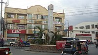
 Mangaldan Centro and Townhall
 -
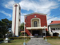 Vicariate of Santo Tomas de Aquino, Parish of St. Thomas Aquinas
 -
 Junction, crossing along N55 and N242
 -
 Mangaldan Police Station
 -
 Rizal Avenue (N55 segment)
 -
 Rizal Statue at Mangaldan Plaza
 -
 Mangaldan Public Fountain

.jpg)


.jpg)
.jpg)
.jpg)

See also[edit]
References[edit]
- ^ Municipality of Mangaldan | (DILG)
- ^ "2015 Census of Population, Report No. 3 – Population, Land Area, and Population Density" (PDF). Philippine Statistics Authority. Quezon City, Philippines. August 2016. ISSN 0117-1453. Archived (PDF) from the original on 25 May 2021. Retrieved 16 July 2021.
- ^ a b c Census of Population (2020). "Region I (Ilocos Region)". Total Population by Province, City, Municipality and Barangay. Philippine Statistics Authority. Retrieved 8 July 2021.
- ^ "PSA Releases the 2018 Municipal and City Level Poverty Estimates". Philippine Statistics Authority. 15 December 2021. Retrieved 22 January 2022.
- ^ "Capital of Pangasinan: Mangaldan Church". 18 February 2008.
- ^ "Mangaldan, Pangasinan: Average Temperatures and Rainfall". World Weather Online. Retrieved 12 October 2015.
- ^ Census of Population (2015). "Region I (Ilocos Region)". Total Population by Province, City, Municipality and Barangay. Philippine Statistics Authority. Retrieved 20 June 2016.
- ^ Census of Population and Housing (2010). "Region I (Ilocos Region)" (PDF). Total Population by Province, City, Municipality and Barangay. National Statistics Office. Retrieved 29 June 2016.
- ^ Censuses of Population (1903–2007). "Region I (Ilocos Region)". Table 1. Population Enumerated in Various Censuses by Province/Highly Urbanized City: 1903 to 2007. National Statistics Office.
{{cite encyclopedia}}: CS1 maint: numeric names: authors list (link) - ^ "Province of Pangasinan". Municipality Population Data. Local Water Utilities Administration Research Division. Retrieved 17 December 2016.
- ^ "Poverty incidence (PI):". Philippine Statistics Authority. Retrieved 28 December 2020.
- ^ "Estimation of Local Poverty in the Philippines" (PDF). Philippine Statistics Authority. 29 November 2005.
- ^ "2003 City and Municipal Level Poverty Estimates" (PDF). Philippine Statistics Authority. 23 March 2009.
- ^ "City and Municipal Level Poverty Estimates; 2006 and 2009" (PDF). Philippine Statistics Authority. 3 August 2012.
- ^ "2012 Municipal and City Level Poverty Estimates" (PDF). Philippine Statistics Authority. 31 May 2016.
- ^ "Municipal and City Level Small Area Poverty Estimates; 2009, 2012 and 2015". Philippine Statistics Authority. 10 July 2019.
- ^ "PSA Releases the 2018 Municipal and City Level Poverty Estimates". Philippine Statistics Authority. 15 December 2021. Retrieved 22 January 2022.
- ^ Viray, Marla (27 June 2011). "Family stamps own brand on 'tapa'". Philippine Daily Inquirer. Retrieved 1 June 2017.
- ^ "You are being redirected..."
- ^ "P'NAN NEWS: Mangaldan is richer than other major towns". 4 December 2011.
- ^ "DECLARING THE ANNUAL BUDGET FOR CALENDAR YEAR 2014 OF MANGALDAN, PANGASINAN INVOLVING A TOTAL APPROPRIATION OF P178,658,338.35 OPERATIVE IN ITS ENTIRETY | The Official Website of the Province of Pangasinan and its People". pangasinan.gov.ph. Retrieved 1 June 2017.
- ^ "2022 National and Local Elections". ABS-CBN News. Retrieved 6 August 2022.
External links[edit]
- Official website
- Mangaldan Profile at PhilAtlas.com
- Municipal Profile at the National Competitiveness Council of the Philippines
- Mangaldan at the Pangasinan Government Website
- Local Governance Performance Management System
- Philippine Standard Geographic Code
- Philippine Census Information
Places adjacent to Mangaldan | ||||||||||||||||
|---|---|---|---|---|---|---|---|---|---|---|---|---|---|---|---|---|
| ||||||||||||||||
| Municipalities |
|
|---|---|
| Component cities | |
| Independent component city |
|
| Barangays | |