
Netherlands Antilles
Netherlands Antilles | |||||||||||||||
|---|---|---|---|---|---|---|---|---|---|---|---|---|---|---|---|
| 1954–2010 | |||||||||||||||
| Motto: Latin: Libertate unanimus "Unified by freedom" | |||||||||||||||
| Anthem: Het Wilhelmus (1954–1964) Tera di Solo y suave biento (1964–2000) Anthem without a title (2000–2010) | |||||||||||||||
.svg) | |||||||||||||||
| Status | Former constituent country of the Kingdom of the Netherlands | ||||||||||||||
| Capital | Willemstad | ||||||||||||||
| Common languages | Dutch English Papiamento[1] | ||||||||||||||
| Demonym(s) | Netherlands Antillean | ||||||||||||||
| Government | Constitutional monarchy | ||||||||||||||
| Queen | |||||||||||||||
• 1954–1980 | Juliana | ||||||||||||||
• 1980–2010 | Beatrix | ||||||||||||||
• 1951–1956 | Teun Struycken | ||||||||||||||
• 1962–1970 | Cola Debrot | ||||||||||||||
• 1983–1990 | René Römer | ||||||||||||||
• 2002–2010 | Frits Goedgedrag | ||||||||||||||
• 1954–1968 | Efraïn Jonckheer | ||||||||||||||
• 1973–1977 | Juancho Evertsz | ||||||||||||||
• 2006–2010 | Emily de Jongh-Elhage | ||||||||||||||
| Legislature | Estates of the Netherlands Antilles | ||||||||||||||
| History | |||||||||||||||
• Established | 15 December 1954 | ||||||||||||||
• Secession of Aruba | 1 January 1986 | ||||||||||||||
| 10 October 2010 | |||||||||||||||
| Area | |||||||||||||||
| 2010 | 999 km2 (386 sq mi) | ||||||||||||||
| Population | |||||||||||||||
• 2010 | 304,759 | ||||||||||||||
| Currency | Netherlands Antillean guilder | ||||||||||||||
| Calling code | 599 | ||||||||||||||
| Internet TLD | .an | ||||||||||||||
| |||||||||||||||
.svg)
.svg)
The Netherlands Antilles (Dutch: Nederlandse Antillen [ˈneːdərˌlɑntsə ɑnˈtɪlə(n)] ⓘ, Papiamentu: Antia Hulandes[2]), also referred to informally as the Dutch Antilles,[3] was an autonomous Caribbean country within the Kingdom of the Netherlands. Although the country has now been dissolved, all of its constituent islands remain part of the kingdom under a different legal status and the term is still used to refer to these Dutch Caribbean islands.
The Netherlands Antilles consisted of two distinct island groups. The ABC Islands of Aruba, Bonaire, and Curaçao are located in the southern Caribbean Sea, just off the Venezuelan coast. The SSS islands of Sint Maarten (actually a territory covering a bit less than half an island), Saba, and Sint Eustatius are in the Leeward Islands southeast of the Virgin Islands near the northern end of the Lesser Antilles, approximately 800–900 kilometers (500–560 miles) northeast of the ABC Islands. The Dutch colonized the various islands in the 17th century and united them in the new constituent state of the Netherlands Antilles in 1954.
Aruba became a separate state within the Kingdom of the Netherlands in 1986. The Kingdom of the Netherlands dissolved the Netherlands Antilles on 10 October 2010,[3] reconstituting Curaçao and Sint Maarten as new constituent countries and Bonaire, Saba, and Sint Eustatius as special municipalities within the Netherlands.[4]
History

Spanish-sponsored explorers discovered both the leeward (Alonso de Ojeda, 1499) and windward (Christopher Columbus, 1493) island groups, but Spain founded settlements only in the leeward islands. In the 17th century, the islands were conquered by the Dutch West India Company and were used as military outposts and trade bases. From the last quarter of the 17th century, the group consisted of six undisputedly Dutch islands: Curaçao (settled in 1634), Aruba (settled in 1636), Bonaire (settled in 1636), Sint Eustatius (settled in 1636), Saba (settled in 1640) and Sint Maarten (settled in 1648). Before, Anguilla (1631–1650), the present-day British Virgin Islands (1612–1672), St. Croix and Tobago had also been Dutch.
In the second half of the 18th century Sint Eustatius became the commercial hub of the north-eastern Caribbean, earning the nickname "The Golden Rock." This invoked the envy of the French and English who from 1795 made sure the island lost that position by occupying the island and ruining it—the French through their taxes and the English by closing the island off and diverting all trade to their own islands.[citation needed]

From 1815 onwards, Curaçao and Dependencies formed a colony of the Kingdom of the Netherlands. Slavery was abolished in 1863, and in 1865 a government regulation for Curaçao was enacted that allowed for some very limited autonomy for the colony. Though this regulation was replaced by a constitution (Dutch: Staatsregeling) in 1936, the changes to the government structure remained superficial, and Curaçao continued to be ruled as a colony.[5]
The island of Curaçao was hit hard by the abolition of slavery in 1863. Its prosperity (and that of neighboring Aruba) was restored in the early 20th century with the construction of oil refineries to service the newly discovered Venezuelan oil fields.
Colonial rule ended after the conclusion of the Second World War. Queen Wilhelmina had promised in a 1942 speech to offer autonomy to the overseas territories of the Netherlands, and British and American occupation—with consent by the Dutch government—of the islands during the war led to increasing demands for autonomy within the population as well.[6]
In May 1948, a new constitution for the territory entered into force, allowing the largest amount of autonomy allowed under the Dutch constitution of 1922. Among others, universal suffrage was introduced. The territory was renamed to "Netherlands Antilles" as well. After the Dutch constitution was revised in 1948, a new interim Constitution of the Netherlands Antilles was enacted in February 1951. Shortly thereafter, on 3 March 1951, the Island Regulation of the Netherlands Antilles (Dutch: Eilandenregeling Nederlandse Antillen or ERNA) was issued by royal decree, giving fairly large autonomy to the various island territories in the Netherlands Antilles. A consolidated version of this regulation remained in force until the dissolution of the Netherlands Antilles in 2010.[7][8]
The new constitution was only deemed an interim arrangement, as negotiations for a Charter for the Kingdom were already underway. On 15 December 1954, the Netherlands Antilles, Suriname, and the Netherlands acceded as equal partners to an overarching Kingdom of the Netherlands as established in the Charter for the Kingdom of the Netherlands. With this move, the United Nations deemed decolonization of the territory complete and removed it from the United Nations list of Non-Self-Governing Territories.[9]
Aruba seceded from the Netherlands Antilles on 1 January 1986, paving the way for a series of referenda among the remaining islands on the future of the Netherlands Antilles. Whereas the ruling parties campaigned for the dissolution of the Netherlands Antilles, the people voted for a restructuring of the Netherlands Antilles. The coalition campaigning for this option became the Party for the Restructured Antilles, which ruled the Netherlands Antilles for much of the time until its dissolution on 10 October 2010.
Dissolution
 | |
 Location of the Dutch Caribbean islands
| |
| Area | 980 km2 (380 sq mi)[10] |
|---|---|
| Population (as of January 2019) | 337,617[10] |
| GDP (Nominal) | US$8.911 billion[11] |
| GDP per Capita (Nominal) | US$29,240[11] |
| Density | 343/km2 (890/sq mi) |
| Languages | Dutch, English, Papiamento |
| Government | 3 constituent countries 3 special municipalities |
The Dutch Caribbean[a] (historically known as the Dutch West Indies) are the New World territories, colonies, and countries (former and current) of the Dutch Empire and the Kingdom of the Netherlands located in the Caribbean Sea, mainly the northern and southwestern regions of the Lesser Antilles archipelago.
Currently, it comprises the constituent countries of Curaçao, Aruba and Sint Maarten (the 'CAS' islands) and the special municipalities of Bonaire, Sint Eustatius and Saba (BES islands).[10] The term "Dutch Caribbean" is sometimes also used for the Caribbean Netherlands, an entity consisting of the three special municipalities forming part of the constituent country of the Netherlands since 2010.[12][13] The Dutch Caribbean had a population of 337,617 as of January 2019.[10]
History

The islands of the Dutch Caribbean were, formerly, part of Curaçao and Dependencies (1815–1828), or Sint Eustatius and Dependencies (1815–1828), which were merged with the colony of Suriname (not actually considered part of the "Dutch Caribbean", although it is located on the Caribbean coast of northeastern South America). Until 1845, they were governed from Paramaribo, Suriname, at which point all the islands, again, became part of Curaçao and Dependencies.
In 1954, the islands became the land (Dutch for "country") of Netherlands Antilles, lasting until 2010. The autonomy of the Netherlands Antilles' island territories was stipulated in the Islands Regulation of the Netherlands Antilles. Initially, the Netherlands Antilles consisted of four island territories—Aruba, Bonaire, Curaçao and the Windward Islands. The latter split into the Island Territories of Saba, Sint Eustatius and Sint Maarten, in 1983.
The island of Aruba seceded from the Netherlands Antilles in 1986 to become a separate constituent country of the Kingdom of the Netherlands, leaving five island territories within the Netherlands Antilles. This arrangement lasted until the complete dissolution of the Netherlands Antilles, as a unified political entity, in 2010; that year, Curaçao and Sint Maarten became autonomous constituent countries within the Kingdom (like Aruba). Bonaire, Sint Eustatius and Saba became special municipalities of the Netherlands proper (located on the European mainland), a member state of the European Union.
Geography


Geographically, the six entities of the Dutch Caribbean are clustered into two vastly separated areas of the Caribbean:
- Three are at the far northern end of the Leeward Islands, thus, the far northern end of the Lesser Antilles. From north to south, these are Sint Maarten (occupying roughly the southern half of the island of Saint Martin), Saba, and Sint Eustatius.
- From west to east, Aruba, Curaçao and Bonaire are located just off of the Caribbean coastline of northern Venezuela, at the far western end of the Leeward Antilles (which extend west from the southern end of the Windward Islands—thus they are at the southwestern end of the Lesser Antilles).
Politically, each (six) entity of the Dutch Caribbean currently has one of two relationships with the Netherlands:
- Three have the status of being constituent countries of the Kingdom of the Netherlands.
- Three have the status of being special municipalities of the Netherlands alone, as distinct from the Kingdom in its entirety.
Constituent countries
Three Caribbean polities are landen (Dutch for "countries") within the Kingdom of the Netherlands: Aruba, Curaçao, and Sint Maarten. The Netherlands is the fourth and largest constituent country in the Kingdom.
Sint Maarten comprises the southern half of the island of Saint Martin. The northern half of the island (the Collectivity of Saint Martin) is an overseas territory of France. Aruba and Curaçao are located in the far south of the Caribbean, roughly 30 kilometres and 65 kilometres from the coast of Venezuela, respectively.
Special municipalities

The three Caribbean islands that are special municipalities of the Netherlands alone are Bonaire, Sint Eustatius, and Saba. Abbreviated collectively, these are also known as the "BES islands", or the Caribbean Netherlands. Bonaire is located in the far south of the Caribbean, being about 80 kilometres north of the coast of Venezuela; Saba is located about 50 kilometres south of Sint Maarten, and boasts the highest mountain in the Netherlands, Mount Scenery, at 880 m (2,887') above sea level). Sint Eustatius is located directly north of Saint Kitts.
Dutch Caribbean islands
| ||||||||||||||||||||||||||||||||||||||||||||||||||||||||||||||||||||||||
Photo gallery
-
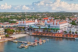 Oranjestad, Aruba
 -
 Bonaire
 -
 Curacao
 -
 Mount Scenery, Saba
 -
 Sint Eustatius
 -
 Sint Maarten

.jpg)


.jpg)

Grouping of islands
The islands have also been informally grouped in the following ways.
- Geographically, by location in the Lesser Antilles (in alphabetical order):
- ABC islands, for Aruba, Bonaire, and Curaçao (within the Leeward Antilles group)
- SSS islands, for Saba, Sint Eustatius, and Sint Maarten (within the Leeward Islands group)
- Politically, by constitutional status (in order of population size):
- CAS islands, for Curaçao, Aruba, and Sint Maarten (constituent countries of the Kingdom of the Netherlands)
- BES islands, for Bonaire, Sint Eustatius, and Saba (special municipalities of the Netherlands)
See also
- Central banks and currencies of the Caribbean
- Dutch navy in the Caribbean
- Curaçaoans in the Netherlands
- Arubans in the Netherlands
- Dutch nationality law
Notes
References
- ^ "Landsverordening officiële talen". wetten.nl. 28 March 2007. Retrieved 5 January 2011.
- ^ Papiamentu/Ingles Dikshonario, Ratzlaff, Betty; pg. 11
- ^ a b "Status change means Dutch Antilles no longer exists". BBC News. BBC. 10 October 2010. Retrieved 11 October 2010.
- ^ "Antillen opgeheven op 10-10-2010" (in Dutch). NOS. 1 October 2009. Retrieved 1 October 2009.
- ^ Oostindie and Klinkers 2001: 12–13
- ^ Oostindie and Klinkers 2001: 29–32
- ^ Oostindie and Klinkers 2001: 41–44
- ^ Overheid.nl – KONINKLIJK BESLUIT van 3 maart 1951, houdende de eilandenregeling Nederlandse Antillen
- ^ Oostindie and Klinkers 2001: 47–56
- ^ a b c d e f Zaken, Ministerie van Algemene (19 May 2015). "Waaruit bestaat het Koninkrijk der Nederlanden?" (in Dutch). Rijksoverheid.nl.
- ^ a b COUNTRY COMPARISON GDP , Central Intelligence Agency.
- ^ "Rijksdienst Carbische Nederland (Rijksdienst Dutch Caribbean)". Government of the Netherlands. Archived from the original on 2 July 2015. Retrieved 4 June 2015.
- ^ "Visa for the Dutch Caribbean". Netherlands Embassy in the United Kingdom. Archived from the original on 19 January 2014. Retrieved 4 June 2015.
External links
| ||
.svg)
Even though the referenda held in the early 1990s resulted in a position in favour of retaining the Netherlands Antilles, the arrangement continued to be an unhappy one. Between June 2000 and April 2005, each island of the Netherlands Antilles had a new referendum on its future status. The four options that could be voted on were the following:
- closer ties with the Netherlands
- remaining within the Netherlands Antilles
- autonomy as a country within the Kingdom of the Netherlands (status aparte)
- independence
Of the five islands, Sint Maarten and Curaçao voted for status aparte, Saba and Bonaire voted for closer ties to the Netherlands, and Sint Eustatius voted to stay within the Netherlands Antilles.
On 26 November 2005, a Round Table Conference (RTC) was held between the governments of the Netherlands, Aruba, the Netherlands Antilles, and each island in the Netherlands Antilles. The final statement to emerge from the RTC stated that autonomy for Curaçao and Sint Maarten, plus a new status for Bonaire, Sint Eustatius, and Saba (BES) would come into effect by 1 July 2007.[1] On 12 October 2006, the Netherlands reached an agreement with Bonaire, Sint Eustatius, and Saba; this agreement would make these islands special municipalities.[2]
On 3 November 2006, Curaçao and Sint Maarten were granted autonomy in an agreement,[3] but this agreement was rejected by the then island council of Curaçao on 28 November.[4] The Curaçao government was not sufficiently convinced that the agreement would provide enough autonomy for Curaçao.[5] On 9 July 2007 the new island council of Curaçao approved the agreement previously rejected in November 2006.[6] A subsequent referendum approved the agreement as well.
The acts of parliament integrating the "BES" islands (Bonaire, Sint Eustatius and Saba) into the Netherlands were given royal assent on 17 May 2010. After ratification by the Netherlands (6 July), the Netherlands Antilles (20 August), and Aruba (4 September), the Kingdom act amending the Charter for the Kingdom of the Netherlands with regard to the dissolution of the Netherlands Antilles was signed off by the three countries in the closing Round Table Conference on 9 September 2010 in The Hague.
Constitution
The Constitution of the Netherlands Antilles was proclaimed on 29 March 1955 by Order-in-Council for the Kingdom. Together with the Island Regulation of the Netherlands Antilles it formed the constitutional basis for the Netherlands Antilles. The fact that the Constitution depended on the Island Regulation, and the fact that the Island Regulation gave fairly large autonomy to the different island territories, and the fact that the Island Regulation was older than the Constitution, has led many scholars to describe the Netherlands Antilles as a federal arrangement.[7]
The head of state was the ruling monarch of the Netherlands, who was represented in the Netherlands Antilles by a governor. The governor and the council of ministers, chaired by a prime minister, formed the government. The Netherlands Antilles had a unicameral legislature called the Estates of the Netherlands Antilles. Its 22 members were fixed in number for the islands making up the Netherlands Antilles: fourteen for Curaçao, three each for Sint Maarten and Bonaire, and one each for Saba and Sint Eustatius.
The Netherlands Antilles were not part of the European Union, but instead listed as overseas countries and territories (OCTs). This status was kept for all the islands after dissolution, and will be kept until at least 2015.
Island territories
The Island Regulation originally divided the Netherlands Antilles into four island territories: Aruba, Bonaire, Curaçao (ABC), and the Windward islands. In 1983, the island territory of the Windward islands was split up to form the new island territories of Sint Maarten, Saba, and Sint Eustatius (SSS). In 1986, Aruba seceded from the Netherlands Antilles, reducing the number of island territories to five. After the dissolution of the Netherlands Antilles in 2010, Curaçao and Sint Maarten became autonomous countries within the Kingdom and Bonaire, Sint Eustatius and Saba (BES) became special municipalities of the Netherlands.
| Flag | Name | Capital | Area (km²) | Remarks |
|---|---|---|---|---|
| Curaçao | Willemstad | 444 | Capital of the Netherlands Antilles[8] | |
| Bonaire | Kralendijk | 288 | ||
| Sint Maarten | Philipsburg | 34 | Were parts of the island territory of the Windward islands until 1 January 1983 | |
| Sint Eustatius | Oranjestad | 21 | ||
| Saba | The Bottom | 13 | ||
| Aruba | Oranjestad | 193 | Seceded on 1 January 1986 | |
| Netherlands Antilles | Willemstad | 993 |
Geography


The two island groups of which the Netherlands Antilles consisted were:
- the "Leeward Islands" (Benedenwindse Eilanden or ABC islands), part of the Leeward Antilles island chain off the Venezuelan coast.
- Aruba
- Bonaire, including an islet called Klein Bonaire ("Little Bonaire")
- Curaçao, including an islet called Klein Curaçao ("Little Curaçao")
- the "Windward Islands" (Bovenwindse Eilanden or SSS islands) east of Puerto Rico and the Virgin Islands. These are part of what are in English called the Leeward Islands, but French, Spanish, Dutch and the English spoken locally these are considered part of the Windward Islands.
- Sint Maarten, the southern half of the island Saint Martin (the northern half, Saint-Martin, is an overseas collectivity of France).
- Saba
- Sint Eustatius
The windward islands are all of volcanic origin and hilly, leaving little ground suitable for agriculture. The leeward islands have a mixed volcanic and coral origin. The highest point was Mount Scenery, 887 metres (2,910 ft), on Saba (also the highest point in all the Kingdom of the Netherlands).
Climate
The Netherlands Antilles had a tropical climate, with warm weather all year round. The windward islands are subject to hurricanes in the summer months, while the leeward Islands are warmer and drier.
Economy
Tourism, petroleum transshipment and oil refinement (on Curaçao), as well as offshore finance were the mainstays of this small economy, which was closely tied to the outside world. The islands enjoyed a high per capita income and a well-developed infrastructure as compared with other countries in the region.
Almost all consumer and capital goods were imported, with Venezuela, the United States, and Mexico being the major suppliers, as well as the Dutch government which supports the islands with substantial development aid. Poor soils and inadequate water supplies hampered the development of agriculture. The Antillean guilder had a fixed exchange rate with the United States dollar of 1.79:1.
Demographics
A large percentage of the Netherlands Antilleans descended from European colonists and African slaves who were brought and traded here from the 17th to 19th centuries. The rest of the population originated from other Caribbean islands as well as Latin America, East Asia and elsewhere in the world. In Curaçao there was a strong Jewish element going back to the 17th century.
The language Papiamentu was predominant on Curaçao and Bonaire (as well as the neighboring island of Aruba). This creole descended from Portuguese and West African languages with a strong admixture of Dutch, plus subsequent lexical contributions from Spanish and English. An English-based creole dialect, formally known as Netherlands Antilles Creole, was the native dialect of the inhabitants of Sint Eustatius, Saba and Sint Maarten.
After a decades-long debate, English and Papiamentu were made official languages alongside Dutch in early March 2007.[9] Legislation was produced in Dutch but parliamentary debate was in Papiamentu or English, depending on the island. Due to a massive influx of immigrants from Spanish speaking territories such as the Dominican Republic in the Windward Islands, and increased tourism from Venezuela in the Leeward Islands, Spanish had also become increasingly used.
The majority of the population were followers of the Christian faith, with a Protestant majority in Sint Eustatius and Sint Maarten, and a Roman Catholic majority in Bonaire, Curaçao and Saba. Curaçao also hosted a sizeable group of followers of the Jewish faith, descendants of a Portuguese group of Sephardic Jews that arrived from Amsterdam and Brazil from 1654.
Most Netherlands Antilleans were Dutch citizens and this status permitted and encouraged the young and university-educated to emigrate to the Netherlands. This exodus was considered to be to the islands' detriment, as it created a brain drain. On the other hand, immigrants from the Dominican Republic, Haiti, the Anglophone Caribbean and Colombia had increased their presence on these islands in later years.
Culture

The origins of the population and location of the islands gave the Netherlands Antilles a mixed culture.
Tourism and overwhelming media presence from the United States increased the regional United States influence. On all the islands, the holiday of Carnival had become an important event after its importation from other Caribbean and Latin American countries in the 1960s. Festivities included "jump-up" parades with beautifully colored costumes, floats, and live bands as well as beauty contests and other competitions. Carnival on the islands also included a middle-of-the-night j'ouvert (juvé) parade that ended at sunrise with the burning of a straw King Momo, cleansing the island of sins and bad luck.
Sports
Netherlands Lesser Antilles competed in the Winter Olympics of 1988, notably finishing 29th in the bobsled, ahead of Jamaica who famously competed but finished 30th.
Baseball is by far the most popular sport. Several players have made it to the Major Leagues, such as Jair Bogaerts, Xander Jan Bogaerts, Hensley Meulens, Randall Simon, Andruw Jones, Jair Jurrjens, Roger Bernadina, Sidney Ponson, Didi Gregorius, Shairon Martis, Wladimir Balentien, and Yurendell DeCaster. Xander Bogaerts competed in the 2013 World Series for the Boston Red Sox against the St. Louis Cardinals. Andruw Jones played for the Atlanta Braves in the 1996 World Series hitting two home runs in the first game against the New York Yankees.
Three athletes from the former Netherlands Antilles competed in the 2012 Summer Olympics. They, alongside one athlete from South Sudan, competed under the banner of Independent Olympic Athletes.
Miscellaneous topics
Unlike the metropolitan Netherlands, same-sex marriages were not performed in the Netherlands Antilles, but those performed in other jurisdictions were recognised.
The main prison of the Netherlands Antilles was Koraal Specht, later known as Bon Futuro. It was known for ill treatment of prisoners and bad conditions throughout the years.[10]
The late Venezuelan President Hugo Chávez claimed that the Netherlands was helping the United States to invade Venezuela due to military games in 2006.[11] Curaçao is under consideration as a Cooperative Security Location, not a full Main Operating Base.
See also
- American West Indies
- British West Indies
- Danish West Indies
- French West Indies
- Spanish West Indies
- Dutch West Indies 1630–1975
Notes
- ^ "Closing statement of the first Round Table Conference". Ministry of the Interior and Kingdom Relations. 26 November 2005. Retrieved 19 July 2011.
- ^ Radio Netherlands (12 October 2006). "Caribbean islands become Dutch municipalities". Retrieved 2 February 2007.
- ^ "Curaçao and St Maarten to have country status". Government.nl. 3 November 2006. Retrieved 21 January 2008.
- ^ "Curacao rejects final agreement". Ministry of the Interior and Kingdom Relations. 29 November 2006. Retrieved 2 February 2007. [dead link]
- ^ "Curaçao verwerpt slotakkoord". Nu.nl. Retrieved 10 October 2010.
- ^ The Daily Herald St. Maarten (9 July 2007). "Curaçao IC ratifies November 2 accord". Archived from the original on 11 July 2007. Retrieved 13 July 2007.
- ^ Borman 2005:56
- ^ "Netherlands Antilles no more". Stabroek News. Retrieved 10 October 2010.
- ^ "Antilles allow Papiamentu as official language", The Times Hague/Amsterdam/Rotterdam, 9 March 2007, page 2.
- ^ Rob Gollin (23 February 1998). "Koraalspecht is het ergst, zeggen zelfs Colombiaanse gevangenen" (in Dutch). de Volkskrant. Retrieved 6 October 2013.
- ^ "Chavez Says Holland Plans to Help US Invade Venezuela". Spiegel.de. 11 April 2006. Retrieved 10 October 2010.
References
- Borman, C. (2005) Het Statuut voor het Koninkrijk, Deventer: Kluwer.
- Oostindie, G. and Klinkers, I. (2001) Het Koninkrijk inde Caraïben: een korte geschiedenis van het Nederlandse dekolonisatiebeleid 1940–2000. Amsterdam: Amsterdam University Press.
External links
 Definitions from Wiktionary
 Media from Commons
 News from Wikinews
 Quotations from Wikiquote
 Texts from Wikisource
 Textbooks from Wikibooks
 Resources from Wikiversity
 Travel information from Wikivoyage
- Government
- GOV.an – Main governmental site
- Antillenhuis – Cabinet of the Netherlands Antilles' Plenipotentiary Minister in the Netherlands
- Central Bank of the Netherlands Antilles
- General information
- "Netherlands Antilles". The World Factbook (2024 ed.). Central Intelligence Agency.
- Netherlands Antilles from UCB Libraries GovPubs
- Netherlands Antilles at Curlie
 Wikimedia Atlas of Netherlands Antilles
- History
- Template:En icon Template:Es icon Method of Securing the Ports and Populations of All the Coasts of the Indies from 1694. The last five pages of the book are about life, economy and culture of the Netherlands Antilles.
| |||||||||||||||||||||||||||||||||||||||||||||||||||||||||||||||||||||||||||||||||||||||||||


- Use dmy dates from March 2013
- Dutch Caribbean
- Geography of the Caribbean
- Regions of the Netherlands
- Subdivisions of the Netherlands
- Dependent territories in the Caribbean
- Netherlands Antilles
- Former countries in the Caribbean
- Dependent territories in North America
- Dutch colonization of the Americas
- Dutch-speaking countries and territories
- Former Dutch colonies
- Island countries
- Kingdom of the Netherlands
- Lesser Antilles
- Special territories of the European Union
- States and territories established in 1954
- States and territories disestablished in 2010
- Netherlands Antilles articles correct after Dissolution
- English-speaking countries and territories