
Virginia in the American Civil War: Difference between revisions
→West Virginia split: 1866 was SCOTUS case - vote was in 1863 |
|||
| Line 18: | Line 18: | ||
[[Berkeley County, West Virginia|Berkeley County]] and [[Jefferson County, West Virginia|Jefferson County]] (in the extreme northern edge of the state) remained in the Confederacy and Virginia throughout the Civil War, and were not part of the formation of the [[State of Kanawha]], renamed [[West Virginia]], when it was admitted to the Union with 48 former Virginia counties on [[January 1]], [[1863]]. Rather, after the War, during [[Reconstruction]], in [[1866]], these two counties decided in local referendums that they also wanted to be part of the new state of West Virginia, bringing the total to 50. |
[[Berkeley County, West Virginia|Berkeley County]] and [[Jefferson County, West Virginia|Jefferson County]] (in the extreme northern edge of the state) remained in the Confederacy and Virginia throughout the Civil War, and were not part of the formation of the [[State of Kanawha]], renamed [[West Virginia]], when it was admitted to the Union with 48 former Virginia counties on [[January 1]], [[1863]]. Rather, after the War, during [[Reconstruction]], in [[1866]], these two counties decided in local referendums that they also wanted to be part of the new state of West Virginia, bringing the total to 50. |
||
With the formation of West Virginia, Virginia no longer shared a border with Pennsylvania. |
With the formation of West Virginia, Virginia no longer shared a border with Pennsylvania. Even in the 20th century, there were still some disputes about the precise location of the border in some of the northern mountain reaches of Virginia between [[Loudoun County, Virginia|Loudoun County]] and [[Jefferson County, West Virginia]]. In 1991, both state legislatures appropriated money for a boundary commission to look into 15 miles of the border area. [http://www.virginiaplaces.org/regions/westva.html] |
||
''See also article [[West Virginia in the Civil War]]'' |
''See also article [[West Virginia in the Civil War]]'' |
||
Revision as of 01:09, 7 November 2007
 |
|
Confederate States in the American Civil War |
|---|
|
|
| Dual governments |
| Territory |
|
Allied tribes in Indian Territory |
Virginia began a convention about secession on February 13, 1861 after six states seceded to form the Confederate States of America on February 4. The convention deliberated for several months, but, on April 15 Lincoln called for troops from all states still in the Union in response to the firing on Fort Sumter. On April 17, 1861 the convention voted to secede. With the entry of Virginia into the Confederacy, the decision to move the Confederate capital from Montgomery, Alabama to Richmond was made on May 6 and enacted on May 29. Virginians ratified the articles of secession on May 23.[1] The following day, the Union army moved into northern Virginia and captured Alexandria without a fight.
The first major battle of the Civil War occurred on July 21, 1861. Union forces attempted to take control of the railroad junction at Manassas for use as a supply line, but the Confederate Army had moved its forces by train to meet the Union. The Confederates won the First Battle of Manassas (known as "Bull Run"in Northern naming convention) and the year went on without a major fight.
The first and last significant battles were held in Virginia. The first being the Battle of Manassas and the last being Battle of Appomattox Courthouse. During the American Civil War, Richmond was the capital of the Confederate States of America. The White House of the Confederacy, located a few blocks north of the State Capital, was home to the family of Confederate President Jefferson Davis.
In April of 1865, Richmond was burned by a retreating Confederate Army and was returned to Northern control. Virginia was administered as the "First Military District" during the Reconstruction period (1865-1870) under General John Schofield. The state formally rejoined the Union on January 26, 1870.
Industrialization
Various textile production was present prior to 1861 but nothing of great significance. A center of iron production during the civil war was located in Richmond at Tredegar Iron Works. Tredegar was run partially by slave labor, and it produced most of the artillery for the war, making Richmond an important point to defend.
West Virginia split
Virginia was one of the last states to join the Confederacy largely because the lack of support in the North-Western region due to the lack of slavery in this region. After it did join an upheaval in the region soon followed. After a successful revolt, the area consisting of 48 counties became known as the State of Kanawha and later West Virginia. The act was upheld by the United States Supreme Court in 1870.
Berkeley County and Jefferson County (in the extreme northern edge of the state) remained in the Confederacy and Virginia throughout the Civil War, and were not part of the formation of the State of Kanawha, renamed West Virginia, when it was admitted to the Union with 48 former Virginia counties on January 1, 1863. Rather, after the War, during Reconstruction, in 1866, these two counties decided in local referendums that they also wanted to be part of the new state of West Virginia, bringing the total to 50.
With the formation of West Virginia, Virginia no longer shared a border with Pennsylvania. Even in the 20th century, there were still some disputes about the precise location of the border in some of the northern mountain reaches of Virginia between Loudoun County and Jefferson County, West Virginia. In 1991, both state legislatures appropriated money for a boundary commission to look into 15 miles of the border area. [2]
See also article West Virginia in the Civil War
Notable (Confederate) leaders from Virginia
-

Gen.
Robert E. Lee -

Lt. Gen.
Thomas J. Jackson -

Maj. Gen.
J. E. B. Stuart -
-
Lt. Gen.
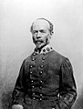
A. P. Hill -

Lt. Gen.
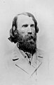
Richard S. Ewell -
Maj. Gen.
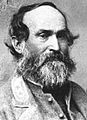
Jubal A. Early -
Maj. Gen.
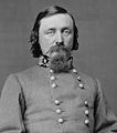
George Pickett -
Maj. Gen.
Edward Johnson -

Maj. Gen.
Fitzhugh Lee -
Brig. Gen.
Lewis A. Armistead -
Gov.
John Letcher


See also
- Richmond in the Civil War
- Winchester in the Civil War
- Virginia Units in the Civil War
- Stonewall Jackson's Headquarters Museum
- Army of Northern Virginia
External links
- National Park Service map of Civil War sites in Virginia: 1861-62
- National Park Service map of Civil War sites in Virginia: 1863
- National Park Service map of Civil War sites in Virginia: 1864
- National Park Service map of Civil War sites in Virginia: 1865